U.S. Route 40 in Colorado
| ||||
|---|---|---|---|---|
|
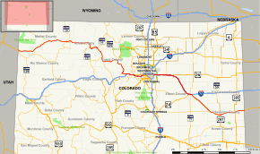
Map of Colorado with US 40 highlighted in red | ||||
| Route information | ||||
| Maintained by CDOT | ||||
| Length: | 496.442 mi[1] (798.946 km) | |||
| Existed: | 1926 – present | |||
| Major junctions | ||||
| West end: |
| |||
| East end: |
| |||
| Highway system | ||||
|
Colorado State Highways
| ||||
_(LOC).jpg)
In the U.S. state of Colorado, U.S. Route 40 is a major east–west route. It crosses the Rocky Mountains, passing over the Continental Divide at Berthoud Pass before descending to the front range. It then traverses through the Denver Metro Area, then exits by following I-70 and US 287. It is concurrent with US 287 for about 145 miles to Kit Carson. US 40 exits into Kansas east of Arapahoe in Cheyenne.
Route description
Entering Colorado to the south of Dinosaur National Monument, U.S. 40 runs east through the small town of Dinosaur along Brontosaurus Boulevard. The route continues a generally easterly course though Moffat and Routt counties, passing through several small communities along the way. It generally follows the course of the Yampa River. U.S. 40 becomes Lincoln Avenue as it runs through historic downtown Steamboat Springs, Colorado.
Taking a circuitous route through Rabbit Ears Pass, Muddy Pass and Berthoud Pass it descends the escarpment along the eastern edge of the Rocky Mountains. Just to the east of Empire, it merges with Interstate 70 for the first time. US 40 and I-70 will frequently share pavement across the U.S. The route leaves I-70 at exit 244, to the west of Idaho Springs and rejoins it again at between exits 252 and 254 in El Rancho. It parallels I-70, mostly as a frontage road, until the intersection with State Highway 26 to the south of Golden[2][3]
Beginning in Golden, US 40 becomes Colfax Avenue, the main east–west thoroughfare through the Denver-Aurora Metropolitan Area. Along with US 40, the entire route along Colfax Avenue is cosigned as Business Loop 70. The route travels northeast through Golden, then turns due east to travel through Lakewood, Denver, and Aurora. Among the sights to be seen along US 40 is Lake Steam Bath, once the location of a thriving health industry centered on tuberculosis sanatoriums. Also along Colfax Avenue in Denver is the Denver branch of the United States Mint, which produces 50 million coins per day. US 40 rejoins I-70 at exit 288, just to the east of Aurora.[3][4][5]
At exit 359 in Limon, US 40 leaves I-70 along Main Street, which it shares with Business Loop 70, US 24, US 287, and SH 71. US 40/US 287 continues to the southeast to the town of Kit Carson. From there, it leaves US 287 and continues east through the towns of Cheyenne Wells and Arapahoe before entering the state of Kansas.[3][4]
Major intersections
| County | Location | mi[6] | km | Destinations | Notes | |||
|---|---|---|---|---|---|---|---|---|
| Moffat | | 0.000 | 0.000 | |||||
| Dinosaur | 2.913 | 4.688 | ||||||
| Blue Mountain | 11.018 | 17.732 | former SH 387 | |||||
| Maybell | 59.781 | 96.208 | ||||||
| Craig | 89.322 | 143.750 | West end of SH 13 overlap; former SH 355 north | |||||
| 90.531 | 145.696 | former SH 13 south | ||||||
| 90.838 | 146.190 | East end of SH 13 overlap | ||||||
| Routt | Steamboat Springs | 130.773 | 210.459 | former SH 129 | ||||
| 134.414 | 216.318 | Mt. Werner Road | Interchange | |||||
| | 136.515 | 219.700 | ||||||
| Grand |
No major junctions | |||||||
| 154.070 | 247.952 | Rabbit Ears Pass summit (Continental Divide) | ||||||
| Jackson | | 157.327 | 253.193 | |||||
| 157.512 | 253.491 | Muddy Pass summit (Continental Divide) | ||||||
| Grand | | 178.257 | 286.877 | |||||
| Kremmling | 184.529 | 296.971 | ||||||
| | 209.165 | 336.618 | ||||||
| Granby | 211.081 | 339.702 | ||||||
| 242.972 | 391.026 | Berthoud Pass summit (Continental Divide) | ||||||
| Clear Creek | | 257.684 232.333 | 414.702 373.904 | West end of I-70/US 6 overlap | ||||
| | 232.333– 244.260 | 373.904– 393.098 | See I-70 | |||||
| | 244.260 257.146 | 393.098 413.836 | East end of I-70 overlap; no access from US 40 west to I-70 east | |||||
| | 257.751 269.441 | 414.810 433.623 | East end of US 6 overlap | |||||
| | 271.489 | 436.919 | ||||||
| Jefferson | | 272.552 | 438.630 | |||||
| | 276.180 | 444.469 | ||||||
| | 276.920 0.374 | 445.660 0.602 | ||||||
| | 0.194 251.318 | 0.312 404.457 | West end of I-70 overlap; westbound exit and eastbound entrance | |||||
| | 252.244 | 405.947 | Chief Hosa | I-70 exit 253 | ||||
| | 253.528 279.244 | 408.014 449.400 | East end of I-70 overlap | |||||
| | 280.570 | 451.534 | Lookout Mountain Road - Buffalo Bill's Grave & Museum, Lookout Mountain Nature Center, Boettcher Mansion | former SH 68 | ||||
| | 281.977 | 453.798 | ||||||
| Golden | 284.888 | 458.483 | West end of I-70 Bus. overlap; former SH 26 (older SH 93 south) | |||||
| 285.716 | 459.815 | Heritage Road | former SH 93 north | |||||
| 286.871 | 461.674 | |||||||
| | 287.903 | 463.335 | ||||||
| Lakewood | 291.444 | 469.034 | ||||||
| 292.943 | 471.446 | |||||||
| 294.273 | 473.586 | |||||||
| City and County of Denver | 296.157 | 476.618 | West end of US 287 overlap; interchange | |||||
| 296.792 | 477.640 | |||||||
| 300.625 | 483.809 | |||||||
| Adams–Arapahoe county line | Aurora | 306.341 | 493.008 | |||||
| 312.142 288.219 | 502.344 463.844 | West end of I-70 / US 36 overlap; east end of I-70 Bus. overlap; no access from US 40 east to I-70 west | ||||||
| See I-70 for exits | ||||||||
| Lincoln | Limon | 359.499 0.498 | 578.558 0.801 | West end of I-70 Bus. overlap; east end of I-70 overlap | ||||
| 0.000 376.714 | 0.000 606.262 | West end of US 24 overlap | ||||||
| 377.668 | 607.798 | West end of SH 71 overlap | ||||||
| 378.795 | 609.611 | East end of SH 71 overlap | ||||||
| 379.193 | 610.252 | |||||||
| | 380.464 386.010 | 612.297 621.223 | East end of I-70 Bus./US 24 overlap | |||||
| | 397.833 | 640.250 | former SH 109 north | |||||
| Hugo | 399.092 | 642.276 | Third Avenue | former SH 109 south | ||||
| Cheyenne | Aroya | 425.472 | 684.731 | |||||
| Kit Carson | 445.142 | 716.387 | ||||||
| | 446.051 | 717.850 | East end of US 287 overlap | |||||
| Cheyenne Wells | 470.311 | 756.892 | West end of US 385 overlap | |||||
| | 470.885 | 757.816 | East end of US 385 overlap | |||||
| | 486.924 | 783.628 | ||||||
1.000 mi = 1.609 km; 1.000 km = 0.621 mi
| ||||||||
See also
Related U.S. Routes
References
- ↑ Colorado Department of Transportation, Highway Data, accessed July 2007
- ↑ Brusca, Frank X. (2002). "US 40 Scrapbook: Colorado". U.S. Route 40: America's Golden Highway. route40.net. Archived from the original on 2007-09-27. Retrieved 2007-05-21.
- 1 2 3 Salek, Matthew E. (2006). "US 40". Colorado Highways. Retrieved 2007-05-22.
- 1 2 Mapsource. Garmin Ltd. 2003.
- ↑ Royston, Reggie (2001). "Denver's Road of Riches: Colfax Avenue". National Geographic News. National Geographic Society. Retrieved 2007-05-22.
- ↑ Colorado Department of Transportation, Highway Data Explorer, accessed November 2013
External links
| Previous state: Utah |
Colorado | Next state: Kansas |