Columbia Glacier (Washington)
| Columbia Glacier | |
|---|---|
|
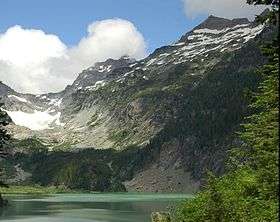
Columbia Glacier in left background, looking North, in 2005.[1] | |
 Columbia Glacier | |
| Type | Mountain glacier |
| Coordinates | 47°57′45″N 121°20′55″W / 47.96250°N 121.34861°WCoordinates: 47°57′45″N 121°20′55″W / 47.96250°N 121.34861°W[2] |
| Area | .33 sq mi (0.85 km2) |
| Length | 1 mi (1.6 km) |
| Thickness | 246 ft (75 m) |
| Terminus | Moraine |
| Status | Retreating |
- See also Columbia Glacier (Alaska).
Columbia Glacier is a glacier located in the Henry M. Jackson Wilderness in the U.S. state of Washington. It descends from 5,600 ft (1,700 m) to 4,700 ft (1,400 m) above sea level. It is surrounded by Columbia Peak, Monte Cristo Peak, and Kyes Peak and is a source of water for Blanca Lake and Troublesome Creek, a tributary of the North Fork Skykomish River.
The glacier retreated 278 ft (85 m) between 1979 and 2004. The retreat is due to recent reduced winter snowpack and more summer melting leading to negative mass balance. The glacier is in disequilibrium with climate and will continue to thin and retreat.[3]
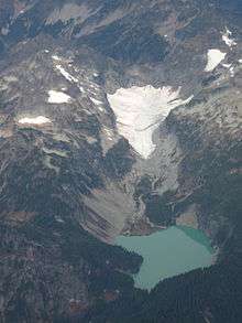
Aerial view of Columbia Glacier in early autumn, 2009
See also
References
- ↑ Blanca Lake, WA (Map). TopoQwest (United States Geological Survey Maps). Retrieved 2012-10-20.
- ↑ "Columbia Glacier". Geographic Names Information System. United States Geological Survey. Retrieved 2012-10-20.
- ↑ Pelto, Mauri. "The Impact of sampling density on glacier mass balance determination". Department of Environmental Science, Nichols College. Retrieved 2012-10-20.
| Wikimedia Commons has media related to: |
This article is issued from Wikipedia - version of the 8/20/2016. The text is available under the Creative Commons Attribution/Share Alike but additional terms may apply for the media files.