Connecticut Route 209
| ||||
|---|---|---|---|---|
|
Map of Litchfield County in northwestern Connecticut with Route 209 highlighted in red | ||||
| Route information | ||||
| Maintained by ConnDOT | ||||
| Length: | 2.93 mi[1] (4.72 km) | |||
| Existed: | 1963 – present | |||
| Major junctions | ||||
| South end: |
| |||
| North end: |
| |||
| Location | ||||
| Counties: | Litchfield | |||
| Highway system | ||||
| ||||

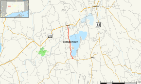
Route 209 is a rural state highway in northwestern Connecticut, running from the Lakeside part of Morris to the borough of Bantam in the town of Litchfield.
Route description
Route 209 begins at an intersection with Route 109 east of the Lakeside section of Morris. It heads north along the west shore of Bantam Lake for 1.9 miles (3.1 km) into the town of Litchfield. After crossing the Bantam River 0.9 miles (1.4 km) later, it soon ends at an intersection with US 202 within the borough of Bantam. Route 209 is known as Bantam Lake Road for its entire length.[1]
History
The road connecting the town of Morris with the borough of Bantam going alongside Bantam Lake was designated as a secondary state highway known as Highway 310 in 1922. In the 1932 state highway renumbering, old Highway 310 was renumbered to Route 109. In 1963, Route 109 was reconfigured such that it went west toward Washington instead. The former section of Route 109 along the west shore of Bantam Lake was renumbered to Route 209. The route has had no changes since.[2]
Junction list
The entire route is in Litchfield County.
| Location | mi[1] | km | Destinations | Notes | |
|---|---|---|---|---|---|
| Morris | 0.00 | 0.00 | |||
| Litchfield | 2.93 | 4.72 | Northern terminus of CT 209 | ||
| 1.000 mi = 1.609 km; 1.000 km = 0.621 mi | |||||
References
- 1 2 3 Connecticut State Highway Log Archived 2015-07-26 at WebCite
- ↑ Connecticut Routes, Route 209