Route 220 (Connecticut–Massachusetts)
| |||||||
|---|---|---|---|---|---|---|---|
|
Map of northern Connecticut with CT 220 highlighted in solid red and of southern Massachusetts with MA 220 highlighted in dotted red | |||||||
| Route information | |||||||
| Length: |
7.95 mi (12.79 km) Connecticut: 5.78 mi[1] Massachusetts: 2.17 mi[2] | ||||||
| Existed: | 1936 – present | ||||||
| Major junctions | |||||||
| West end: |
| ||||||
|
| |||||||
| North end: |
| ||||||
| Location | |||||||
| Counties: | CT: Tolland, MA: Hampden | ||||||
| Highway system | |||||||
| |||||||


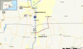
Route 220 is a state route in northern Connecticut and western Massachusetts, serving the southeastern suburbs of Springfield. The route runs in an "L" pattern and connects the town of Enfield, Connecticut to the town of East Longmeadow. The route serves the Thompsonville and North Thompsonville sections of Enfield, connecting them to East Longmeadow center. In Connecticut, Route 220 is signed east-west. In Massachusetts, Route 220 is a town-maintained road and it is signed north-south.
Route description
Route 220 begins as Elm Street at an intersection with US 5 in the Thompsonville section of the town of Enfield. It heads east, intersecting I-91 (at Exit 48) after 0.4 miles (0.64 km) near Enfield Square Mall. Route 220 then shifts to use Shaker Road heading northeast for about three miles (5 km) and intersecting with Route 192 along the way. In the vicinity of the state correctional facility, Route 220 turns north along Taylor Road. Shaker Road continues as unsigned Special Service Road 404, which leads to the main building of the correctional facility. Route 220 runs for another 1.4 miles (2.3 km) to the Massachusetts state line at East Longmeadow.[1] In East Longmeadow, Route 220 continues for another 2.2 miles (3.5 km) as Shaker Road, ending at a complex seven-way intersection (the East Longmeadow Rotary) that involves Route 83 and Route 186, among other roads.
History
In 1936, modern Route 220 was designated as a route from Route 192 via the State Correctional Facility to the Massachusetts state line, with Massachusetts continuing the route as a town-maintained numbered road to East Longmeadow center. As part of the 1962 Route Reclassification Act, the Taylor Road portion of Route 220 was to be redesignated as part of an extended Route 191. However, in 1963, the decision was reversed and Route 220 remained intact with an additional westward extension along Elm Street to US 5.[3]
Junction list
| State | County | Location | mi | km | Destinations | Notes |
|---|---|---|---|---|---|---|
| Connecticut | Hartford | Enfield | 0.00 | 0.00 | ||
| 0.44 | 0.71 | Exit 48 (I-91) | ||||
| 2.86 | 4.60 | |||||
| 4.38 | 7.05 | Shaker Road (Special Service Road 404) | ||||
| 5.78 0.00 | 9.30 0.00 | Connecticut–Massachusetts state line | ||||
| Massachusetts | Hampden | East Longmeadow | 2.17 | 3.49 | Northern terminus of Route 220 at East Longmeadow 5 corners. | |
| 1.000 mi = 1.609 km; 1.000 km = 0.621 mi | ||||||