Route 83 (Connecticut–Massachusetts)
| |||||||
|---|---|---|---|---|---|---|---|
|
Map of northern Connecticut with CT 83 highlighted in solid red and of southern Massachusetts with MA 83 highlighted in dotted red | |||||||
| Route information | |||||||
| Length: |
35.65 mi (57.37 km) Connecticut: 27.56 mi[1] Massachusetts: 8.09 mi[2] | ||||||
| Existed: | 1932 – present | ||||||
| Major junctions | |||||||
| South end: |
New London Turnpike (near | ||||||
|
| |||||||
| North end: |
| ||||||
| Location | |||||||
| Counties: |
CT: Hartford, Tolland, MA: Hampden | ||||||
| Highway system | |||||||
| |||||||


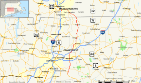
Route 83 is a north–south state highway in the Greater Hartford and Greater Springfield areas of the U.S. states of Connecticut and Massachusetts. It serves as the main north–south artery for the towns of Manchester, Vernon, and Ellington and continues through East Longmeadow center into downtown Springfield. The route in Massachusetts is town-maintained, except for the ramps connecting to US 5 parallel to I-91.
Route description

Route 83 begins at the southern end of New London Turnpike in Glastonbury near its junction with Route 2 at Exit 10. After crossing Route 2, it then heads north and crosses Route 94 before entering Manchester, where it serves as the main north-south thoroughfare of the town. Just before the center of town, it intersects I-384 at Exit 3. Within the town center of Manchester, a 0.77-mile (1.24 km) segment is town maintained between Hartford Road and Center St, the latter of which carries US 6/44, the town's main east-west thoroughfare. It then continues north, and comes to a junction with Route 30 at I-84 Exit 63. Route 83 overlaps with Route 30 for 1.50 miles (2.41 km) from Manchester into Vernon, intersecting I-84 once again at Exit 64 before Route 30 turns off to the east. It then continues north in Vernon as a 4-lane road where it narrows to 2 lanes shortly before a 0.81 mile overlap with Route 74. It then turns north once again on the western edge of Rockville Center, and crosses into Ellington, where it has juctions with the northern end of Route 286, and with Route 140 in the center of town. It then continues north into Somers, where it has a brief (0.02 mile) overlap with Route 190. Route 83 continues northwest, and crosses the Massachusetts state line into East Longmeadow.[1] In East Longmeadow, it proceeds north as Somers Road until a complex seven-way intersection (the East Longmeadow Rotary) that involves Route 186 and Route 220 among other roads. Beyond the Rotary, Route 83 continues northwest through East Longmeadow along North Main Street. After entering the city of Springfield, Route 83 shifts onto Belmont Avenue until it reaches a six-way intersection (known as "the X") where the route shifts again to Sumner Avenue. Route 83 follows Sumner Avenue to its end then turns south on Longhill Street, which provides access to the ramps leading to I-91 and US 5.
History
In the 1920s, the segment from Glastonbury to Manchester was called State Highway 164, while the segment from Manchester to Somers was called State Highway 108. The current Route 83 was established from these two state highways in the 1932 renumbering. At about the same time, Massachusetts extended the route through East Longmeadow and Springfield as a town-maintained road. In Connecticut, the only significant changes since then are have been the straightening of a few curves.[3] In Massachusetts, the construction of I-91 and relocation of US 5 led to the realignment of the northern end of Route 83 to its modern route along the I-91 ramps.
Junction list
| State | County | Location | mi[1] | km | Destinations | Notes | |
|---|---|---|---|---|---|---|---|
| Connecticut | Hartford | Glastonbury | 0.00 | 0.00 | New London Turnpike (Begin Route) | ||
| 0.15 | 0.24 | CT 2 Exit 10 | |||||
| 2.77 | 4.46 | ||||||
| Manchester | 6.61 | 10.64 | I-384 Exit 3 | ||||
| 7.53 | 12.12 | ||||||
| 10.14 | 16.32 | Southern terminus of CT 30 overlap. I-84 Exit 63. WB I-84 access via CT 30 South | |||||
| Tolland | Vernon | 11.64 | 18.73 | Northern terminus of CT 30 overlap | |||
| 11.45– 11.90 | 18.43– 19.15 | I-84 WB entrance at MP 11.45. I-84 EB exit at MP 11.90. Access from I-84 WB via Kelly Rd. Access to I-84 EB via CT 30 to Dobson Rd. | |||||
| 14.58 | 23.46 | Western terminus of CT 74 overlap | |||||
| 15.39 | 24.77 | Eastern terminus of CT 74 overlap | |||||
| Ellington | 17.62 | 28.36 | |||||
| 18.38 | 29.58 | ||||||
| Somers | 23.80 | 38.30 | Western terminus of CT 190 overlap | ||||
| 23.82 | 38.33 | Eastern terminus of CT 190 overlap | |||||
| 27.56 0.00 | 44.35 0.00 | Connecticut–Massachusetts state line | |||||
| Massachusetts | Hampden | East Longmeadow | 4.50 | 7.24 | 5 Corners traffic circle | ||
| Springfield | 8.09 | 13.02 | I-91 Exit 2;. Northern terminus of MA 83. | ||||
1.000 mi = 1.609 km; 1.000 km = 0.621 mi
| |||||||
References
External links
| Wikimedia Commons has media related to Massachusetts Route 83. |