Connecticut Route 2A
| ||||
|---|---|---|---|---|
|
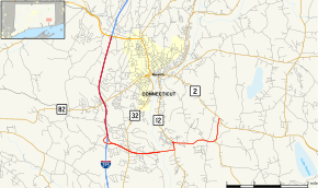
Map of New London County in southeastern Connecticut with Route 2A highlighted in red | ||||
| Route information | ||||
| Maintained by ConnDOT | ||||
| Length: | 9.91 mi (15.95 km) | |||
| Existed: | 1967 – present | |||
| Major junctions | ||||
| West end: |
| |||
| East end: |
| |||
| Location | ||||
| Counties: | New London | |||
| Highway system | ||||
| ||||

Route 2A is a state highway in the U.S. state of Connecticut. It is a 9.9-mile (15.9 km) mostly expressway alternate route of Route 2 that bypasses the downtown area of the city of Norwich and serves as the main access road to the Mohegan Sun casino.
Route description
Route 2A begins at the junction of I-395 and Route 2/Route 32 in Norwich. Route 2A travels south along I-395 for 3.7 miles (6.0 km) before separating as its own 2-lane freeway at I-395 Exit 9 in Montville. This independent freeway portion of Route 2A runs easterly for about 3.2 miles (5.1 km) with interchanges for Route 32 and Mohegan Sun Casino before crossing the Thames River on the Mohegan-Pequot Bridge into Preston and ending at Route 12. After turning north onto Route 12 for a brief overlap, it resumes its easterly course, meeting with Route 117 in the village of Poquetanuck. From here, Routes 2A and 117 continue north as a concurrency to Route 2 where both routes end.
History
When the highway and bridge opened in December 1967, motorists were charged a 15-cent toll. The toll plaza located at the west end of the Mohegan-Pequot Bridge was removed in 1980.[1]
Future
The Connecticut Department of Transportation announced in May 2013 that exit numbers on I-395 and Route 2A would be renumbered from the then-existing sequential-based system to mileage-based numbering; the numbers on I-395 were changed from June to November 2015, the Route 2A numbers by March 2016. The old exit numbers are posted above the "exit tab" for the mile-based numbers; the former exit numbers are scheduled to be removed in 2017 to help motorists adjust to the new exit numbering system during the transition period.
Exit list
Old (pre-2016) exit numbers are listed in parentheses. The entire route is in New London County.
| Location | mi | km | Exit | Destinations | Notes |
|---|---|---|---|---|---|
| Norwich | 0.00– 0.24 | 0.00– 0.39 | 13 (81) | Northern terminus of I-395 overlap. CT 2A uses I-395 exit numbers | |
| 2.44 | 3.93 | 11 (80) | |||
| Montville | 3.90 | 6.28 | 9 (79A) | Southern terminus of I-395 overlap | |
| 5.30 | 8.53 | 5 (1) | |||
| 6.39 | 10.28 | 6 (2) | Mohegan Sun Boulevard | Mohegan Sun | |
| Thames River | 6.64 | 10.69 | Mohegan-Pequot Bridge | ||
| Preston | 7.05 | 11.35 | Southern terminus of CT 12 overlap | ||
| 7.35 | 11.83 | Northern terminus of CT 12 overlap | |||
| 9.11 | 14.66 | Southern terminus of CT 117 overlap | |||
| 9.91 | 15.95 | Northern terminus of CT 117 overlap and of CT 117. Eastern terminus of CT 2A | |||
| 1.000 mi = 1.609 km; 1.000 km = 0.621 mi | |||||
† Current I-395 exit numbers are mileage-based.
References
External links
![]() Media related to Connecticut Route 2A at Wikimedia Commons
Media related to Connecticut Route 2A at Wikimedia Commons