Connecticut Route 3
| |||||||
|---|---|---|---|---|---|---|---|
 | |||||||
| Route information | |||||||
| Maintained by ConnDOT | |||||||
| Length: | 14.48 mi (23.30 km) | ||||||
| Existed: | 1941 (extended 1991) – present | ||||||
| Major junctions | |||||||
| South end: |
| ||||||
|
| |||||||
| North end: |
| ||||||
| Location | |||||||
| Counties: | Middlesex, Hartford | ||||||
| Highway system | |||||||
| |||||||

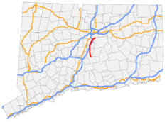
Route 3 is a 14.48-mile-long (23.30 km) route connecting Middletown to the Glastonbury-East Hartford town line. It passes through the towns of Cromwell, Rocky Hill, Wethersfield, and Glastonbury. The northernmost 3 miles (4.8 km) of Route 3 is an expressway that was originally intended for the cancelled Interstate 491.
Route description
Route 3 begins at Route 66 in Middletown, and is a secondary, minor arterial road for its first 11 miles (18 km) up to its interchange with Interstate 91 in Wethersfield. After crossing into Cromwell, it intersects Route 372, which offers access to Route 9 just east of the intersection. After overpassing Route 9, it continues north into Rocky Hill and overpasses Interstate 91 without an interchange (access is via West Street [SSR 411]). After a brief concurrency with Route 160, it crosses into Wethersfield, where it meets the eastern end of Route 287 and crosses over Route 99. After the Elm Street intersection, it becomes a freeway for the last 3.5 miles (5.6 km). After a partial interchange with Interstate 91 (no direct access to I-91 South from Route 3 North), it crosses the Connecticut River on the William H. Putnam Memorial Bridge into Glastonbury. The freeway has one exit for Main Street (via Glastonbury Boulevard northbound and Putnam Boulevard southbound) before ending at a trumpet interchange with the Route 2 freeway at the East Hartford town line. The last 0.75 miles (1.21 km) of Route 3 is the merging ramp from Route 3 northbound to Route 2 westbound.
History
1941
Route 3 was established in 1941. It originally ran from West Street/Berlin Road in Cromwell, which was part of Route 72 at the time (now Route 372), to the Silas Deane Highway (Route 99) in Wethersfield.
1958-1973 (I-491)
| |
|---|---|
| Location: | Hartford, Connecticut |
| Existed: | 1958–1973 |
In late 1958, as part of the planned Interstate 491 (a southeastern bypass of Hartford), a freeway from I-91 to Route 2, crossing the Connecticut River on the Putnam Memorial Bridge, was opened. The Route 3 designation was temporarily extended along this freeway pending completion of I-491. In 1973, I-491 was cancelled due to local opposition and the Route 3 designation along this freeway segment became permanent.
1991
In 1991, when the Route 9 freeway through Berlin and New Britain was completed, Route 72 was truncated to end at Route 9 in New Britain. The east–west portion of the old alignment of Route 72 was reassigned to an extended Route 372 (running along Berlin Road/West Street to end at Route 99 in Cromwell). The north–south portion of old Route 72 from Cromwell to Middletown (ending at Route 66) was reassigned to Route 3.
Junction list
| County | Location | mi | km | Destinations | Notes |
|---|---|---|---|---|---|
| Middlesex | Middletown | 0.00 | 0.00 | ||
| Cromwell | 3.37 | 5.42 | |||
| Hartford | Rocky Hill | 6.59 | 10.61 | ||
| 7.21 | 11.60 | Eastern terminus of CT 160 overlap | |||
| 7.40 | 11.91 | Western terminus of CT 160 overlap | |||
| Wethersfield | 10.21 | 16.43 | |||
| 10.37 | 16.69 | ||||
| 10.99 | 17.69 | Elm Street | At-grade intersection, Begin Expressway | ||
| 11.31 | 18.20 | No direct access Route 3 North to I-91 South | |||
| Connecticut River | 11.63– 12.09 | 18.72– 19.46 | Putnam Bridge | ||
| Glastonbury | 12.96– 13.27 | 20.86– 21.36 | Main Street – Glastonbury | Exits to Glastonbury Blvd (NB) and Putnam Blvd (SB) | |
| 13.51– 14.48 | 21.74– 23.30 | Route 2 exit 5D, trumpet interchange. Northern terminus of CT 3 | |||
1.000 mi = 1.609 km; 1.000 km = 0.621 mi
| |||||
References
External links
| Wikimedia Commons has media related to Connecticut Route 3. |