Connecticut Route 64
| ||||
|---|---|---|---|---|
|
Map of western Connecticut with Route 64 highlighted in red | ||||
| Route information | ||||
| Maintained by ConnDOT | ||||
| Length: | 8.14 mi[1] (13.10 km) | |||
| Existed: | 1932 – present | |||
| Major junctions | ||||
| West end: |
| |||
| East end: |
| |||
| Location | ||||
| Counties: | Litchfield, New Haven | |||
| Highway system | ||||
| ||||

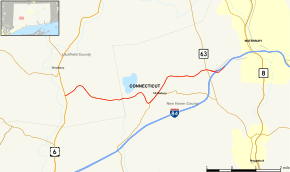
Route 64 is a Connecticut state highway connecting the towns of Woodbury and Waterbury via Middlebury.
Route description
Route 64 begins as Sherman Hill Road at an intersection with US 6 in the Pomeraug section of Woodbury (just south of the town center) and heads east towards Middlebury. After crossing the town line, the road becomes Middlebury Road. Route 64 soon meets and briefly overlaps Route 188 (for about half a mile) west of Middlebury center before continuing northeast then east through the Oronoke section of Middlebury, where it intersects with Route 63 (signed for Watertown and Naugatuck). Route 64 crosses into the city of Waterbury about 0.1 mi (0.16 km) east of the Route 63 junction and becomes Chase Parkway. After another 0.2 miles (0.32 km), Route 64 leaves Chase Parkway, continuing straight onto the eastbound I-84 Interchange 17 onramp. The last 0.5 miles (0.80 km) of Route 64 is along the onramp and it ends as it merges with eastbound I-84. Chase Parkway continues east of Route 64 for another 1.6 miles (2.6 km) into downtown Waterbury and is an unsigned state highway with designation State Road 845.[1]
History
The road linking Woodbury and Waterbury was originally laid out as a toll road in May 1823 and was known as the Woodbury and Waterbury Turnpike.[2] The Woodbury-Waterbury road was incorporated as part of New England Route 3 in 1922, which ran east–west across Connecticut and directly connected the cities of Danbury, Waterbury, Hartford, and Willimantic. In 1926, the U.S. Highway system was established and US 6 was co-signed along most of New England Route 3. For a few years between 1926 and 1929, the Woodbury to Waterbury route was signed as US 6. By 1930, US 6 was relocated to a more northerly alignment via Watertown, Thomaston, and Bristol. This left the Woodbury-Waterbury route signed only as Route 3. In the 1932 state highway renumbering, the New England Route 3 designation was deleted. Route 14 was created at the same time and incorporated the Woodbury-Waterbury route and continued eastward via Meriden, Middletown, and Willimantic to the Rhode Island state line in Sterling. In 1941, most of Route 14 (west of Willimantic) was re-designated as US 6A. In 1967, the US 6A designation was removed in Connecticut and broken into several smaller routes. Modern Route 64 is one of these routes that was created as a result of the renumbering of US 6A.[3][4]
Junction list
| County | Location | mi[1] | km | Destinations | Notes | ||
|---|---|---|---|---|---|---|---|
| Litchfield | Woodbury | 0.00 | 0.00 | ||||
| New Haven | Middlebury | 4.25 | 6.84 | Southern terminus of CT 188 overlap | |||
| 4.79 | 7.71 | Northern terminus of CT 188 overlap | |||||
| 7.31 | 11.76 | CT 63 south to I-84 WB | |||||
| Waterbury | 7.61 | 12.25 | SR 845 (Chase Parkway) | ||||
| 8.14 | 13.10 | I-84 Exit 17 westbound, partial interchange. Eastern terminus of CT 64 | |||||
| 1.000 mi = 1.609 km; 1.000 km = 0.621 mi | |||||||
Notes
The intersection with Route 63 in Middlebury is one of the most congested points in the Waterbury area.[5]
References
- 1 2 3 Connecticut State Highway Log Archived 2015-07-26 at WebCite
- ↑ It is sometimes erroneously referred to in some state documents as the "Woodbridge and Waterbury Turnpike".
- ↑ Connecticut Routes, Route 64
- ↑ Connecticut Routes, US 6A
- ↑ ConnDOT Traffic Log