Connecticut Route 87
| ||||
|---|---|---|---|---|
|
Map of eastern Connecticut with Route 87 highlighted in red | ||||
| Route information | ||||
| Maintained by ConnDOT | ||||
| Length: | 16.62 mi[1] (26.75 km) | |||
| Existed: | 1932 – present | |||
| Major junctions | ||||
| South end: |
| |||
|
| ||||
| North end: |
| |||
| Location | ||||
| Counties: | New London, Tolland | |||
| Highway system | ||||
| ||||

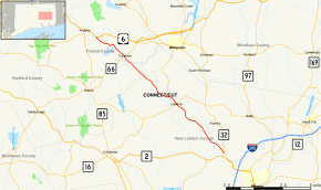
Route 87 is a Connecticut state highway running from Franklin to Andover, generally in a southeast-northwest direction. The route is part of the road connecting the towns of Norwich, Lebanon, Columbia, and Andover. Route 87 is a two-lane rural collector road for its entire length.
Route description
Route 87 begins as Norwich-Lebanon Road at an intersection with Route 32 in the southeast corner of the town of Franklin, just northwest of the Yantic neighborhood of Norwich. It heads northwest across the Susquetonscut Brook and railroad tracks, briefly crossing into Bozrah (for 0.18 miles), before re-entering Franklin. The road runs for another 3.5 miles (5.6 km) in the southwest part of Franklin then enters the town of Lebanon, where the road name becomes Trumbull Highway. Route 87 heads directly into the town center where it has a junction with Route 207. About a mile further, Route 289 splits off heading north towards Willimantic while Route 87 continues northwest towards Columbia. At the Columbia town center, it intersects with Route 66. North of the town center, Route 87 skirts the north shore of Columbia Lake before crossing into the town of Andover. Route 87 ends about half a mile from the town line at an intersection with US 6. Westbound US 6 continues directly into the Andover town center.[1]
Special designations
Route 87, over its entire length, is one of the last remaining sections of the Jonathan Trumbull Highway.[1][2]
History
The road between Norwich and Bolton Notch, through the town centers of Lebanon, Columbia, Andover, and Bolton, was chartered as a turnpike in October 1795, and was called the Hartford, New London, Windham, and Tolland County Turnpike. The toll road was in operation for about 40 years.
In 1922, when Connecticut first numbered its state highways, the route of the old turnpike was designated as State Highway 168. Modern Route 87 was established in 1932 as a renumbering of old State Highway 168 and originally ended in Bolton like the old turnpike, approximately at the current intersection of US 6 and US 44. In 1934, the Bolton Notch to Andover portion became part of U.S. Route 6A (later to become US 6) and Route 87 was truncated to its current northern end.[2]
Junction list
| County | Location | mi[1] | km | Destinations | Notes |
|---|---|---|---|---|---|
| New London | Franklin | 0.00 | 0.00 | ||
| Lebanon | 6.54 | 10.53 | |||
| 7.46 | 12.01 | ||||
| Tolland | Columbia | 13.29 | 21.39 | ||
| Andover | 16.62 | 26.75 | Northern terminus of CT 87 | ||
| 1.000 mi = 1.609 km; 1.000 km = 0.621 mi | |||||
References
- 1 2 3 4 Connecticut State Highway Log Archived 2015-07-26 at WebCite
- 1 2 Connecticut Routes, Route 87