Columbia, Connecticut
| Columbia, Connecticut | ||
|---|---|---|
| Town | ||
| ||
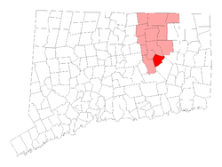 Location within Tolland County, Connecticut | ||
| Coordinates: 41°41′28″N 72°18′26″W / 41.69111°N 72.30722°WCoordinates: 41°41′28″N 72°18′26″W / 41.69111°N 72.30722°W | ||
| Country | United States | |
| State | Connecticut | |
| NECTA | Hartford | |
| Region | Windham Region | |
| Incorporated | 1804 | |
| Government | ||
| • Type | Selectman-town meeting | |
| • First selectman | Carmen L. Vance (R) | |
| • Selectmen |
Steven Everett (R) Robert Bogue (R) Robert Hellstrom (D) William O'Brien (D) | |
| Area | ||
| • Total | 22.0 sq mi (57.0 km2) | |
| • Land | 21.4 sq mi (55.3 km2) | |
| • Water | 0.6 sq mi (1.6 km2) | |
| Elevation | 551 ft (168 m) | |
| Population (2000) | ||
| • Total | 4,971 | |
| • Density | 232.8/sq mi (89.9/km2) | |
| Time zone | EST (UTC-5) | |
| • Summer (DST) | EDT (UTC-4) | |
| ZIP code | 06237 | |
| Area code(s) | 860 | |
| FIPS code | 09-16400 | |
| GNIS feature ID | 0213411 | |
| Website |
www | |
Columbia is a town in Tolland County, Connecticut, United States. The population was 4,971 at the 2000 census. Originally a part of Lebanon, known as the North Society or Lebanon's Crank,[1] Columbia was incorporated in May, 1804. Columbia gets its name from the American ballad Hail, Columbia. Columbia offers prekindergarten through 8th grade education in town at Horace W. Porter School, while high school students have a choice of attending four nearby high schools (Bolton High School, E. O. Smith High School, Windham High School and Windham Technical High School, part of the Connecticut Technical High School System).
Geography
According to the United States Census Bureau, the town has a total area of 22.0 square miles (57 km2), of which, 21.4 square miles (55 km2) of it is land and 0.6 square miles (1.6 km2) of it (2.78%) is water.
Demographics
| Historical population | |||
|---|---|---|---|
| Census | Pop. | %± | |
| 1850 | 876 | — | |
| 1860 | 832 | −5.0% | |
| 1870 | 891 | 7.1% | |
| 1880 | 757 | −15.0% | |
| 1890 | 740 | −2.2% | |
| 1900 | 655 | −11.5% | |
| 1910 | 646 | −1.4% | |
| 1920 | 706 | 9.3% | |
| 1930 | 648 | −8.2% | |
| 1940 | 853 | 31.6% | |
| 1950 | 1,327 | 55.6% | |
| 1960 | 2,163 | 63.0% | |
| 1970 | 3,129 | 44.7% | |
| 1980 | 3,386 | 8.2% | |
| 1990 | 4,510 | 33.2% | |
| 2000 | 4,971 | 10.2% | |
| 2010 | 5,485 | 10.3% | |
| Est. 2014 | 5,454 | [2] | −0.6% |
As of the census[4] of 2000, there were 4,971 people, 1,864 households, and 1,463 families residing in the town. The population density was 232.8 people per square mile (89.9/km²). There were 1,988 housing units at an average density of 93.1 per square mile (35.9/km²). The racial makeup of the town was 97.43% White, 0.38% African American, 0.08% Native American, 0.70% Asian, 0.06% Pacific Islander, 0.56% from other races, and 0.78% from two or more races. Hispanic or Latino of any race were 1.69% of the population.
There were 1,864 households out of which 36.2% had children under the age of 18 living with them, 68.1% were married couples living together, 7.4% had a female householder with no husband present, and 21.5% were non-families. 17.3% of all households were made up of individuals and 6.8% had someone living alone who was 65 years of age or older. The average household size was 2.65 and the average family size was 3.01.
In the town the population was spread out with 26.2% under the age of 18, 4.6% from 18 to 24, 30.3% from 25 to 44, 28.1% from 45 to 64, and 10.9% who were 65 years of age or older. The median age was 40 years. For every 100 females there were 95.8 males. For every 100 females age 18 and over, there were 94.7 males.
The median income for a household in the town was $70,208, and the median income for a family was $77,665. Males had a median income of $51,250 versus $37,685 for females. The per capita income for the town was $29,446. About 1.8% of families and 4.2% of the population were below the poverty line, including 6.0% of those under age 18 and 5.3% of those age 65 or over.
| Voter Registration and Party Enrollment as of October 25, 2005[5] | |||||
|---|---|---|---|---|---|
| Party | Active Voters | Inactive Voters | Total Voters | Percentage | |
| Democratic | 1,113 | 65 | 1,178 | 31.68% | |
| Republican | 765 | 32 | 797 | 21.44% | |
| Unaffiliated | 1,616 | 125 | 1,741 | 46.83% | |
| Minor Parties | 2 | 0 | 2 | 0.05% | |
| Total | 3,496 | 222 | 3,718 | 100% | |
On the National Register of Historic Places
Notable residents past and present
- Anthony Gregorc, psychologist. Currently resides in Columbia.
- Dwight Loomis (1821–1903), US Congressman and Connecticut Supreme Court judge.
- Edith G. Prague (1925–present) Connecticut State Senator for the 19th District.(active 1994-2012)
References
- ↑ "History of Lebanon, CT". Retrieved 1 August 2012.
- ↑ "Annual Estimates of the Resident Population for Incorporated Places: April 1, 2010 to July 1, 2014". Retrieved June 4, 2015.
- ↑ "Census of Population and Housing". Census.gov. Archived from the original on May 11, 2015. Retrieved June 4, 2015.
- ↑ "American FactFinder". United States Census Bureau. Archived from the original on 2013-09-11. Retrieved 2008-01-31.
- ↑ "Registration and Party Enrollment Statistics as of October 25, 2005" (PDF). Connecticut Secretary of State. Archived from the original (PDF) on 2006-09-23. Retrieved 2006-10-02.
External links
- Town Web site
- Windham Technical High School
- Horace W. Porter School, Grades Pre-K thru 8
- E. O. Smith High School
- Windham High School
- Bolton High School
- Saxton B. Little Free Library, Columbia's public library
- Mystic Country: The Eastern Regional Tourism District
Municipalities and communities of Tolland County, Connecticut, United States | ||
|---|---|---|
| Towns |  | |
| Other communities | ||
