Conococheague Formation
| Conococheague Formation Stratigraphic range: Cambrian | |
|---|---|
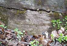
 Etched section of rock from the Conococheague Formation from Washington County, Maryland (dolomite is lighter than the limestone) | |
| Type | sedimentary |
| Sub-units | Big Spring Station Member |
| Underlies | Beekmantown dolomite |
| Overlies | Elbrook dolomite[1] |
| Lithology | |
| Primary | Limestone |
| Other | Dolomite, sandstone |
| Location | |
| Region | Appalachian Basin of eastern North America |
| Extent | Maryland, Pennsylvania, Virginia, West Virginia |
| Type section | |
| Named for | Conococheague Creek[2] |
| Named by | G. W. Stose, 1908 |
The Conococheague Formation is a mapped Appalachian bedrock unit of Cambrian age, consisting primarily of limestone and dolomite. It occurs in central Maryland, southern and central Pennsylvania, northern Virginia and easternmost West Virginia.[3]
Description
Depositional environment
The depositional environment of the Conococheague was most likely shallow marine to tidal on a carbonate platform.
Notable Exposures
The type section is located at Scotland in Franklin County, Pennsylvania (northeast of Chambersburg).[2]
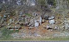
Accessible outcrops occur along various roadcuts and waterways in the area, including roadcuts near mile marker 20 of I-70 near Hagerstown, Maryland. The bedding at this site is nearly vertical, with the strike nearly perpendicular to the highway, and thus one can easily walk up and down the sections.
The Conococheague also forms dramatic, 100-foot cliffs along the Potomac River upstream of Shepherdstown, West Virginia (northwest of Harpers Ferry), where entrenched meanders expose mile-long sections of tilted Conococheague strata.[4] These may be easily seen from the towpath trail of the Chesapeake and Ohio Canal National Historical Park along the Maryland bank of the Potomac. In Shepherdstown itself, the top of a Conococheague cliff provides the setting for the monument to steamboat-inventor James Rumsey.
Fossils
Conodonts are present in the Conococheague.[5]
Thrombolites and the possible chiton Matthevia are present in the Boxley Blue Ridge Quarry in Bedford County, Virginia.[6][7]
Age
Relative-age dating of the Conococheague places it in the Upper Cambrian period.
References
- ↑ King, P.B., 1950, Geology of the Elkton area, Virginia: U.S. Geological Survey Professional Paper, 230, 82 p. http://pubs.er.usgs.gov/pubs/pp/pp230
- 1 2 Stose, G.W., 1908, The Cambro-Ordovician limestones of the Appalachian Valley in southern Pennsylvania: Journal of Geology, v. 16, p. 698-714.
- ↑ Conococheague Formation on the United States Geological Survey website
- ↑ Means, John. 2010, Roadside Geology of Maryland, Delaware, and Washington, D.C. Mountain Press, Missoula, Montana. x+346 pp.
- ↑ Orndorff, R.C., 1988, Latest Cambrian and earliest Ordovician conodonts from the Conococheague and Stonehenge limestones of northwestern Virginia, IN Sando, W.J., ed., Shorter contributions to paleontology and stratigraphy: U.S. Geological Survey Bulletin, 1837-A, p. A1-A18.
- ↑ Conococheague Formation, Part 2, Updates from the Vertebrate Paleontology Lab, Virginia Museum of Natural History
- ↑ Unusual Cambrian Thrombolites from the Boxley Blue Ridge Quarry, Bedford County, Virginia by A. C. Dooley, Jr., JEFFERSONIANA, Number 19, 10 January 2009, Virginia Museum of Natural History
| Preceded by Proterozoic Eon | Phanerozoic Eon | |||||||||||
|---|---|---|---|---|---|---|---|---|---|---|---|---|
| Paleozoic Era | Mesozoic Era | Cenozoic Era | ||||||||||
| Cambrian | Ordovician | Silurian | Devonian | Carboniferous | Permian | Triassic | Jurassic | Cretaceous | Paleogene | Neogene | 4ry | |