Constitution Street
Coordinates: 55°58′23″N 3°10′06″W / 55.97306°N 3.16833°W

Constitution Street is a thoroughfare in Leith, Edinburgh, Scotland. It runs north from the junction of Leith Walk, Great Junction Street and Duke Street to Leith docks.
The street takes its name from Constitution Hill, which stood on the site of the current Assembly Rooms.[1] The road was only completed in 1800, at that time being built as a bypass from Bernard Street to Leith Walk, avoiding the crowded and twisting medieval streets of old Leith. The street at that time was causewayed, rising around two metres above natural ground level. Buildings which predate this now have their original fine ground floor rooms buried at basement level.
Constitution Street was to form part of the Edinburgh Trams network and much preparatory work was carried out but the Leith section of the project has been abandoned.
Notable events
On 9 January 1823 the last two men executed for piracy in Scotland were hanged at the north end of the street (near what is now Tower Street). The two men were Peter Heaman from Sweden and Francois Gautiez from France. They were found guilty in the summer of 1822 of capturing the brig "Jane", en route from Gibraltar to Brazil, killing its master and stealing 38,000 Spanish dollars. The crowd witnessing this event was given as a huge 40 to 50,000 persons. One account says their bodies were afterwards awarded to Dr Robert Knox for dissection.[2] A second account says they were buried where executed. Two bodies were discovered during an archaeological dig at the north end of the street in approximately the correct area in the summer of 2000, possibly validating the latter claim.
Notable buildings and landmarks

Starting at the north end and working southwards:
The existing Dalton Scrapyard is enclosed by 17th century walls, including a lintel inscribed with three anchors. The former Corn Exchange has a very fine frieze depicting "putti" gathering corn, getting drunk, and loading the corn onto ships. This building is now a design studio.
The site opposite, now modern flats over shops, held the main salt warehouse, serving most of eastern Scotland into the 19th century.
The street widens out at Bernard Street, where there is a fine statue of Robert Burns.
South of Bernard Street, the most notable building is the classical Assembly Rooms, the former Leith Exchange building. The northern part of this building is simply a tenement tacked on and designed as per the main halls to make them look bigger and more impressive. The little two storey building next door, with Doric key design, was built as a Post Office c.1810, but is now residential. The office building adjacent dates from 1805 but the two northern bays were only added in 1930. This too is now converted to flats (2009).
Opposite these stand mainly tenemental properties. The very tall one on the corner has very intact Georgian shopfronts, and is entitled the Waterloo buildings, as it was built in 1815, the year of the famous victory. The next tenement dates from 1760, and is one with a buried ground floor (see above). Confusingly it bears two dates: 1886 and 1986, marking restoration dates rather than construction. Townscape breaks down a little but is cheered up by the interjection of the Port O'Leith Bar infamously portrayed as the "Sunshine Bar" in the gritty novel Trainspotting.
Mitchell Street to the east has been transformed. Up until the 1980s it was a bustling commercial street, with many listed buildings including one with a cast-iron frontage. It was described as "the best industrial street in Scotland"[3]
The first building beyond Mitchell Street was a Post Office, built to replace that to the north in 1875. The next building, black with age, belies its former importance. This was the offices to Leith Leadworks, which lay behind, and up until 1920 provided 90% of all Scotland's lead (including sheet, pipe, and pellet shot). The upper level (now concreted over) had an ornamental carved frieze, and the building had several stone urns (those copied on the adjacent building survive, the originals do not).[4] The next building was clearly built as a church. It started life as a Georgian box chapel in 1770, just outside the town wall.[5] Its original entrance is still visible on the south wall as are the silhouettes of the original windows. The current front, tower and two flanking lodges (only one of which survives) were built in 1843 by David Rhind.[6] The "lodges" were church-run schools: one for infants and one for juveniles.[7]

Then comes a very imposing building: Leith Police Station, built as Leith Town Hall in 1827 by R & R Dickson.[8] This still contains the Victorian debating chamber of 1864, unchanged since that date. Attaching the north side, facing onto Constitution Street, is the jail. This still has its original interior. The windows on the outside belie this use. Only on inspection does one perceive that the windows are tapered in, and therefore could not operate. This is correct; They are dummy windows, even to the extent of having dummy venetion blinds created inside (in concrete). The three windows cover 4 cells, which clearly would not be allowed windows. Around the corner an early bit of facade retention: the Police station took over a terrace of Georgian houses in 1864 and incorporated them into the complex. The interior and entrance door date from 1868, everything else dates from c.1810.
Opposite on Constitution Street a fine villa of 1760 has been somewhat cannibalised. Its ground floor was previously far taller in relation to the road, but the raising of the road has truncated its form. The existing ground floor dates from c.1860 and was presumably created to iron out the problems of floor levels.
Queen Charlotte Street to the Foot of the Walk
Queen Charlotte Street, formerly Charlotte Street but renamed in 1967, is named after Queen Charlotte, consort to King George III.
The fine (but black) tenement on the south side of that street dates from 1805. Stylistically it is very similar to Baxter's Place at the head of Leith Walk and is therefore presumed to be by the same architect/builder, John Baxter.
Opposite, the pub now called "The Compass" was previously "The Copper Bowl", a pun referring to its use by the policemen. It was also called "Slammers" in the 1990s and early 2000s.
Back to the east side, was a low Victorian building, with another pun: the "Leith Lynx" bar/restaurant being a play on "Leith Links". The hinterland of this building housed one of Leith's brothels, which were relatively common until the gentrification of the area in the 1980s.
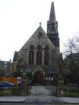
Opposite some good warehouses, converted to flats, then a pair of churches. To the west, St. Mary's Star of the Sea, Leith's principal Roman Catholic church. This evolved on the garden ground of Lord Balmerino, whose house survived on the Kirkgate until swept away in the 1950s, unnoticed by the planners.[9] A convent and school were also built (hiding to the rear). The school, visible from Queen Charlotte Street is now flatted. It is hard to now discern the previous rooftop playground, forced on the property due to lack of space. The church is of many different dates but disguises this well. The original is by E.W.Pugin and J.A.Hansom, and dates from 1852.
Roughly opposite, and showing that Leith used only the best architects of the period, St.James was by Giles Gilbert Scott, built in 1862. Its church function decanted to the far smaller hall to its east in the 1970s. The building has been somewhat underused ever since. Its huge stone spire (truncated in 1977) is visible over a very wide area.
Immediately opposite St.James, the offices of Port of Leith Housing Association, a prime mover in the revitalisation of the area. This is an interesting modern building, designed in 2000 by the Lee Boyd Partnership. One of Edinburgh'smost distinctive modern buildings it includes a stone tower (holding the fire escape), a graded series of timber boards over the whole frontage, giving a venetian blind effect, and rooftop Japanese water gardens. It also has an underground car park.
The white building two to the south (132)is one of the earliest on the street, dating from 1740. It was rebuilt when the road was causewayed, adding an extra storey (still visible) to replace the lost storey now at basement level. Although looking plain, it has several magnificent rooms within, largely from its remodelling in 1800.
Nos.134-138 now converted to flats were built as a small townhouse c.1780, and largely operated as offices. In its last guise before conversion it operated as the hugely unpopular Sheriff Officers quarters, operating the retrieval of owed monies for the Community Charge usually called the "Poll Tax". This inevitably led to several attacks on the building, thankfully none serious. The north wing is cleverly balanced on the south by what appears to be a south wing, but which in reality are a series of burial vaults belonging to the adjacent churchyard.
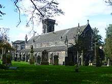
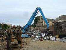
The churchyard belongs to South Leith Parish Church a building of great antiquity, and covered by a separate article. The churchyard was only used for burial from the mid 17th century, earlier interments being inside the church, beneath the parishioners usual seating position (or threaded in the rafters if you had a balcony position). The churchyard is split into trades: maltmen (brewers); porters; mariners etc. reflecting the layout of altars within the church in pre-Reformation days. In 2009 an excavation linked to the creation of the Edinburgh tram unearthed several bodies just outside the churchyard wall[10] A planning application to demolish the wall in its entirety was approved in January 2012 following no public comment despite this very radical proposition. This was necessitated by the proposed tram works, which was considered to threaten the stability of the wall. Demolition is required in order to provide a good new foundation to the wall (which is to be then rebuilt). However, this work will also clearly require the exhumation of hundreds of bodies within the churchyard, and is a complex matter in terms of Scottish burial law.[11] The irony of this planning consent is that it post-dated the abandonment of the Leith section of the Edinburgh Tram Project in June 2011.
On the east side of the street a good row of tenements and warehouses. The only new building is the alien brick Old Persons Care Home, which replaced a wool warehouse, burnt down in 1978. The remnants of a Georgian chapel and a warehouse wrapping over it are still visible at the south end of this building.
At the end of the street, a former cinema is now a Wetherspoons. The building opposite was Woolworths and is now a British Heart Foundation charity furniture shop. The space between these was proposed as a tram stop for the Edinburgh Tram until this section was dropped from the scheme.
References
- ↑ Plan of Leith 1777
- ↑ Grant, p. 243.
- ↑ Industrial Arcaelogy In Scotland
- ↑ Stephen Dickson, private photograph collection
- ↑ Plan of Leith 1777
- ↑ Buildings of Scotland; Edinburgh, by Colin McWilliam
- ↑ 1852 Ordnance Survey map annotation
- ↑ Dictionary of Scottish Architects: Dickson
- ↑ E.J. Macrae plan for rebuilding of Leith 1945
- ↑ http://edinburghnews.scotsman.com/edinburghtransportplans/Tram-workers-unearth-human-remains.5572004.jp.
- ↑ City of Edinburgh: Planning Applications , November 2011
Bibliography
- Grant, James A. Cassell's Old and New Edinburgh: Its History, its people and its places. VI. London: Cassell & Company.