Conway Summit
| Conway Summit | |
|---|---|
|
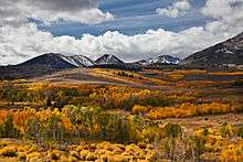
U.S. Highway 395 climbing north side of Conway Summit | |
| Elevation | 8,143 ft (2,482 m) |
| Traversed by |
|
| Location | Mono County, California, United States |
| Coordinates | 38°05′17″N 119°10′55″W / 38.08806°N 119.18194°WCoordinates: 38°05′17″N 119°10′55″W / 38.08806°N 119.18194°W |
| Topo map | USGS Lundy |

Conway Summit (el. 8,143 feet (2,482 m)) is a mountain pass in Mono County, California. It is traversed by U.S. Highway 395, which connects Bridgeport and the East Walker River on the north side of the pass to Mono Lake and Lee Vining to the south.[1][2] It marks the highest point on U.S. 395, which also traverses high passes at Deadman Summit and Devil's Gate Pass.[3]
Conway Summit is named after John Andrew Conway, a settler in the area in 1880.[3][4] Geographically, it was formed from an upland plateau by the sinking of the land in the Mono basin area.[5] The Sawtooth Ridge of the eastern Sierra Nevada, topped by 12,279-foot (3,743 m) Matterhorn Peak, rise to the west of the pass; Green Creek and Virginia Lakes, in the Sierra Nevada to the west of the pass, are two local destinations for fishing, camping and aspen trees. The Bodie Hills and the infamous Bodie ghost town lie to the east.
References
- ↑ Conway Summit, Mono County, California. Eastern Mojave Vegetation (and a few other things), Tom Sweich.
- ↑ U.S. Geological Survey Geographic Names Information System: Conway Summit.
- 1 2 US 395, Part 8: Mono County (Mono Lake to Bridgeport), Floodgap Roadgap.
- ↑ Durham, David L. (1998), California's Geographic Names: A Gazetteer of Historic and Modern Names of the State, Quill Driver Books, p. 1155, ISBN 978-1-884995-14-9.
- ↑ Easterbrook, Don J. (2003), Quaternary geology of the United States: INQUA 2003 field guide volume, Geological Society of America, p. 300, ISBN 978-94-592-0504-4.