Cookes Range
| Cookes Range | |
|---|---|
|
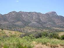
Eastern side of Cookes Range | |
| Highest point | |
| Peak | Cookes Peak (Cookes Range) |
| Elevation | 8,408 ft (2,563 m) |
| Coordinates | 32°32′10″N 107°43′54″W / 32.5360°N 107.7316°WCoordinates: 32°32′10″N 107°43′54″W / 32.5360°N 107.7316°W |
| Dimensions | |
| Length | 17 mi (27 km) N-S |
| Width | 8 mi (13 km) |
| Geography | |
 Cookes Range Cookes Range in New Mexico | |
| Country | United States |
| State | New Mexico |
| Region | ((northwest)-Chihuahuan Desert) |
| County | Luna |
| Settlement |
Deming Nutt, Lake Valley |
| Borders on |
Whitehorse Mountain-NW Mimbres Mountains-N Good Sight Mountains-ESE Deming, NM & Florida Mtns-S |
| Topo map | USGS Massacre Peak |
The Cookes Range (Cooke's Range, Cooks Range or Cook's Range) is a small, 17-mi (27 km) long[1] mountain range in northern Luna County, New Mexico, which extends slightly north into southeastern Grant County. The range is a southern continuation of the Mimbres Mountains, itself the southeast portion of the extensive north-south running Black Range. The Cooks Range is surrounded by lower elevation areas of the northwest Chihuahuan Desert.
Description
Cookes Range is about 17 mi long, and about 8 mi at its widest. The range is a basin and range north-south trending uplift with a center-north section intruded by granodiorite which forms Cookes Peak, 8,408 feet (2,563 m).[2] Cookes Peak is at the head of OK Canyon, which exits the range eastwards.[3] South of OK Canyon is a transverse ridgeline, across the range west to east, named Rattlesnake Ridge. One other larger peak occurs in the mountains and hills in the southern part of the range, Massacre Peak, at 5,667 feet (1,727 m). Other outlying lower elevation hills occur, east and west, in the north section, as the Cookes Range merges into the lower elevations of the Mimbres Mountains section of the Black Range.
History
The range was named after its prominent peak, which in turn was named after Captain Philip St. George Cooke of the Mormon Battalion.[4][5] Cookes Spring was a station on the Butterfield Trail.
Fort Cummings (1863–1873, 1880–1886), located in the southeastern foothills of the range near Cookes Spring was established to restrict Apache raiding.[6][7]
Silver was discovered in the range north of Cooks Peak in 1876, and the Cooks Peak Mining District was established in 1880. Silver, lead, and zinc were mined there until 1967.[2][8]
Environment and ecology
The higher elevations of the range are pinon-juniper shrublands habitat which gives way to Chihuahuan desert in the foothills. The Cookes Range Wilderness Study Area is located in the range.[9]
See also
References
- ↑ New Mexico Atlas & Gazetteer, DeLorme, c. 2009, p. 44-45.
- 1 2 Kelley, Shari A. (14 September 2009). "Cookes Peak". New Mexico Bureau of Geology and Mineral Resources. Archived from the original on 10 June 2010.
- ↑ New Mexico Atlas & Gazetteer, p. 45.
- ↑ Sherman, James E.; Sherman, Barbara H. (1975). Ghost Towns and Mining Camps of New Mexico. Norman, Oklahoma: University of Oklahoma Press. p. 56–57. ISBN 978-0-8061-1066-0.
- ↑ Julyan, Robert Hixson (2006). The Mountains of New Mexico. Albuquerque, New Mexico: University of New Mexico Press. p. 246. ISBN 978-0-8263-3516-6.
- ↑ Julyan 1975, p. 248
- ↑ "Cookes Peak-Fort Cummings, Luna and Hidalgo County, New Mexico". Survey New Mexico. Archived from the original on 18 May 2010.
- ↑ "Cooks Peak District (Cooke's Peak District), Luna Co., New Mexico, USA". The mineral and locality database (mindat.org).
- ↑ "Cookes Range Wilderness Study Area". myfishmaps.com.
External links
Peaks
- "Cookes Peak, Contiguous States US 2,000 ft Prominence List". Loj Lists of Peaks.
Cookes Range
- "Cookes Range Wilderness Study Area". myfishmaps.com.
- NMBGMR, Bureau of Geology and Mineral Resources, Cookes Peak, Cookes Range, maps & photo galley