Cordillera Oriental (Colombia)
| Cordillera Oriental (Eastern Ranges) | |
|---|---|
 | |
| Highest point | |
| Peak | Ritacuba Blanco [1] |
| Elevation | 5,410 m (17,750 ft) |
| Dimensions | |
| Length | 1,200 km (750 mi) northeast–southwest |
| Area | 144,252 km2 (55,696 sq mi) |
| Geography | |
| Country | Colombia |
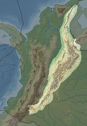
The Cordillera Oriental (English: Eastern Ranges) is the widest of the three branches of the Colombian Andes. The range extends from south to north dividing from the Colombian Massif in Huila Department to Norte de Santander Department where it splits into the Serranía del Perijá and the Cordillera de Mérida in Venezuela. The highest peak is Ritacuba Blanco at 5,410 m (17,750 ft) in the Sierra Nevada del Cocuy.
Geography
The western part of the Cordillera Oriental belongs to the Magdalena River basin, while the eastern part includes the river basins of the Amazon River, Orinoco River, and Catatumbo River. Within it, the Altiplano Cundiboyacense and the Sierra Nevada del Cocuy (with the only snowy peaks in this mountain range) stand out.
Protected areas
- PNN Catatumbo Barí
- PNN Cordillera de los Picachos
- Cueva de los Guácharos
- Chingaza Natural National Park
- Parque nacional natural Pisba
- Yariguíes National Park
- Sierra Nevada del Cocuy
- Parque nacional natural Sumapaz
- Tamá National Natural Park
- Los Estoraques Unique Natural Area
- Santuario de fauna y flora Guanenta Alto Río Fonce
- Lake Iguaque
See also
 Geography of Colombia
 Altiplano Cundiboyacense, Bogotá savanna, Tenza Valley
 Cordillera Central, Occidental, Andean Region
References
- ↑ "Cordillera Oriental (Colombia)". Retrieved 20 February 2013.
Mountain Ranges of Colombia | ||||||||||||||||
|---|---|---|---|---|---|---|---|---|---|---|---|---|---|---|---|---|
| Colombian Andes |
| .svg.png) | ||||||||||||||
| Isolated Ranges | ||||||||||||||||
This article is issued from Wikipedia - version of the 12/4/2016. The text is available under the Creative Commons Attribution/Share Alike but additional terms may apply for the media files.