Altiplano Cundiboyacense
| Altiplano Cundiboyacense | |
| Plateau | |
 | |
| Country | |
|---|---|
| States | Cundinamarca, Boyacá |
| Part of | Andes |
| Cities | Bogotá, Tunja, Sogamoso, Duitama |
| River | Bogotá, Chicamocha |
| Elevation | 2,600 m (8,530 ft) |
| Capital | Bogotá |
| Highest point | |
| - elevation | 3,000 m (9,843 ft) |
| Lowest point | |
| - elevation | 2,000 m (6,562 ft) |
| Geology | Paleozoic-Holocene |
| Orogeny | Eastern Ranges, Andes |
| Timezone | Colombia Standard Time (UTC-5) |
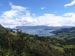
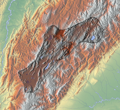 Topography and outline of the Altiplano Cundiboyacense
| |

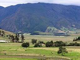
The Altiplano Cundiboyacense is a high plateau located in the Eastern Cordillera of the Colombian Andes covering parts of the departments of Cundinamarca and Boyacá. The altiplano corresponds to the ancient territory of the Muisca. The Altiplano Cundiboyacense comprises three distinctive flat regions; the Bogotá savanna, the valleys of Ubaté and Chiquinquirá, and the valleys of Duitama and Sogamoso. The average altitude of the altiplano is about 2,600 metres (8,500 ft) above sea level but ranges from roughly 2,000 metres (6,600 ft) to 3,000 metres (9,800 ft).
Etymology
Altiplano in Spanish means "high plain" or "high plateau", the second part is a combination of the departments Cundinamarca and Boyacá.
Limits
The limits of the Altiplano are not strictly defined. The high plateau is enclosed by the higher mountains of the Eastern Ranges, with the Sumapaz mountains in the south and Chingaza to the east. The Tenza Valley is located to the east of the Altiplano and the Chicamocha Canyon is situated to the north .
History
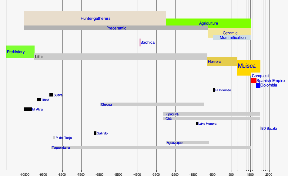
The earliest evidence of inhabitation of the Altiplano Cundiboyacense has been found in El Abra, near Zipaquirá at 12,400 ± 160 years BP.[1] Other ancient preceramic sites are Tibitó with an estimated age of 11,740 +/- 110 years BP and Tequendama dated at 10,920 ± 260 years BP.[1] In the earliest ages of human population prehistoric animals as the Cuvieronius, Haplomastodon and Equus amerhippus were living on the Altiplano.[2]
The ages between 3000 and 1000 years before present corresponds to the Herrera Period, and the era between 1000 BP and 1537, the year of the Spanish conquest, to the Muisca Confederation.[1]
Present-day, due to the large population and agriculture of the Altiplano, the original vegetation is at risk.[3]
Rock art
Various archaeological sites with petroglyphs or pictographs have been discovered on the Altiplano Cundiboyacense, among others in Bojacá, Bogotá, Chía, Usme, Cogua, Cota, Facatativá, Nemocón, Madrid, Mosquera, Sáchica, Sibaté, Soacha, Subachoque, Suesca, Tenjo, Tocancipá, Zipacón, Zipaquirá.[4]
Timeline of inhabitation
| Timeline of inhabitation of the Altiplano Cundiboyacense, Colombia | |
 |
 .png) |
Subdivision
• Duitama-Sogamoso Valley
• Ubaté-Chiquinquirá Valley
• Bogotá savanna
The Altiplano is subdivided into three major valleys, from northeast to southwest:
- Duitama-Sogamoso Valley
- Ubaté-Chiquinquirá Valley
- Bogotá savanna
Cities
Most important city of the Altiplano Cundiboyacense is the Colombian capital Bogotá. Other cities are, from northeast to southwest:
- Sogamoso
- Duitama
- Chiquinquirá
- Villa de Leyva
- Tunja
- Ubaté
- Suesca
- Tocancipá
- Zipaquirá
- Cajicá
- Chía
- Facatativá
- Soacha
Hydrology


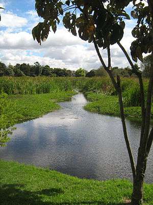
The Altiplano Cundiboyacense hosts a number of rivers and lakes.
Rivers
- Bogotá River
- Chicamocha River
- Funza River
- Sogamoso River
- Suárez River
- Ubaté River
Lakes
Natural
- Lake Tota, largest lake of Colombia
- Lake Fúquene
- Lake Guatavita
- Lake Herrera
- Lake Iguaque
- Siecha Lakes
- Lake Suesca
Artificial
- La Copa Reservoir
- El Muña Reservoir
- Neusa Reservoir
- San Rafael Reservoir
- Sisga Reservoir
- Lake Sochagota
- Tominé Reservoir
- Lake Herrera (since 1973)
Waterfalls
Wetlands
- Wetlands of Bogotá
- El Burro
- Capellanía
- La Conejera
- Córdoba
- Guaymaral y Torca
- Jaboque
- Maiporé
- Santa María del Lago
- Techo
- Tibabuyes
- Tibanica
- La Vaca
Climate
The average temperature on the Altiplano Cundiboyacense is 14 °C, ranging from 0 °C to 24 °C. The dryest months of the year are from December to March, while rain is more common in April, May, September, October and November. From June to August strong winds are present. Hail is common on the Altiplano.[5]
See also
References
- 1 2 3 Botiva Contreras, 1989
- ↑ Cardale de Schrimpff, 1985
- ↑ Calvachi Zambrano, 2012
- ↑ (Spanish) Petroglyphs on the Altiplano Cundiboyacense
- ↑ (Spanish) Climates of various cities of Colombia
Bibliography
- Botiva Contreras, Álvaro. 1989. Colombia Prehispánica - La Altiplanicie Cundiboyacense - Prehispanic Colombia - the Altiplano Cundiboyacense - V. Biblioteca Luís Ángel Arango. Accessed 2016-07-08.
- Calvachi Zambrano, Byron. 2012. Los ecosistemas semisecos del altiplano cundiboyacense, bioma azonal singular de Colombia, en gran riesgo de desaparición - The semi-arid ecosystems of the Altiplano Cundiboyacense, bioma of Colombia, at great risk of disappearance. Mutis 2. 26-59. Accessed 2016-07-08.
- Cardale de Schrimpff, Marianne. 1985. Ocupaciones humanas en el Altiplano Cundiboyacense - Human occupations on the Altiplano Cundiboyacense. Biblioteca Luís Ángel Arango. Accessed 2016-07-08.