Cordova Municipal Airport
| Cordova Municipal Airport | |||||||||||||||
|---|---|---|---|---|---|---|---|---|---|---|---|---|---|---|---|
 | |||||||||||||||
| IATA: CKU – ICAO: none – FAA LID: CKU | |||||||||||||||
| Summary | |||||||||||||||
| Airport type | Public | ||||||||||||||
| Owner | State of Alaska DOT&PF - Northern Region | ||||||||||||||
| Serves | Cordova, Alaska | ||||||||||||||
| Built | 1941 | ||||||||||||||
| Elevation AMSL | 12 ft / 4 m | ||||||||||||||
| Coordinates | 60°32′38″N 145°43′36″W / 60.54389°N 145.72667°WCoordinates: 60°32′38″N 145°43′36″W / 60.54389°N 145.72667°W | ||||||||||||||
| Map | |||||||||||||||
 CKU Location of airport in Alaska | |||||||||||||||
| Runways | |||||||||||||||
| |||||||||||||||
| Statistics (2005) | |||||||||||||||
| |||||||||||||||
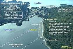
Cordova Municipal Airport (IATA: CKU, FAA LID: CKU) is a state-owned public-use airport located one nautical mile (1.8 km) east of the central business district of Cordova, a city in the Valdez-Cordova Census Area of the U.S. state of Alaska.[1] It is located on Eyak Lake on which it also has a landing area for seaplanes.
Cordova is also served by the Merle K. (Mudhole) Smith Airport which offers scheduled commercial flights including Alaska Airlines jet service.
Formerly, the airport operated as Cordova Army Airfield.
Facilities and aircraft
Cordova Municipal Airport has one runway (6/24) with a 1,800 by 60 ft (549 x 18 m) gravel surface. It also has one seaplane landing area (9W/27W) measuring 8,000 by 3,000 ft (2,438 x 914 m). For the 12-month period ending December 31, 2005, the airport had 8,800 aircraft operations, an average of 24 per day: 60% general aviation and 40% air taxi.[1]
References
External links
- FAA Alaska airport diagram (GIF)
- Airport information for CKU at AirNav
- Accident history for CKU at Aviation Safety Network
- Aeronautical chart for CKU at SkyVector