Coro, Venezuela
| Coro | |||||||
|---|---|---|---|---|---|---|---|
| Capital City | |||||||
| Santa Ana de Coro | |||||||
| |||||||
.jpg)


| Coro and its Port | |
|---|---|
| Name as inscribed on the World Heritage List | |
| Type | Cultural |
| Criteria | iv, v |
| Reference | 658 |
| UNESCO region | Latin America and the Caribbean |
| Inscription history | |
| Inscription | 1993 (17th Session) |
| Endangered | 2005–present |
 Location of Coro, Venezuela in Venezuela. | |
Coro is the capital of Falcón State and the oldest city in the west of Venezuela. It was founded on July 26, 1527 by Juan de Ampíes as Santa Ana de Coro. It is established at the south of the Paraguaná Peninsula in a coastal plain, flanked by the Médanos de Coro National Park to the north and the sierra de Coro to the south, at a few kilometers from its port (La Vela de Coro) in the Caribbean Sea at a point equidistant between the Ensenada de La Vela and Golfete de Coro.
It has a wide cultural tradition that comes from being the urban settlement founded by the Spanish conquerors who colonized the interior of the continent. It was the first capital of the Venezuela Province and head of the first bishop founded in South America in 1531. As Neu-Augsburg, it was the first German colony in the Americas under the Welsers. The precursor movement of the independence and of vindication of the dominated classes in Venezuela originated in this region; it is also considered to be the cradle of the Venezuelan federalist movement in the Republican era.
Thanks to the city's history, culture and its well-preserved Colonial architecture, "Coro and its port La Vela" was designated in 1993 as a World Heritage Site by UNESCO, thus becoming the first site in Venezuela to be vested with this title. Since 2005 it is on the UNESCO's List of World Heritage in Danger.[1]
Name of the place
At its founding the town was called Santa Ana de Coro (now the colonial name of the city is being unsuccessful campaign for its redemption) in the Spanish style that was named the new cities in America according to the Catholic calendar, and that in turn accompanying a name of Indian origin. According to the tradition the word coro derives from the Caquetio word curiana, meaning "place of winds".[2] However, according to the authoritative DRAE Spanish dictionary, the word coro in its second meaning means "wind of the northwest", and comes from the Latin caurus.
History
Early history
The city was founded on July 26 of 1527 by Juan Martín de Ampués, with the name of Santa Ana de Coro. Ampíes covenanted to respect the authority of the Native chief Manaure highest authority of the natives of the region, the Caquetio people, This covenant is broken abruptly in 1529 with the landing at the city's first Governor and Captain General Ambrosius Ehinger representing the Welser, an Augsburg banking and trading family. The family received the Province of Venezuela (as Klein-Venedig) from the emperor Charles V for exploration, founding cities and exploitation of the resources of this vast territory that stretched from Cabo de la Vela (Guajira Peninsula) to Maracapana (near the city of Barcelona, Anzoátegui). From Coro emerged multiple expeditions to the Venezuelan and Colombian Llanos, the Andes and the Orinoco River in search of El Dorado, which allowed the conquerors to explore these vast territories. The government of the Welsers ends in 1545 for breach of contract and conflict of interests between them and the Spanish conquistadors who explored the territory from other focal points of the Spanish Empire in America. The city is in its early days a "beachhead" or outpost of the Spanish during the conquest and colonization in the western and central Venezuela. From them left the expeditions of exploration and founding of new towns.
Santa Ana de Coro lost the political capital of the Venezuela Province (also known as the Coro Province in official documents of the time) in 1578 to Caracas, motivated by repeated invasions of pirates (Preston Somers Expedition was one) and especially to the harshness of its climate. Finally it was no longer the seat of the bishopric in 1636.
Fall and rise
During the seventeenth century Coro was hit by a hurricane and invasions of pirates, to the point where it appeared in the charts of English and French of the time with the title of "destroyed." However, these calamities left intact the field, with its productive power, which allowed it to recover slowly. Thus, in the late 18th and early 19th century reaches its colonial peak. Precisely from this period are the best preserved civilian buildings in the city.
In 1795 a slave uprising occurs, and generally dominated social classes in the Sierra de Coro, led by the free zambo José Leonardo Chirino, which was aimed at the elimination of slavery and the establishment of the republican regime known for the time as "the French law". The movement, which would be the forerunner in the independence process would end in defeat, the capture and killing of rebel leader.
Independence
The events prior to the war of Independence in 1806, landed in its port of La Vela de Coro the liberating expedition led by Francisco de Miranda, the precursor of Spanish American wars of independence would bring the tricolor that after the years end up adopting the Gran Colombia, which is now the basis for the official flag of three American republics, Colombia, Venezuela and Ecuador. It was then in the port of La Vela de Coro, which was raised for the first in Venezuela.
During the beginning of the Venezuelan War of Independence, Coro, Maracaibo and Guiana did not comply with the provisions of the Junta Suprema de Caracas in April 19 of 1810, remaining loyal to Spanish rule. Subsequently formed a bulwark of the Spanish Empire to land on its coasts the troops that end up destroying the First Republic of Venezuela. In 1821, finally the Coro Province incorporates to the process of independence, with the capture of the city by the troops led by the heroine Josefa Camejo and a group of patriots who came a long time plotting. By the time the General Rafael Urdaneta invades from Maracaibo commanding the Grancolombian army, and the city had been released a few days earlier for the Coro army commanded by Camejo.
The War of Independence and later the civil wars of the 19th century (including the Federal War that began in Coro) leaving the city deserted and destroyed its field, which plunged her into a period of decline that would recover the half- well into the 20th century with the construction of oil refineries in the Paraguaná Peninsula and the changes in Venezuela following the passage of a rural to an urban and oil country.
Since the early 50s Coro was declared a National Heritage.
Geography

Coro is located at north of the Coro region, transition between the Venezuelan Coastal Range and the Cordillera de Mérida. Located on a coastal plain of xerophytic vegetation (19 msn) covering the entire western Falcón state and reaches its narrowest point just in the city, closing a few miles east of Coro by foothills of the Sierra de Falcón. To the north lies the Médanos Isthmus, named for it found in a formation of dunes or sand fields that have been formed by persistent trade winds and ocean currents. The isthmus connects the Paraguaná Peninsula with the mainland. at south of the city are the foothills of the Sierra de Falcón.
Climate
Coro has a hot semi-arid climate (Köppen: BSh) with an average of approximately 382 mm of rainfall per year. The highest rainfall occurs between October and December. The average temperature is 28.9 °C, with minimum temperatures of 25 °C and maximum 34 °C. The city is sunny, averaging over 3100 hours of sunshine a year.[3] It is characterized by great force winds, can register speeds of 35 km/h.
| Month | Jan | Feb | Mar | Apr | May | Jun | Jul | Aug | Sep | Oct | Nov | Dec | Year |
|---|---|---|---|---|---|---|---|---|---|---|---|---|---|
| Record high °C (°F) | 37.8 (100) |
35.9 (96.6) |
37.5 (99.5) |
37.2 (99) |
39.1 (102.4) |
38.2 (100.8) |
38.5 (101.3) |
39.5 (103.1) |
38.5 (101.3) |
38.1 (100.6) |
36.8 (98.2) |
36.8 (98.2) |
39.5 (103.1) |
| Average high °C (°F) | 31.3 (88.3) |
31.7 (89.1) |
32.2 (90) |
32.6 (90.7) |
33.5 (92.3) |
33.8 (92.8) |
33.5 (92.3) |
34.2 (93.6) |
34.4 (93.9) |
33.5 (92.3) |
32.4 (90.3) |
31.4 (88.5) |
32.9 (91.2) |
| Daily mean °C (°F) | 27.5 (81.5) |
27.8 (82) |
28.3 (82.9) |
28.8 (83.8) |
29.6 (85.3) |
29.8 (85.6) |
29.5 (85.1) |
30.0 (86) |
30.1 (86.2) |
29.4 (84.9) |
28.6 (83.5) |
27.7 (81.9) |
28.9 (84) |
| Average low °C (°F) | 23.6 (74.5) |
23.8 (74.8) |
24.3 (75.7) |
24.9 (76.8) |
25.6 (78.1) |
25.7 (78.3) |
25.5 (77.9) |
25.7 (78.3) |
25.8 (78.4) |
25.3 (77.5) |
24.8 (76.6) |
23.9 (75) |
24.9 (76.8) |
| Record low °C (°F) | 19.5 (67.1) |
19.0 (66.2) |
20.5 (68.9) |
21.1 (70) |
20.4 (68.7) |
21.8 (71.2) |
20.5 (68.9) |
21.6 (70.9) |
20.5 (68.9) |
20.7 (69.3) |
20.8 (69.4) |
18.9 (66) |
18.9 (66) |
| Average rainfall mm (inches) | 22.0 (0.866) |
16.1 (0.634) |
9.1 (0.358) |
17.0 (0.669) |
28.8 (1.134) |
26.9 (1.059) |
36.7 (1.445) |
29.2 (1.15) |
36.3 (1.429) |
54.2 (2.134) |
52.1 (2.051) |
54.1 (2.13) |
382.5 (15.059) |
| Average rainy days (≥ 1.0 mm) | 2.5 | 1.6 | 1.2 | 1.5 | 2.6 | 3.2 | 4.3 | 3.5 | 3.7 | 5.4 | 5.8 | 4.8 | 40.1 |
| Average relative humidity (%) | 69.0 | 68.5 | 67.0 | 69.0 | 68.5 | 68.0 | 67.5 | 67.0 | 67.0 | 70.5 | 72.0 | 71.0 | 68.8 |
| Mean monthly sunshine hours | 291.4 | 268.8 | 288.3 | 234.0 | 248.0 | 255.0 | 285.2 | 288.3 | 261.0 | 251.1 | 252.0 | 266.6 | 3,189.7 |
| Source #1: Instituto Nacional de Meteorología e Hidrología (INAMEH)[4][5][6] | |||||||||||||
| Source #2: NOAA (extremes, rainy days, and sun)[3] | |||||||||||||
Politics and government
Because of its status as capital of the state, Coro is the urban center around which political life of Falcón. It is the political and administrative capital, where is the seat of state government, among others, the Regional Council Legislature, the Governor, the courts and the seat (rector) of the Universidad Nacional Experimental Francisco de Miranda, as well as, the vast majority of representations of national government bodies. It is also the capital of Miranda municipality, to which are added the municipal agencies.
The governor and the municipality is currently led by supporters of President Hugo Rafael Chávez Frías in a Venezuela's political map is also mostly covered by governors and mayors Chávez trend (MVR). However, in the December 2007 elections, the referendum on constitutional reform proposal, this party and political groups who accompanied him at the time, were the first defeat after eight years of successive electoral successes. Coro margin than in the rejection of the reform ("NO") was 57.08%. In relation to the regional elections of November 2008 the Mayor was obtained by the ruling party (PSUV), although in the city its candidate for governor of the state got fewer votes, when the city was characterized by votes ruling party.
In the September 2010 elections to the National Assembly Coro and the rest of the municipalities of Falcón and the Miranda municipality formed the circuit number 3 of the state. For the ruling party PSUV's bid was for retired Gen. Melvin Lopez Hidalgo, while the table of democratic unity MUD was for Gregorio Graterol, former candidate for governor of the state. With more than 52% of the vote, the opposition candidate for MUD Gregorio Graterol wins the seat on the circuit assembly, representing the fourth consecutive defeat of Chavismo in the city (the 2007 reform, the government in 2008, amendment in 2009 and parliamentary elections in 2010)
Conservation and World Heritage Site


The city has inherited a monumental architecture of the colonial and republican times features typical of the Andalusian architecture (southern Spain), with materials and techniques used by Native Americans based in the mud, like adobe and wattle, which gives it a unique personality. Equally characteristic has a certain pattern that combines traditional Spanish checkerboard layout with an irregular shape typical of medieval German cities, product of the period in which the city was the seat of the domain of Welser. In the central town is common will find yourself with streets that end abruptly, breaking the regularity of the Spanish checkerboard. Ambrosius Alfinger (German of the house of the Welsers and first Governor of the Province of Venezuela) restructures the layout of the streets based on the original layout of the founding of the city.
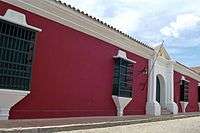
With its earthen constructions unique in the Caribbean, Coro is the surviving example of the rich fusion of indigenous traditions with the Spanish Mudéjar architectural techniques and irregular shape of German Welser architecture. It is one of the first colonial cities, was founded in 1527, and its colonial architecture prevails until today. Over 600 buildings have been appointed in Coro as heritage.
The historic centre remains characteristics typical of a city of 18th and 19th centuries, with cobbled stone streets and colonial buildings. This is an important colonial city resort and the largest complex of colonial temples in Venezuela. It contains a variety of museums with a broad representation of Catholic iconography or national historical value, so it is called "la ciudad museo". For these reasons it is declared, along with its nearby port of La Vela de Coro, a World Heritage Site on December 9 of 1993 by Unesco in meeting held in the Colombian city of Cartagena de Indias.
Since 2005 Coro has been officially listed as an "endangered" World Heritage Site (see List of World Heritage in Danger). Climate change in Venezuela, in particular heavy rains, have caused significant damage to its rich architecture. Coro's traditional buildings were built with techniques based on the use of earth (adobe, and earth reinforced with a plant structure in a technique called "bahareque"). Many of these buildings are vulnerable to heavy rains, as in its natural state earth is a material of low resistance to moisture.[7]
As well as the damage from rains between November 2004 and February 2005, the built environment has, according to UNESCO, been adversely affected by the construction of inappropriate walls and fences. There has also been concern about the construction of a new monument, beach walkways and a gateway to the city in the port of La Vela de Coro: these could have a considerable impact on the value of the site.[8]
At present the national government is undertaking investments to preserve its rich architecture.
Monuments and tourist attractions
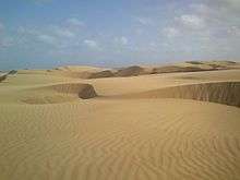
From its historic colonial architecture to its diverse landscapes, Coro provides various forms of tourist attraction. In the extreme northeast of the city are the Médanos de Coro National Park, large dunes that are the only desert in Venezuela. They are located along the road that runs between the colonial area of the city to the port of La Vela de Coro. The colonial town, a World Heritage Site, preserves a typical urban landscape of the 18th and 19th centuries, with its cobbled streets and hundreds of historic and traditional buildings. Some architectures reflects a Mudéjar style, while others reflect the cultural influence of the Netherlands through the colony of Curaçao. In the city there are interesting Catholic and civilians buildings, that were the scene of numerous events of historic significance, since the early Republican period. Probably the architectural influences of Coro are unique.
Among the buildings and places of interest highlights include:
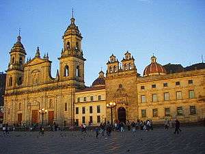
- Cathedral, Minor Basilica of Coro
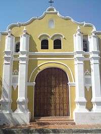
Since the creation of the Diocese of Coro by Bull of July 21 of 1531, it instructs the lift of Cathedral of one of the temples of Coro and in 1567 the Cathedral is sacked by the Corsair Francis Drake. However, the current structure begins to lift in 1583 and is completed by the end of the 17th century, making it the oldest Catholic church in Tierra Firma.
- Casa de las Ventanas de Hierro
Magnificent mansion built in the 17th century by Don José Francisco Garcés de la Colina. This is a house that has a portal that rises to more than eight feet high, and so named because of the large windows protected by a wrought iron structure that was imported from Andalusia.
- Iglesia y Convento de San Francisco
This religious complex consists in a church with three naves and an annex building that was a Franciscan monastery, which now houses the Diocesan Museum "Lucas Guillermo Castillo ". It begins to build in the 16th century and was destroyed by pirates in 1620. Its neo-Gothic tower is of more recent construction stands over 50 meters, which makes it the highest of all assets.
- Iglesia de San Clemente
It has its origins in a church commanded to be built by the founder of the city Juan de Ampíes in the 16th century. It is a cruciform building where each end pointing towards a central point. It is one of the few examples of colonial architecture in the form of a cross in Venezuela.
- Casa del Tesoro
Mansion built in 1770 by the Talavera family, and on this was born Bishop Mariano de Talavera, which famous corian that supported the cause of independence. The origin of its name is from the legend that in its land would be buried a treasure that has not yet been located.
- Balcón de los Arcaya
Great two-story building and topped with a wooden balcony on the second floor. It was built in the 18th century as residence to the Colina Peredo family and takes its name from the family that occupied it since the mid-19th century and which was donated to the nation. It houses thePeople Earthenware Museum.
- Balcón de Bolívar
Also known as Balcón de los Senior. It served as military headquarters of the patriot forces during the War of Independence. It is said that the Liberator Simón Bolívar stayed there on December 23 of 1826 and from the balcony greeted the patriots who gathered outside to greet him. It houses theCoro Art Museum.
- Cruz de San Clemente
It is said that St. Clement's Cross marks the spot where the first mass officiate at South America. It is sheltered by a pavilion erected ordered the Marshal Juan Crisóstomo Falcón during his presidential tenure.
- Jewish cemetery of Coro
It is the oldest Jewish cemetery in South America.[9] Its origin goes back to the 19th century when the Sephardic Jewish colony of the Dutch island of Curaçao began migrating to the city in 1824. This cemetery is beginning to build in 1832 by Joseph Curiel, who buy land in the vicinity of the town to bury his baby daughter Hana. On this are wonderful mausoleums that reflect the spirit of ancient times.
- Iglesia del Carrizal
In this sanctuary is the image of the Virgin of Guadalupe of Carrizal, which according to legend, was rescued in 1723, by Native Americans of the region, of the corian beaches when a vessel sank near the coast of the people. The Natives were shocked to see the perfection of its forms.
- Casa del Sol
It is one of Venezuela's oldest houses, its construction dates from the 17th century. Its name comes from the sun located above its door, symbolizing God.
- Iglesia San Nicolás de Bari
Which would be located outside the city for a long period. It is located west of the historic centre and was built in 1741, for a lady of the Spanish elite, which, according to a promise, she vowed to build a temple on behalf of Saint Nicholas of Bari.
- Arco de la Federación
It is the monument to Marshal Juan Crisóstomo Falcón, a Corian leader during the Federal War and was also President of the Republic from 1863 to 1868.
- Church of San Gabriel
- Museum Alberto Henríquez
- House Gumersindo Torres
- Plaza Manaure
- Garden Dr. Leon Croizat xerophytic
Surrounding area
Traveling one hour north, the tourist will find world-famous beaches for windsurfing in the Paraguaná Peninsula. One hour south, "La Sierra de Coro" presents small towns with a more temperate climate and views of the city. On clear days, visitors will be able to see the médanos (dunes) and behind them the Paraguana Peninsula with its Cerro Santa Ana. Driving west, tourists can also visit Urumaco, an important fossil site. The Sierra de San Luis National Park is 30 km to the south, with a number of attractions including birdwatching and nature observation; Cerro Galicia, the highest hill in the district; the Hueque resurgence cave and associated waterfalls; the Acarite river cave; and the 305 m deep Haitón del Guarataro, the deepest limestone cave in Venezuela.[10][11]
Economy
The economy in Coro is highly dependent on state government expenditure. Retail commercial activity, civil construction and professional services are the principal activities of the city economy.
See also
References
- ↑ UNESCO official website.
- ↑ karen Larkins, Smithsonian Magazine, March 2009, Endangered Site: Port City of Coro, Venezuela
- 1 2 "Coro Climate Normals 1961–1990". National Oceanic and Atmospheric Administration. Retrieved 12 August 2015.
- ↑ "Estadísticos Básicos Temperaturas y Humedades Relativas Máximas y Mínimas Medias" (PDF). INAMEH (in Spanish). Archived from the original (pdf) on 15 June 2013. Retrieved 28 October 2012.
- ↑ "Estadísticos Básicos Temperaturas y Humedades Relativas Medias" (PDF). INAMEH (in Spanish). Archived from the original (pdf) on 15 June 2013. Retrieved 28 October 2012.
- ↑ "Estadísticos Básicos Lluvia" (pdf). INAMEH (in Spanish). Retrieved 28 October 2012.
- ↑ World Heritage Earthen Architecture Programme
- ↑ Coro and its Port, UNESCO
- ↑ remodeled the Jewish cemetery in Coro. Weekly "New World Jewish." Caracas, September 2009
- ↑ Kohn, Beth (2007). Lonely Planet Venezuela. Lonely Planet. p. 154. Retrieved 28 December 2013.
- ↑ "Curimagua". Retrieved 29 December 2013.
External links
| Wikimedia Commons has media related to Coro. |
Coordinates: 11°25′N 69°40′W / 11.417°N 69.667°W
Capital, state | ||||||
Bold indicates national capital. | ||||||
| Bigger Historic Centres |
|  |
|---|---|---|
| Spanish Missions concentrations |
| |
| Cathedrals | ||
| Churches and monateries | ||
| Fortresses | ||
| Bridges and roads | ||
| Other buildings types | ||
| Architecture types | ||
| Modern Revival Style | ||
Category | ||