Marine Corps Air Facility Corvallis
| Marine Corps Air Facility Corvallis | |||||||||||||||
|---|---|---|---|---|---|---|---|---|---|---|---|---|---|---|---|
|
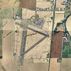
USGS 2006 orthophoto | |||||||||||||||
| IATA: none – ICAO: none | |||||||||||||||
| Summary | |||||||||||||||
| Airport type | Military | ||||||||||||||
| Owner | United States Marine Corps | ||||||||||||||
| Serves | Corvallis, Oregon | ||||||||||||||
| Elevation AMSL | 250 ft / 76 m | ||||||||||||||
| Coordinates | 44°29′50″N 123°17′22″W / 44.49722°N 123.28944°WCoordinates: 44°29′50″N 123°17′22″W / 44.49722°N 123.28944°W | ||||||||||||||
| Map | |||||||||||||||
 MCAF Corvallis Location of airport in Oregon | |||||||||||||||
| Runways | |||||||||||||||
| |||||||||||||||
Marine Corps Air Facility Corvallis is a former United States Marine Corps facility located four nautical miles (5 mi, 7 km) southwest of the central business district of Corvallis, a city in Benton County, Oregon, United States.[1]
History
Original hangar & water tower
The site was built during World War II by the United States Army Air Forces for bomber training. The original hangar is still being used today. After its closure, it was turned over to the city and reopened as Corvallis Municipal Airport.
See also
References
- 1 2 FAA Airport Master Record for CVO (Form 5010 PDF). Federal Aviation Administration. Effective May 31, 2012.
External links
This article is issued from Wikipedia - version of the 12/4/2016. The text is available under the Creative Commons Attribution/Share Alike but additional terms may apply for the media files.

