Corvallis, Oregon
| Corvallis | ||
|---|---|---|
| City | ||
| Corvallis, Oregon | ||
|
| ||
| ||
| Motto: Enhancing Community Livability | ||
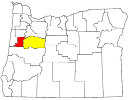
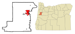 Location of Corvallis within Benton County (left) and Benton County within Oregon (right). | ||
 Corvallis Location in the United States | ||
| Coordinates: 44°34′N 123°17′W / 44.567°N 123.283°WCoordinates: 44°34′N 123°17′W / 44.567°N 123.283°W | ||
| Country | United States | |
| State |
| |
| County | Benton | |
| Founded / Incorporated | 1845 / 1857 | |
| Government | ||
| • Mayor | Biff Traber (D)[1] | |
| Area[2] | ||
| • City | 14.30 sq mi (37.04 km2) | |
| • Land | 14.13 sq mi (36.60 km2) | |
| • Water | 0.17 sq mi (0.44 km2) | |
| Elevation | 235 ft (72 m) | |
| Population (2010)[3] | ||
| • City | 54,462 | |
| • Estimate (2013)[4] | 55,298 | |
| • Density | 3,854.4/sq mi (1,488.2/km2) | |
| • Urban | 62,433 (US: 436th) | |
| • Metro | 86,591 (US: 367th) | |
| Time zone | PST (UTC-8) | |
| • Summer (DST) | PDT (UTC-7) | |
| ZIP codes | 97330-97331, 97333, 97339 | |
| Area code(s) | 541, 458 | |
| FIPS code | 41-15800[3] | |
| GNIS feature ID | 1140162[5] | |
| Website | City of Corvallis | |


Corvallis /kɔːrˈvælᵻs/ is a city in central western Oregon, United States. It is the county seat of Benton County[6] and the principal city of the Corvallis, Oregon Metropolitan Statistical Area, which encompasses all of Benton County. As of the 2010 United States Census, the population was 54,462.[7] Its population was estimated by the Portland Research Center to be 55,298 in 2013.[4] Corvallis is the location of Oregon State University, a large Hewlett-Packard research campus, and Good Samaritan Regional Medical Center.
At a longitude of 123° 17' west, the city is the westernmost city in the contiguous 48 states with a population larger than 50,000.
History
Establishment
In October 1845, Joseph C. Avery arrived in Oregon from the east.[8] Avery took out a land claim at the mouth of Marys River where it flows into the Willamette River and in June 1846 took up residence there in a log cabin hastily constructed to hold what seemed a potentially lucrative claim.[8] Avery's primitive 1846 dwelling was the first home within the boundaries of today's Corvallis and his land claim included the southern section of the contemporary city.[9]
Avery was quickly joined by other settlers along the banks of the Willamette River, including a 640-acre claim directly to his north taken in September 1846 by William F. Dixon.[9] The discovery of gold in California in 1848 temporarily stalled development of a township, with Avery leaving his Oregon claim to try his hand at mining in the fall of that year.[9] His stay would prove to be brief and in January 1849 Avery returned to Oregon with a small stock of provisions with a view to opening a store.[9]
During the year 1849, Avery opened his store at the site, platted the land, and surveyed a town site on his land claim, naming the community Marysville.[10] It is possible that the city was named after early settler Mary Lloyd, but now the name is thought to be derived from French fur trappers' naming of Marys Peak after the Virgin Mary.[11]
In the summer of 1851 Joseph Avery and William Dixon each granted back-to-back 40 acre land parcels from their land holdings for the establishment of a county seat.[12] Avery's holding lay to the south and Dixon's to the north, with the Benton Country Courthouse marking the approximate line of demarcation between these two land parcels.[12]
Name change
In December 1853 the 5th Oregon Territorial Legislature met in Salem, where a petition was presented seeking to change the name of that city to either "Thurston" or "Valena."[13] At the same time, another petition was presented seeking to change the name of Salem to "Corvallis," from the Latin meaning "heart of the valley," while a third resolution was presented to the upper house seeking the change the name of Marysville to Corvallis.[13]
A heated debate followed, with the name ultimately awarded to Marysville in an act passed on December 20, 1853.[13] By way of rationale, it was successfully argued that the name "Marysville" duplicated the moniker of a town in California located on the same stagecoach route and that a name change was thus necessary to avoid confusion.[14]
Incorporation
A faction within the deeply divided legislature sought to make Corvallis the capital of the Oregon Territory, and in December 1855 the 6th Territorial Legislature initially convened there before returning to Salem later that month — the town which would eventually be selected as the permanent seat of state government.[10]
Corvallis was incorporated as a city on January 29, 1857.[15]
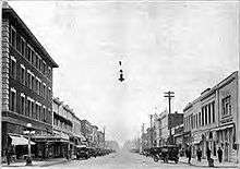
19th Century growth
Nineteenth-century Corvallis saw a three-year boom beginning in 1889, which began with the establishment of a privately owned electrical plant by L.L. Hurd.[16] A flurry of publicity and public and private investment followed, including construction of a grand county courthouse, planning and first construction of a new street railway, construction of a new flour mill along the river between Monroe and Jackson Avenues, and construction of the Hotel Corvallis, today known as the Julian Hotel.[16]
In addition a carriage factory was launched in the city and the town's streets were improved, while the size of the city was twice enlarged through annexation.[16] Bonds were issued for a city-owned water works, a sewer system, and for public ownership of the electric plant.[16] A publicity campaign was launched to attempt to expand the tax base through new construction for new arrivals.[16] This effort proved mostly unsuccessful, however, and in 1892 normalcy returned, with the city saddled with about $150,000 in bonded debt.[16]
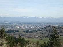
Geography
Corvallis is at an elevation of 235 feet (72 m) above sea level.[17] Situated midway in the Willamette Valley, Corvallis is about 46 miles (74 km) east of Newport and the Oregon Coast, 85 miles (137 km) south of Portland, 30 miles (48 km) south of the state capital, Salem, 10 miles (16 km) southwest of Albany, about 10 miles (16 km) west of Interstate 5 at its closest point, and 48 miles (77 km) north of Eugene/Springfield. Oregon Route 99W, a secondary north–south route, also runs through Corvallis. U.S. Route 20 (which leads to Newport) and Oregon Route 34 (which leads to Waldport about 56 miles (90 km) to the west) both secondary East-West routes run through Corvallis from the Oregon Coast. Corvallis is at river mile 131–32 of the Willamette River.[18]
According to the United States Census Bureau, the city has a total area of 14.30 square miles (37.04 km2), of which 14.13 square miles (36.60 km2) is land and 0.17 square miles (0.44 km2) is water.[2]
Climate
Like the rest of the Willamette Valley, Corvallis falls within the dry-summer subtropical climate zone, also referred to as cool-summer Mediterranean (Köppen Csb). Temperatures are mild year round, with warm, dry sunny summers and mild, wet winters with persistent overcast skies. Spring and fall are also moist seasons with varied cloudiness, and light rain falling for extended periods.
Winter snow is rare, but occasionally does fall, and amounts can range between a dusting and a few inches that does not persist on the ground for more than a day. The northwest hills will often experience more snow. During the mid-winter months after extended periods of rain, thick persistent fogs can form, sometimes lasting the entire day. This can severely reduce visibility to as low as 20 feet (6.1 m). The fog will often persist until a new storm system enters the area. This fog could be seen as a type of tule fog.
Rainfall total within the town itself is surprisingly variable. This is due to Corvallis lying right on the eastern edge of the Oregon Coast Range, with a small portion of the town inside of the range. Rainfall amounts can range from an average of 66.40 inches (168.7 cm) per year [19] in the far northwest hills, compared to 43.66 inches (110.9 cm) per year at Oregon State University which is located in the center of Corvallis.
Because of its close proximity to the coastal range, Corvallis can experience slightly cooler temperatures, particularly in the hills, than the rest of the Willamette Valley. The average annual low temperature is 4 degrees less than that of Portland just 85 miles (137 km) to the north. Despite this, temperatures dropping far below freezing are still a rare event.
| Climate data for Corvallis, Oregon (Oregon State University) | |||||||||||||
|---|---|---|---|---|---|---|---|---|---|---|---|---|---|
| Month | Jan | Feb | Mar | Apr | May | Jun | Jul | Aug | Sep | Oct | Nov | Dec | Year |
| Record high °F (°C) | 66 (19) |
68 (20) |
76 (24) |
85 (29) |
96 (36) |
102 (39) |
105 (41) |
108 (42) |
103 (39) |
92 (33) |
72 (22) |
66 (19) |
108 (42) |
| Average high °F (°C) | 47.0 (8.3) |
51.0 (10.6) |
56.1 (13.4) |
60.7 (15.9) |
67.1 (19.5) |
73.4 (23) |
81.2 (27.3) |
82.4 (28) |
77.1 (25.1) |
65.4 (18.6) |
52.9 (11.6) |
46.4 (8) |
63.39 (17.44) |
| Average low °F (°C) | 33.6 (0.9) |
35.4 (1.9) |
37.6 (3.1) |
39.9 (4.4) |
44.0 (6.7) |
48.5 (9.2) |
51.8 (11) |
51.5 (10.8) |
48.2 (9) |
41.8 (5.4) |
38.0 (3.3) |
33.8 (1) |
42.01 (5.56) |
| Record low °F (°C) | −1 (−18) |
1 (−17) |
12 (−11) |
24 (−4) |
28 (−2) |
33 (1) |
38 (3) |
37 (3) |
27 (−3) |
22 (−6) |
14 (−10) |
−7 (−22) |
−7 (−22) |
| Average precipitation inches (mm) | 6.46 (164.1) |
5.71 (145) |
4.59 (116.6) |
2.98 (75.7) |
2.30 (58.4) |
1.46 (37.1) |
.57 (14.5) |
.73 (18.5) |
1.47 (37.3) |
3.02 (76.7) |
6.94 (176.3) |
7.43 (188.7) |
43.66 (1,109) |
| Average snowfall inches (cm) | 1.2 (3) |
2.2 (5.6) |
.1 (0.3) |
0 (0) |
0 (0) |
0 (0) |
0 (0) |
0 (0) |
0 (0) |
0 (0) |
.2 (0.5) |
1.4 (3.6) |
5.1 (13) |
| Average precipitation days (≥ 0.01 in) | 19.7 | 18.0 | 18.8 | 16.3 | 12.7 | 7.8 | 3.6 | 3.9 | 7.1 | 12.4 | 20.1 | 20.8 | 161.2 |
| Average snowy days (≥ 0.1 in) | .9 | 1.1 | .2 | 0 | 0 | 0 | 0 | 0 | 0 | 0 | .1 | .8 | 3.1 |
| Source #1: NOAA (normals, 1971–2000),[20] | |||||||||||||
| Source #2: Weather.com (extremes) [21] | |||||||||||||
Demographics
| Historical population | |||
|---|---|---|---|
| Census | Pop. | %± | |
| 1880 | 1,128 | — | |
| 1890 | 1,527 | 35.4% | |
| 1900 | 1,819 | 19.1% | |
| 1910 | 4,552 | 150.2% | |
| 1920 | 5,752 | 26.4% | |
| 1930 | 7,585 | 31.9% | |
| 1940 | 8,392 | 10.6% | |
| 1950 | 16,207 | 93.1% | |
| 1960 | 20,669 | 27.5% | |
| 1970 | 35,056 | 69.6% | |
| 1980 | 40,960 | 16.8% | |
| 1990 | 44,757 | 9.3% | |
| 2000 | 49,322 | 10.2% | |
| 2010 | 54,462 | 10.4% | |
| Est. 2015 | 55,780 | [22] | 2.4% |
| Sources:[4][23][24][25] | |||
Corvallis is the largest principal city of the Albany-Corvallis-Lebanon CSA, a Combined Statistical Area that includes the Corvallis metropolitan area (Benton County) and the Albany-Lebanon micropolitan area (Linn County),[26][27][28] which had a combined population of 202,251 at the 2010 U.S. Census.[3]
As of the 2000 U.S. Census the median income for a household in the city was $35,437, and the median income for a family was $53,208. Males had a median income of $40,770 versus $29,390 for females. The per capita income for the city was $19,317. About 9.7% of families and 20.6% of the population were below the poverty line, including 15.2% of those under age 18 and 6.0% of those age 65 or over.[3]
2010 census
As of the 2010 U.S. Census, there were 54,462 people, 22,283 households, and 10,240 families residing in the city. The population density was 4004.5 people per square mile (1,547.2/km²). There were 23,423 housing units at an average density of 1,722.3 per square mile (665.4/km²). The racial makeup of the city was 83.8% White, 7.3% Asian, 1.1% Black or African American, 0.69% Native American, 0.33% Hawaiian or Pacific Islander, 2.8% from other races, and 4.0% from two or more races. 7.4% of the population were Hispanic or Latino of any race.[3]
There were 22,283 households of which 20.7% had children under the age of 18 living with them, 35.3% were married couples living together, 7.0% had a female householder with no husband present, and 54.0% were non-families. 33.2% of all households were made up of individuals and 8.9% had someone living alone who was 65 years of age or older. The average household size was 2.22 and the average family size was 2.82.[3]
In the city the population was spread out with 14.9% under the age of 18, 32.4% from 18 to 24, 22.9% from 25 to 44, 19.3% from 45 to 64, and 10.5% who were 65 years of age or older. The median age was 26.4 years. For every 100 males there were 98.7 females.[3]
Religion
In 1903, Franz Edmund Creffield, commonly known as Edmund Creffield (c. 1870–1906), a German-American religious leader who called himself Joshua, founded a movement in Corvallis which became known locally as the "Holy Rollers".
Corvallis lies in the middle of the Unchurched Belt. A 2003 study, released once every 10 years, listed Benton County (of which Corvallis makes up the majority of the population) as the least religious county per capita in the United States. Only 1 in 4 people indicated that they were affiliated with one of the 149 religious groups the study identified. The study indicated that some of the disparity, however, may be attributed to the popularity of less common religions (ones not included as an option in the study) in the Pacific Northwest.[29]
Economy
The campus of Oregon State University, which is the major local employer, is located near the edge of the main downtown area. Other major employers include Samaritan Health Services,[30] CH2M HILL,[31] SIGA Technologies,[32] Evanite Fiber,[33] ONAMI,[34] and Hewlett-Packard, whose printer cartridge manufacturing and prototyping facility is located in the northeast area of town. Because of this relative concentration of employment and the need for diversity, the city launched a website to attract creative industry to the region by branding it with the slogan "Yes Corvallis".[35] The National Clonal Germplasm Repository at Corvallis is a gene bank of the United States Department of Agriculture Agricultural Research Service. The gene bank preserves temperate fruit, nut, and agronomic crops from around the world.[36]
Corvallis, Oregon was ranked #48[37] on the 100 best places in the USA to live and launch a business by Fortune Small Business 2008.[38] This places Corvallis as the second best place in Oregon to launch a business, after Portland (#6). Bend (#87) and Eugene (#96) were other Oregon localities ranked in the top 100.
Politics
Helen Berg served as mayor of Corvallis for three terms from 1994 until 2006. She holds the distinction of being the first female mayor of Corvallis, as well as the longest-serving mayor of the city to date.[39] Two members of the Corvallis city council are members of the Green Party.[40] The current mayor is Biff Traber.
Arts and culture
Annual cultural events
- Da Vinci Days festival and the annual kinetic sculpture race.[41]
- Corvallis Fall Festival Annual Arts Party in Central Park. Founded in 1972, with the 39th occurrence in 2011.[42]
Museums and other points of interest
- Benton County Courthouse[43]
- Hesthavn Nature Center of the Audubon Society of Corvallis[44]
- McDonald State Forest[45]
- Peavy Arboretum
- Corvallis-Benton County Public Library[46]
- Corvallis Farmers' Market[47]
Art galleries
Sports
As the home of Oregon State University, Corvallis is the home for 17 NCAA Division I OSU teams (7 men's, 10 women's) in the Pac-12 Conference. Corvallis is also the home of the Corvallis Knights baseball team, who play in summer at OSU's Goss Stadium. The Knights play in the West Coast League, an independent summer baseball league with teams from Washington, Oregon, and British Columbia.
Parks and recreation
Corvallis is recognized as a Tree City USA. The city has at least 47 public parks within and adjacent to the city limits.[51]
Education
Education has had a place in Corvallis since the earliest days of the town, with the first school building constructed in 1848 and put to use in 1850.[9]
During the first decade of the 21st century, local boosters claimed that Corvallis had the highest education rate per capita of any city in the state of Oregon.[52]
Public schools in the city are administered by the Corvallis School District. Corvallis is also the home of Oregon State University and the Benton Center campus of Linn-Benton Community College.
Media
- Corvallis Gazette-Times, daily newspaper
- The Corvallis Advocate, a free alternative newsweekly focusing on science and art.[53]
- The Daily Barometer, the Oregon State University campus newspaper
Corvallis is part of the Eugene, Oregon, radio and television market.
Transportation
Bus
Long-distance bus service is provided by Greyhound. It stops at the Greyhound station in downtown Corvallis (station ID: CVI.)
Local bus service is provided by Corvallis Transit System (CTS). In January 2011, the Corvallis City Council approved an additional fee on monthly water utility bills allowing all CTS bus service to become fareless.[54][55] The system runs a total of eight daytime routes Monday through Saturday, covering most of the city and converging at a Downtown Transit Center. Additional commuter routes also run in the early morning and late afternoon on weekdays, and mid-morning and mid-afternoon on Saturdays. When Oregon State University is in session CTS also runs the "Beaver Bus," a set of late-night routes running Thursday through Saturday.
Two other short-distance inter-city buses, the Linn-Benton Loop (to Albany) and the Philomath Connection, also stop at the Downtown Transit Center.
From 2010 to 2011, CTS has seen a 37.87% increase in ridership, partially as a result of going fareless and "the rising cost of fuel for individual vehicles and the desire for residents to choose more sustainable options for commuting to work, school and other activities"[56] According to Tim Bates the Corvallis Transit System and Philomath Connection, had 3,621,387 passenger miles traveled and 85,647 gallons of fuel consumed in Fiscal Year 2011, a period that covers July 1, 2010 - June 30, 2011. This means that riders in Fiscal Year 2011 got 42.28 passenger miles per gallon.
Bicycle
The League of American Bicyclists gave Corvallis a gold rating as a Bicycle-Friendly Community in 2011.[57] Also, according to the United States Census Bureau's 2008–12 American Community Survey, 11.2 percent of workers in Corvallis bicycle to work. The city of Corvallis is ranked third highest among 'small' U.S. cities (with populations under 200,000) for bicycle commuters, behind Key West, Florida (17.4) and Davis, California (18.6).[58]
Air
Corvallis Municipal Airport serves private and corporate aircraft. The closest commercial air service is available at Eugene Airport, 35 miles (56 km), or Portland International Airport, 95 miles (153 km).
Bridges
Utilities
Water
The city's water system contains two water treatment plants, nine processed water reservoirs, one raw water reservoir, and some 210 miles (340 km) of pipe. The system can process up to about 19 million US gallons (72,000 m3) of water per day.[59]
The Rock Creek treatment plant processes water from sources in the 10,000-acre (40 km2) Rock Creek Municipal Watershed near Marys Peak. The three sources are surface streams which are all tributaries of the Marys River. Rock Creek has a processing capacity of 7 million US gallons (26,000 m3) of water per day (gpd), though operational characteristics of the 9-mile (14 km), 20-inch (51 cm) pipeline to the city limits capacity to half that.[60] The Rock Creek Plant output remains steady year round at about 3 million US gallons (11,000 m3).[59]
The H.D. Taylor treatment plant obtains water from the Willamette River, and has been expanded at least four times since it was first constructed in 1949. Its output varies seasonally according to demand, producing from 2 to 16 million US gallons (7,600 to 60,600 m3) per day,[59] though it has a capacity of 21 million US gallons (79,000 m3) per day.[60]
The total reservoir capacity is 21 million US gallons (79,000 m3),[61] though measures to voluntarily reduce water usage begin when reservoir levels fall below 90 percent of capacity, and become mandatory at 80 percent or below.[62] As part of its ongoing water conservation program, the water department jointly publishes a guide to water-efficient garden plants.[63]
Green power
According to the federal Environmental Protection Agency report on its “green power communities,” Corvallis is among the top cities in the nation in terms of buying electricity produced from renewable resources. Corvallis purchases more than 126 million kilowatt-hours of green power annually, which amounts to 21 percent of the city’s total purchased electricity.[64][65]
Fire department
As of 2012 the Corvallis Fire Department is headed by Chief Roy Emery and currently has six fire stations.[66]
Notable people
- This list excludes persons whose only connection to Corvallis is attendance or employment at Oregon State University.
- Debra Arlyn (born 1986), singer-songwriter
- Joseph C. Avery (1817–1876), Marysville town founder and politician
- Brad Badger (born 1975), NFL player
- Brad Bird (born 1957), animator, writer, and director (The Incredibles, The Iron Giant, Ratatouille)
- Chris Botti (born 1962), jazz trumpet musician
- Kevin Boss (born 1984), NFL player
- Meredith Brooks (born 1958), singer, songwriter, and producer[67]
- James Cassidy, member of the band Information Society
- Robert Cheeke, bodybuilder and vegan activist
- Randy Couture, mixed martial artist and UFC Hall of Fame member
- Edmund Creffield, founder of the 'Bride of Christ Church' also known as the 'Holy Rollers'
- Christopher L. Eisgruber, Rhodes Scholar and 20th president of Princeton University
- Dick Fosbury (1947–), 1968 Olympics gold medalist and innovator of the modern back-first method of high jumping
- Bob Gilder (1950–), American professional golfer and currently a member of the Champions Tour
- Gordon Gilkey (1912–2000), artist and educator
- Kevin Gregg (1978–), MLB player
- Les Gutches (1973–), Olympic wrestler, world champion
- Nick Hundley (1983–), MLB Player
- Eyvind Kang, violinist and composer
- Paul Kocher, cryptographer
- Jon Krakauer, author (Into Thin Air, Under the Banner of Heaven, etc.) and mountaineer
- Wayne Krantz, guitarist
- Jane Lubchenco, marine biologist, named in 2009 to head the National Oceanic and Atmospheric Administration
- Bernard Malamud, author, the setting for whose book A New Life was based on Corvallis
- Ben Masters (1947–), actor, notable for his role in the soap opera Passions, and various stage and film works.[67]
- Ralph Miller (1919–2001), basketball coach, enshrined in the Naismith Memorial Basketball Hall of Fame
- Barbara Minty, (also known as Barbara Minty McQueen) Vogue model and wife of the late actor Steve McQueen[67]
- Linus Pauling (1901–1994), 1954 Nobel Prize in Chemistry and 1962 Nobel Peace Prize recipient (Graduated from Oregon Agricultural College, now Oregon State University)
- Mario Pastega (1916–2012), businessman and philanthropist
- Jason Reed, actor, musician
- Harold Reynolds (1960–), former MLB player and former ESPN broadcaster
- Doug Riesenberg (1965–), former NFL offensive tackle
- Mike Riley (1953–), former NFL head coach (San Diego Chargers), currently the Nebraska Cornhuskers head football coach
- Craig Robinson (1962–), former Oregon State Beavers head basketball coach and brother-in-law of U.S. President Barack Obama
- Jordan Smotherman, NHL prospect for the Atlanta Thrashers
- Jami Tobey, contemporary painter
- Robb Thomas, former NFL player
- Ernest H. Wiegand, professor of horticulture and developer of the modern method of manufacture of the maraschino cherry.
- Carl Wieman, 2001 Nobel Prize in Physics recipient for creation of the Bose-Einstein Condensate
- Dan Williams, former MLB player and current assistant MLB coach with the Cleveland Indians
- Bushrod Washington Wilson (1828–1900), pioneer, railroad executive, and county functionary
- Mike Zandofsky, former NFL player
Sister cities
Corvallis has two sister cities,[68] as designated by Sister Cities International:
References
- ↑ "Biff Traber". Democratic Party of Oregon. Retrieved 2 October 2015.
- 1 2 "US Gazetteer files 2010". United States Census Bureau. Archived from the original on 2012-07-14. Retrieved 2012-12-21.
- 1 2 3 4 5 6 7 "American FactFinder". United States Census Bureau. Retrieved 2012-12-21.
- 1 2 3 "Population Estimates". United States Census Bureau. Retrieved 2014-10-02.
- ↑ "US Board on Geographic Names". United States Geological Survey. 2007-10-25. Retrieved 2008-01-31.
- ↑ "Find a County". National Association of Counties. Archived from the original on 2011-05-31. Retrieved 2011-06-07.
- ↑ "2010 Census Redistricting Data". U.S. Census Bureau American FactFinder. Retrieved 2011-03-09.
- 1 2 David D. Fagan, History of Benton County, Oregon: Including... a Full Political History, ...Incidents of Pioneer Life, and Biographical Sketches of Early and Prominent Citizens... Portland, OR: A.G. Walling, Printer, 1885; pg. 422. Note that a clear typographical error in the original source has Avery's date of arrival as "October 1846" but beginning of his residence in "June 1846."
- 1 2 3 4 5 Fagan, History of Benton County, Oregon, pg. 423.
- 1 2 Howard M. Corning, Dictionary of Oregon History. Portland: Binfords & Mort Publishing, 1956.
- ↑ Corvallis Gazette Times: Archived Articles
- 1 2 Fagan, History of Benton County, Oregon, pg. 424.
- 1 2 3 Charles H. Carey, A General History of Oregon Prior to 1861: In Two Volumes: Volume II: To the Civil War. Portland, OR: Metropolitan Press, 1936; pg. 662.
- ↑ Fagan, History of Benton County, Oregon, pg. 425.
- ↑ corvallis150.org
- 1 2 3 4 5 6 Bruce Martin, "Bushrod Washington Wilson," Oregon Historical Quarterly, vol. 39, no. 3 (Sept. 1938), pp. 283-284.
- ↑ "US Gazetteer files: 2010, 2000, and 1990". United States Census Bureau. 2011-02-12. Retrieved 2011-04-23.
- ↑ Willamette River Recreation Guide. 2007. Extension Service, Oregon State University. Available online from the state government of Oregon.
- ↑ Oregon USA Weather History and Climate Data
- ↑ "Climatography of the United States No. 20 1971–2000: CORVALLIS STATE UNIV, OR" (PDF). National Oceanic and Atmospheric Administration. Retrieved 2011-12-07.
- ↑ "Monthly Averages for Corvallis, OR (97331)". The Weather Channel. Retrieved 2011-12-07.
- ↑ "Annual Estimates of the Resident Population for Incorporated Places: April 1, 2010 to July 1, 2015". Retrieved July 2, 2016.
- ↑ "American FactFinder". United States Census Bureau. Archived from the original on 2013-09-11. Retrieved 2008-01-31.
- ↑ "Number of Inhabitants: Oregon" (PDF). 18th Census of the United States. U.S. Census Bureau. Retrieved 22 November 2013.
- ↑ "Oregon: Population and Housing Unit Counts" (PDF). U.S. Census Bureau. Retrieved 22 November 2013.
- ↑ METROPOLITAN STATISTICAL AREAS AND COMPONENTS Archived May 26, 2007, at the Wayback Machine., Office of Management and Budget, 2007-05-11. Accessed 2008-08-01.
- ↑ MICROPOLITAN STATISTICAL AREAS AND COMPONENTS Archived June 29, 2007, at the Wayback Machine., Office of Management and Budget, 2007-05-11. Accessed 2008-08-01.
- ↑ COMBINED STATISTICAL AREAS AND COMPONENT CORE BASED STATISTICAL AREAS Archived June 29, 2007, at the Wayback Machine., Office of Management and Budget, 2007-05-11. Accessed 2008-08-01.
- ↑ Reeves, Carol (2003-12-21). "Where are the faithful?". Corvallis Gazette-Times. Archived from the original on 2009-08-03. Retrieved 2009-01-27.
- ↑ "Samaritan Health Services". Samhealth.org. Retrieved 2012-08-27.
- ↑ "CH2M HILL: Region Selection". Ch2m.com. Retrieved 2012-08-27.
- ↑ "Smallpox Antiviral and Biodefense Drug Development". SIGA. 2012-04-16. Retrieved 2012-08-27.
- ↑ http://www.evanite.com/
- ↑ "ONAMI | Home". Onami.us. 2012-08-02. Retrieved 2012-08-27.
- ↑ http://yescorvallis.org/
- ↑ "National Clonal Germplasm Repository - Corvallis, Oregon". USAD Agricultural Research Service. 07/02/2010. Retrieved 2010-07-06. Check date values in:
|date=(help) - ↑ "100 Best Places To Live And Launch". CNN. 2008-07-02.
- ↑ "100 Best places to live and launch 2008: Top 100". CNN.
- ↑ Novak, Theresa (2010-08-17). "Helen Berg, Corvallis' first woman mayor, dies at 78". Corvallis Gazette-Times. Retrieved 2010-08-22.
- ↑ "Green officeholders".
- ↑ Da Vinci Days festival website
- ↑ Corvallis fall festival website
- ↑ "index". Courts.oregon.gov. Retrieved 2012-08-27.
- ↑ "Hesthavn Nature Center". Audubon.corvallis.or.us. Retrieved 2012-08-27.
- ↑ "OSU Research Forests: McDonald-Dunn Forest". Oregon State University. Retrieved 2016-04-08.
- ↑ "index". thebestlibrary.net. Retrieved 2013-07-23.
- ↑ "Corvallis-Albany Farmers' Markets". locallygrown.org. Retrieved 2016-04-08.
- ↑ "The Arts Center in Corvallis, Oregon". Retrieved 2016-04-08.
- ↑ "Giustina Gallery, The LaSells Stewart Center". Oregon State University. Retrieved 2016-04-08.
- ↑ "Fairbanks Gallery, Current Exhibit". Oregon State University. Retrieved 2016-04-08.
- ↑ "Corvallis Parks & Recreation" (PDF). City of Corvallis. Retrieved 2009-09-03.
- ↑ "About Corvallis," Corvallis Chamber of Commerce and Visitor's Bureau, www.www.visitcorvallis.com/ URL accessed May 11, 2006.
- ↑ "About Us". Corvallis Advocate. Retrieved July 2014. Check date values in:
|access-date=(help) - ↑ Nancy Raskauskas (2011-02-01). "Corvallis Transit System drops bus fares". Corvallis Gazette-Times. Retrieved 2015-08-02.
- ↑ "Bus Fares / Fareless". Corvallis Transit System. 2015. Retrieved 2015-08-02.
- ↑ pg. 3
- ↑ "Eleven New Bicycle Friendly Communities Designated: City Leaders Invest in Bicycle‐friendly Future". League of American Bicyclists. September 14, 2011. Retrieved March 9, 2012.
- ↑ McKenzie, Brian (May 2014). "Modes Less Traveled - Bicycling and Walking to Work in the United States: 2008–2012" (PDF). American Community Survey Reports.
- 1 2 3 "Water Utility". City of Corvallis Public Works. Retrieved 2009-01-26.
- 1 2 "Water Treatment Facilities". City of Corvallis Public Works. Retrieved 2009-01-26.
- ↑ "Water Distribution". City of Corvallis Public Works. Retrieved 2009-01-26.
- ↑ "Water Supply Emergency Curtailment Plan". City of Corvallis Public Works. Retrieved 2009-01-26.
- ↑ "Water Efficient Plants for the Willamette Valley" (PDF). City of Corvallis Public Works. c. 2004. Retrieved 2009-01-26.
- ↑ Neznanski, Matt (2009-01-31). "Corvallis Tops Green Cities List". Retrieved 2009-02-03.
- ↑ Green Power Partnership (2012-03-26). "Green Power Community Challenge Rankings". United States Environmental Protection Agency. Retrieved 2012-05-04.
- ↑ http://www.ci.corvallis.or.us/downloads/fire/1011%20Annual%20Report.pdf
- 1 2 3 "Corvallis High School Alumni Page". Retrieved 2011-08-20.
- ↑ Corvallis Sister Cities Association
Further reading
- Benton County Citizens' League, Benton County, Oregon, illustrated: Published under Direction of the Benton County Citizens' League. n.c.: n.p., 1904.
- Benton County Historical Society and Museum, A Pictorial History of Benton County. Corvallis, OR: Corvallis Gazette-Times, 2000.
- Tim Chandler, Street Politics and Bobby Packwood: A Participant's Memoir of the Corvallis, Oregon, Anti-Packwood Demonstration of January 27, 1993. Corvallis, OR: 1000 Flowers Publishing, 2003.
- Downtown Corvallis Association, "Downtown Corvallis Association Membership Application (1979)," Corvallis, OR: Downtown Corvallis Association, 1979. —Includes short history of origins and purposes.
- David D. Fagan, History of Benton County, Oregon: Including... a Full Political History, ...Incidents of Pioneer Life, and Biographical Sketches of Early and Prominent Citizens... Portland, OR: A.G. Walling, Printer, 1885.
- Oregon State College, Outline History of Oregon State College. Corvallis, OR: Oregon State College, 1950.
- David A Pinyerd, Bernadette Niederer, and Tony Vandermeer, A History of Corvallis High School. Corvallis, OR: Corvallis School District 509J, 2005.
- Minerva Kiger Reynolds, Corvallis in 1900. Corvallis, OR: Minerva Kiger Reynolds, n.d. [1976].
- M. Boyd Wilcox, Two to Four O'clock at The Beanery : A Journal of Observations, Analyses, Interviews, and Commentary Regarding a First-Rate "Third Place" in Downtown Corvallis, Oregon. Corvallis, OR: n.p., 2012.
External links
| Wikimedia Commons has media related to Corvallis, Oregon. |
 Corvallis, Oregon travel guide from Wikivoyage
- Entry for Corvallis in the Oregon Blue Book
- Corvallis Convention & Visitors Bureau
- Corvallis Wiki: Community Wiki for Corvallis
Municipalities and communities of Benton County, Oregon, United States | ||
|---|---|---|
| Cities | 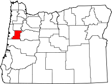 | |
| CDPs | ||
| Other unincorporated communities | ||
| Footnotes | ‡This populated place also has portions in an adjacent county or counties | |