Cotobade
| Concello de Cotobade | ||
|---|---|---|
| municipality | ||
| ||
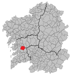 Situation of Cotobade within Galicia | ||
| Coordinates: 42°28′N 8°28′W / 42.467°N 8.467°WCoordinates: 42°28′N 8°28′W / 42.467°N 8.467°W | ||
| Government | ||
| • Alcalde (Mayor) | Manoel Loureiro | |
| Population (2011) | ||
| • Total | 4,432 | |
| (INE) | ||
| Time zone | CET (UTC+1) | |
| • Summer (DST) | CET (UTC+2) | |
| Website |
www | |

Cotobade is a municipality in Galicia, Spain in the province of Pontevedra. It borders the municipalities of Campo Lameiro, Cerdedo, Forcarei, A Lama, Ponte Caldelas and Pontevedra. In 2011 its population was 4,432 people, according to the INE.
Cotobad is divided internally into several administrative divisions that match the name of parishes. Among the most prominent geographical features are the Lérez river, which flows through the lowlands of the municipality and its tributary and the river Almofrei. Of the mountains, the most prominent is Mount Seixo, one of the main mountains in Galicia.
The name of Cotobad apparently comes from "couto do abade." The whole region belonged to the old jurisdiction that exercised the Ranking of the Convent of Benedictine Tenorio.
Geographic data
The municipality is located west of Galicia and east of the province Pontevedra, to which it administratively belongs.