Counties of Victoria
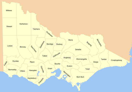
The counties of Victoria are names of the divisions used in Victoria, Australia, for land administration purposes. Victoria is divided into 37 counties, which were gazetted in stages between 1849 and 1871 as Victoria was progressively opened up to British settlement. Unlike counties in the United States and the United Kingdom, Victoria's counties have no administrative or political function. They exist purely as cadastral units: used for the purposes of identifying the location of any piece of land. The counties are further divided into 2914 parishes and townships.
The county names have also been traditionally used as names for Victorian electoral districts, although the boundaries of these districts seldom coincided with county boundaries. The boundaries for Victorian forecast districts are also based on county boundaries.[1]
History

Following the unauthorised settlement of settlers from Tasmania (then called Van Diemen's Land) in the future Melbourne in 1835, in September 1836, Governor Bourke established the Port Phillip District of New South Wales. He also commissioned Robert Hoddle to make the first plan for the town. The plan was completed on 25 March 1837, and came to be known as the Hoddle Grid.[2] The surveys were intended to prepare for land sales. The boundaries of the Port Phillip District were not settled until 1 July 1843, when a proclamation formalised the border as running from Cape Howe, to the nearest source of the Murray River, and then along the course of the Murray to the border with South Australia.[3]
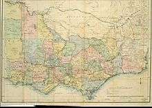
Before the division of the Port Phillip District into counties, Victoria was divided into land districts, as shown on an 1864 map.[4] The land districts were used as the names for parts of the state where counties had yet to be proclaimed. The land districts included:
- Bourke Land District (Melbourne area, including the County of Bourke)
- Geelong (or Grant) Land District
- Gipps Land District (name for the area today is still Gippsland)
- Loddon Land District
- Murray Land District
- Normanby Land District [5]
- Western Land District
- Wimmera Land District (the southern part still called the Wimmera today)
Counties were proclaimed or changed in 1849, 1853, 1869, 1870 and 1871. The proclamation of counties of 1849 was made while Port Phillip District was part of New South Wales, while the others were made after the separation from NSW in 1851, to create the colony of Victoris.
Earlier maps of Gippsland area in the eastern part of Victoria show proposed counties of Douro (a title of the Duke of Wellington), Bass, Haddington, Bruce, Abinger, Combermere and Howe with approximate boundaries. These counties are shown on several early maps such as an 1845 map[6] and 1848 map.[7] They were presumably changed in the mid-1860s, as they appear on maps up until 1864,[8] but the new counties appear on an 1865 map.[9]
In turn, all parish boundaries were gazetted by 1890.
Naming of the counties
The majority of the counties proclaimed prior to 1871 were named after British politicians. The counties formed from the Gipps Land District, Loddon Land District, Murray Land District and Wimmera Land District proclaimed in 1871 were all given aboriginal names.
List of Victorian counties
The Victorian counties and the year they were proclaimed are:[10]
| Year | County name |
|---|---|
| 1849 | Anglesey |
| 1871 | Benambra |
| 1869 | Bendigo |
| 1871 | Bogong |
| 1871 | Borung |
| 1853 | Bourke |
| 1871 | Buln Buln |
| 1871 | Croajingolong |
| 1849 | Dalhousie |
| 1871 | Dargo |
| 1871 | Delatite |
| 1849 | Dundas |
| 1849 | Evelyn |
| 1849 | Follett |
| 1870 | Gladstone |
| 1853 | Grant |
| 1849 | Grenville |
| 1871 | Gunbower |
| 1849 | Hampden |
| 1849 | Heytesbury |
| 1871 | Kara Kara |
| 1871 | Karkarooc |
| 1871 | Lowan |
| 1871 | Millewa |
| 1871 | Moira |
| 1849 | Mornington |
| 1853 | Normanby |
| 1849 | Polwarth |
| 1849 | Ripon |
| 1871 | Rodney |
| 1849 | Talbot |
| 1871 | Tambo |
| 1871 | Tanjil |
| 1871 | Tatchera |
| 1849 | Villiers |
| 1871 | Weeah |
| 1871 | Wonnangatta |
See also
- List of localities (Victoria)
- Local government areas of Victoria
- List of places in Victoria (Australia) named from pastoral runs
- Regions of Victoria
References
- ↑ "Victorian Forecast Areas Map". Bureau of Meteorology. Commonwealth of Australia.
- ↑ "City of Melbourne — Roads — Introduction". City of Melbourne. Retrieved 29 September 2008.
- ↑ "What is the northern boundary of Victoria?". The Age. 1906-04-21. Retrieved 2009-04-26.
- ↑ Stephens, W. B. (1864). "Stephens' new map of Victoria". National Library of Australia. Melbourne: W. B. Stephens.
- ↑ Skene, Alexander James (1945). "Map of the district of Geelong". Geelong, Victoria: Jas. Harrison, Advertiser Office.
- ↑ Rapkin, John (1845). "Australia". National Library of Australia. London.
- ↑ "(No 2.) outline map shewing the positions of the proposed New Counties in the Port Phillip district which will be ready for Proclamation before the end of the Year 1848". National Library of Australia. London: J. Arrowsmith. 1948.
- ↑ Bartholomew, John (1864). "Victoria". National Library of Australia. London; Liverpool: George Philip & Son.
- ↑ Victoria. Dept. of Crown Lands and Survey (1865). "Map of Victoria". National Library of Australia. Melbourne: Dept. of Lands & Survey.
- ↑ "List of the Counties in the State of Victoria - 1910". Rootsweb Genealogy. Ancestry.com. 2000. Retrieved 2008-09-20.