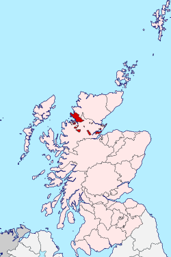
Cromartyshire
Coordinates: 57°36′N 4°00′W / 57.6°N 4.0°W
| Cromartyshire | |
|---|---|
 | |
| Area | |
| • 1881 | 217,321.186 acres (879 km2) |
| History | |
| • Abolished | 1890 |
| • Succeeded by | Ross and Cromarty |
| Status | County |
| • HQ | Cromarty |
Cromartyshire is a historic county in the Highlands of Scotland, comprising the medieval "old shire" around the county town of Cromarty and 22 exclaves transferred from Ross-shire in the late 17th century. The largest part, six times the size of the old shire, is Coigach, northwest from Ullapool. In 1890, Cromartyshire was merged with Ross-shire into the administrative county of Ross and Cromarty. In 1975, the resulting county was combined with Caithness, Inverness-shire, Nairnshire, Sutherland, and parts of Argyllshire and Morayshire to form the Highland council area.
History
The medieval sheriffdom of Cromarty encompassed a single tract on the north of the Black Isle peninsula. The sheriffdom was hereditary in Clan Urquhart.[1] It comprised the parish of Cromarty; most of the adjacent parish of Kirkmichael, excluding a portion at Balblair where a ferry crossed the Cromarty Firth to Invergordon; and a single farm in Cullicudden parish.[1] Ownership of the moor of Mulbuie was uncertain between Cromartyshire and Ross-shire.[1][2]
Cromartyshire originally bordered Inverness-shire, but in 1504 Ross-shire was formed out of the nearest parts of Inverness-shire,[3] and its boundaries were fixed in 1661.[1][4] In 1662, Kirkmichael and Cullicudden parishes merged to form the parish of Resolis.[5]
The feudal barony of Cromarty, whose appurtenant land was coterminous with the county, was purchased from the Urquharts in 1682 by the Mackenzies of Tarbat.[6] They owned scattered lands in Ross-shire, including the barony of Tarbat on the Moray Firth north of the Black Isle.[6] In 1685 Sir George Mackenzie, recently made Viscount of Tarbat and later elevated to Earl of Cromarty, secured two Acts of the Parliament of Scotland transferring his lands in Easter Ross from Ross-shire to Cromartyshire.[7] These were enumerated as:[8]
- the barony of Tarbat and all therein incorporated, ... also Little Farness and others his lands within the barony of Delny, together with the lands of Wester St Martins, Easter Balblair and the ferry belonging to George Dallas of St Martins
And:[9]
- his lands of Pittonachie, Beneckfield, Avoch, Castleton, Auchterflow, Hauldoks, Killen, Raddery, Balmeechy, Little Suddey and his lands about Chanonry and Rosemarkie
Although this were repealed in 1686 on the grounds that some lands not belonging to Viscount Tarbat had been included,[7][10] it was re-enacted in 1690 to include only "the said barony of Tarbat and all other lands in Ross-shire belonging in property to the said viscount".[7][11] The transfers increased the area and rateable value of Cromartyshire by respective factors of fifteen and three.[7]
Cromartyshire was the smallest constituency in the Parliament of Scotland, with only five freeholders electing its two Commissioners in 1703.[6] After the Act of Union 1707, Cromartyshire sent one MP to Westminster alternately with Nairnshire, a nearby small shire.[6] Only six of 19 votes on the register at the last election, in 1831, were found to be genuine freeholders.[12]
The exclaves were for many purposes administered as part of Ross-shire rather than Cromartyshire.[7][13][14] After the Sheriffs (Scotland) Act 1747, Ross and Cromarty had a common sheriff.[15] In 1810, the militia was for Ross-shire in some exclaves and Cromartyshire in others.[16] The Scottish Reform Act 1832 merged Cromartyshire's constituency with Ross-shire's to form Ross and Cromarty, returning one MP to each Parliament.[12] Police and ratings administration were merged similarly in the Victorian period. [17] The Local Government (Scotland) Act 1889 provided that "the counties of Ross and Cromarty shall cease to be separate counties, and shall be united for all purposes whatsoever, under the name of the county of Ross and Cromarty."
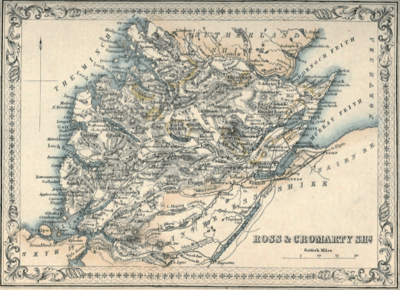
Geography
Sources tend to number the tracts added to Cromartyshire at between eight and eleven;[14][18][19] however some comprise multiple parcels. In 1807, Alexander Nimmo listed the additions in eight groups with two to six parcels in each.[20][21]
Ordnance Survey list
The 1881 index to the Ordnance Survey's first edition lists 22 detached parts, and the original "old shire", all of whose areas are given on the six-inch map.[22] The total measured area of Cromartyshire was 217321.186 acres, or 339.56 square miles (879.5 km2).[23]
| No. [n 1] |
Area (acres) | Name[n 2] | Type[n 2] | Location[n 3] | Parish[n 4][24] | Coords[n 5] | OS[n 6] | Settlements | Notes |
|---|---|---|---|---|---|---|---|---|---|
| [n 7] | 20,191.689[n 8] | Old shire | Barony and six adjacent farms | Black Isle | Cromarty (all), Resolis | 57°39′07″N 4°06′47″W / 57.652°N 4.113°W | 94 SE and 93 NW | Cromarty, Jemimaville, Cullicudden | Encloses an exclave of Ross-shire at Balblair. The six farms, annexed for Viscount Tarbat, are: Cullicudden, Craighouse, Torbirchurn, Brae, Woodhead, and Easter Culbo.[21] |
| 1 | 721.998[a 3] | Plaids | Farm | Easter Ross east; Dornoch Firth shore northeast of Tain | Tain | 57°48′58″N 4°02′06″W / 57.816°N 4.035°W | 94 | Includes the mussel beds in the tidal flats. | |
| 2 | 1,722.235[a 4] | Baliacherie | Farm | Easter Ross east; Dornoch Firth shore northeast of Tain | Tain | 57°49′26″N 4°00′29″W / 57.824°N 4.008°W | 94 | Borders on Morrich More | |
| 3 | 410.106[a 5] | Hillton alias Skardy | Farm and mills | Easter Ross east; Southeast of Tain | Tain | 57°47′49″N 4°01′52″W / 57.797°N 4.031°W | 94 | Mills near Hilton | |
| 4 | 1,585.552[a 6] | Lochslin | Estate | Easter Ross east; Between Inver and Loch Eye | Tain, Fearn | 57°49′N 3°56′W / 57.81°N 3.94°W | 94 | Inver, Lochslin | |
| 5 | 1,867.811[a 7] | Easter Aird and Easter Tarbat | Barony | Easter Ross east; NW of Tarbat peninsula | Tarbat | 57°50′N 3°48′W / 57.84°N 3.80°W | 94 | Portmahomack | Tarbat Ness Lighthouse. Encloses an exclave of Ross-shire at Hilton |
| 6 | 832.897[a 8] | Meikle Tarrel | Barony | Easter Ross east; Moray Firth coast of Tarbat peninsula | Tarbat | 57°48′22″N 3°50′53″W / 57.806°N 3.848°W | 94 | ||
| 7 | 1,211.256[n 9] | Cadboll with Mid Geanies | Estate | Easter Ross east; Moray Firth coast of Tarbat peninsula | Fearn, Tarbat | 57°47′N 3°53′W / 57.78°N 3.88°W | 94 | Hilton of Cadboll is across the border | |
| 8 | 502.969[a 11] | Priesthill | Easter Ross east; East of Kilmuir by Tullich | Kilmuir Easter | 57°44′N 4°08′W / 57.74°N 4.13°W | 94 | Tullich | ||
| 9 | 5,038.255[a 12] | New Tarbat | Estate | Easter Ross east; North of Nigg Bay round Kilmuir | Kilmuir Easter, Nigg | 57°44′06″N 4°03′58″W / 57.735°N 4.066°W | 94 | Kilmuir, Milton, Kildary | Includes Tarbat House, on the site of Milntown Castle. Balnagown Castle is across the border. |
| 10 | 117,047.698[a 13] | Coigach | Wester Ross northwest | Lochbroom, Kincardine | 58°00′N 5°12′W / 58°N 5.2°W | 101, 102 W | Ullapool; Polglass, Achiltibuie, Polbain, Achnahaird, Altandhu, Reiff, Ardnagoine, Achduart, Ardmair, Rhue, Strathkanaird, Morefield | Also includes the Summer Isles, Isle Martin, and Inverpolly | |
| 11 | 1,766.024[a 14] | Amatnatua | Farm | Interior north; south of the River Carron, east of Forest of Amat | Kincardine | 57°52′41″N 4°33′43″W / 57.878°N 4.562°W | 102 S, 93 N | ||
| 12 | 2,272.798[a 15] | Dounie | Farm | Interior north; south of the River Carron by Srath nan Seasgach | Kincardine | 57°53′N 4°26′W / 57.88°N 4.43°W | 93 N, 102 S | ||
| 13 | 51.689[a 16] | Southern tenth[a 17] of Gruinard Island | Farm (part of Meikle Gruinard) | Wester Ross northwest; in Gruinard Bay | Lochbroom | 57°53′N 5°28′W / 57.88°N 5.47°W | 101 SW | ||
| 14 | 1,876.588[a 18] | Meikle Gruinard | Farm (part) | Wester Ross northwest; SE shore of Gruinard Bay | Lochbroom | 57°52′N 5°26′W / 57.87°N 5.44°W | 92, 101 | ||
| 14a | 2,457.315[a 19] | North shore of Little Loch Broom[n 10] | Wester Ross northwest | Lochbroom | 57°54′N 5°20′W / 57.90°N 5.33°W | 101 | Carnach, Scoraig | ||
| 15 | 9,174.142[a 20] | Ach ta Skailt | Wester Ross northwest; Shores round the head (southeast) of Little Loch Broom | Lochbroom | 57°50′N 5°15′W / 57.84°N 5.25°W | 92 N, 101 S | Camusnagaul, Dundonnell | Badrallach is over the border. | |
| 16 | 1,274.932[a 21] | Ach'-n-ivie | Shieling | Interior; Northwest of Loch na Sheallaig | Lochbroom | 57°49′N 5°22′W / 57.82°N 5.37°W | 92 | Lochbroom | |
| 17 | 361.769[a 22] | Feithean Beag[n 11] | Interior; between Strathbeg River and Carn a'Bhreabadar | Lochbroom | 57°48′N 5°10′W / 57.80°N 5.16°W | 92 | |||
| 18 | 11,064.266[a 23] | Nid | Sheep-farm | Interior; northeast from Loch an Nid to the head of Loch Broom | Lochbroom | 57°45′N 5°08′W / 57.75°N 5.13°W | 92 | Inverbroom, Achlunachan | |
| 19 | 1,763.326[a 24] | Tollomuick | Farm | Interior, at the head of Strathvaich | Fodderty | 57°47′N 4°48′W / 57.78°N 4.80°W | 93 W | ||
| 20 | 15,857.571[a 25] | Fannich | Sheep-farm | Interior; North of Loch Fannich | Lochbroom | 57°41′N 5°02′W / 57.68°N 5.03°W | 92 | ||
| 21 | 18,268.300[a 26] | Castle Leod or Strathpeffer | Barony | Easter Ross south | Fodderty | 57°36′N 4°29′W / 57.60°N 4.49°W | 93 S, 83 N | Strathpeffer, Achterneed, Fodderty, Bottacks | Includes much of Ben Wyvis and its southern and western slopes |
- ↑ "Detached portion no." in OS one-inch and 6-inch maps
- 1 2 From Nimmo's 1807 list, unless otherwise noted
- ↑ Location is given as general area [Black Isle, Easter Ross, or Wester Ross], then Parish(es), then adjacent feature(s)
- ↑ Which 1880s civil parish(es) included the fragment. Subsequent parish boundary revisions are ignored. If one parish is listed, it includes the entire fragment. Unless "all" is listed, only part of the parish is in the fragment, with the rest in Ross-shire or other fragments of Cromartyshire.
- ↑ longitude and latitude (link to external mapping sites)
- ↑ Sheet number(s) within the Ross and Cromarty sheet series of the first-edition 1-inch OS map on which the fragment is depicted, and relative location within the map-sheet(s)
- ↑ The "old shire" is considered the core, from which the other parts are "detached"
- ↑ 8674.794 in Cromarty parish[a 1] plus 11516.895 in Resolis parish[a 2]
- ↑ Area is written across two sheets: 1211... in one[a 9] and ....256 in the other.[a 10]
- ↑ Tract not listed by Nimmo.
- ↑ Name on OS one-inch map; tract not listed by Nimmo.
Other sources
Some places not included within Cromartyshire in the Ordnance Survey map are stated by earlier sources to have been within it. The 1859 edition of the Encyclopedia Britannica asserts that Royston Park (now Caroline Park) outside Edinburgh, the city residence of the Viscount Tarbat, was also considered part of Cromartyshire.[18] Nimmo's 1807 list includes:[21]
- "the mortified lands of the town of Fortrose", two patches totalling less than 50 acres in Rosemarkie parish, which were bequeathed to the burgh of Cromarty. A 1794 account of Rosemarkie parish states that there are two mortifications, but for the poor of Chanonry, not Cromarty.[25]
- Ussie Mills (between Dingwall and Conon Bridge).
- salmon-fishing rights on the River Conon.
References
- Mackenzie, Sir George Steuart (1810). General View of the Agriculture of the Counties of Ross and Cromarty: With Observations on the Means of Their Improvement. Richard Phillips.
- Groome, Francis H. (1892–6). Ordnance Gazetteer of Scotland (Revised ed.). London: William McKenzie. Check date values in:
|date=(help)
- 1 2 3 4 Mackenzie 1810, pp.11–13
- ↑ Wilson, John Marius (1854). The Imperial gazetteer of Scotland. Vol.I. pp. 322–3. Retrieved 7 July 2013.
- ↑ "Legislation: final legislation published outwith the parliamentary register". Records of the Parliaments of Scotland to 1707. University of St Andrews. 11 March 1504. Retrieved 12 April 2013.
- ↑ "Act anent the shire of Ross". Records of the Parliaments of Scotland. Edinburgh: University of St Andrews. 5 April 1661. Retrieved 30 March 2013.
- ↑ "Resolis Parish". ScotlandsPlaces. Retrieved 28 March 2013.
- 1 2 3 4 Hayton, D. W. (2002). "Cromartyshire 1690–1715". History of Parliament Online. Retrieved 29 March 2013.
- 1 2 3 4 5 Mackenzie 1810, pp.15–16
- ↑ "Act dissolving the barony of Tarbat from the shire of Ross". Records of the Parliaments of Scotland. Edinburgh: University of St Andrews. 4 June 1685. Retrieved 30 March 2013.
- ↑ "Act in favour of Sir George MacKenzie of Rosehaugh, lord advocate". Records of the Parliaments of Scotland. Edinburgh: University of St Andrews. 4 June 1685. Retrieved 30 March 2013.
- ↑ "Act rescinding a former act annexing lands in Ross-shire to Cromarty". Records of the Parliaments of Scotland. Edinburgh: University of St Andrews. 14 June 1686. Retrieved 30 March 2013.
- ↑
- "Act in favour of [George MacKenzie], viscount of Tarbat". Records of the Parliaments of Scotland. Edinburgh: University of St Andrews. 19 July 1690. Retrieved 30 March 2013.
- "Act rescinding several acts of parliament". Records of the Parliaments of Scotland. Edinburgh: University of St Andrews. 19 July 1690. Retrieved 30 March 2013.
- 1 2 Fisher, David R. (2009). "Cromartyshire 1820–1832". History of Parliament Online. Retrieved 29 March 2013.
- ↑ Her Majesty’s Law Commissioners, Scotland (1839). "Appendix; Return by John Jardine, Esq., Sheriff of Ross and Cromarty". Fourth Report. Command papers. C 241. p. 186.
- 1 2 Ordnance Gazetteer of Scotland, Vol.2 p.310–1, Cromartyshire
- ↑ Walker, David M. (2001-12-01). A legal history of Scotland. Vol.6. W. Green. p. 356. ISBN 9780406948540.
- ↑ Mackenzie 1810, p.19
- ↑ Ordnance Gazetteer of Scotland, Vol.6 p.615, Administration (H.A. Webster)
- 1 2 "Ross and Cromarty". The Encyclopaedia Britannica. XIX (8th ed.). Black. 1859. p. 425.
- ↑ Bryce, James (1862). "Cromarty". The family gazetteer and atlas of the world. William and Alexander Keith Johnston. p. 272. Retrieved 28 March 2013.
- ↑ Fraser, William (1876). The earls of Cromartie : their kindred, country, and correspondence. Vol.2. Edinburgh. pp. 460–462.
- 1 2 3 Mackenzie 1810, pp.16–18
- ↑ Adams, Brian. "The scattered county of Cromartyshire" (PDF). Sheetlines (29): 31–32.
- ↑ Sum of the areas of the 23 parcels listed in the table.
- ↑ The civil parish boundaries and fragment boundaries are shown on the 1-inch maps given in the "OS" column.
- ↑ Wood, Alexander (1794). "26: Rosemarkie". In Sir John Sinclair. The statistical account of Scotland: Drawn up from the communications of the ministers of the different parishes. 11. W. Creech. pp. 344–5. Retrieved 2 April 2013.
- Areas are shown the first-edition 6-inch maps:
- ↑ Cromarty parish
- ↑ Resolis parish
- ↑ Det pt. 1
- ↑ Det pt. 2
- ↑ Det pt. 3
- ↑ Det pt. 4
- ↑ Det pt. 5
- ↑ Det pt. 6
- ↑ Det pt. 7: Sheet 42
- ↑ Det pt. 7: Sheet 43
- ↑ Det pt. 8
- ↑ Det pt. 9
- ↑ Det pt. 10
- ↑ Det pt. 11
- ↑ Det pt. 12
- ↑ Det pt. 13
- ↑ Area of Gruinard I.
- ↑ Det pt. 14
- ↑ Det pt. 14a
- ↑ Det pt. 15
- ↑ Det pt. 16
- ↑ Det pt. 17
- ↑ Det pt. 18
- ↑ Det pt. 19
- ↑ Det pt. 20
- ↑ Det pt. 21
External links
| Wikimedia Commons has media related to Ross and Cromarty. |
- "History of Cromartyshire, in Highland and Scotland". A Vision of Britain through Time. University of Portsmouth: GB Historical GIS. Retrieved 7 July 2013.
- Cromartyshire on the interactive map of the counties of Great Britain and Ireland — Wikishire