Dunbartonshire
Coordinates: 55°58′N 4°32′W / 55.96°N 4.53°W
| Dunbartonshire | |
|---|---|
 |
| Dumbarton | |
|---|---|
| County (until circa 1890) | |
 | |
| Country | Scotland |
| County town | Dumbarton |
| Area | |
| • Total | 625 km2 (241 sq mi) |
| Ranked 29th | |
| Chapman code | DNB |
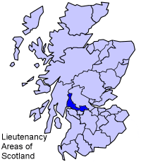
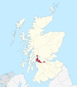
Dunbartonshire (Siorrachd Dhùn Bhreatainn in Gaelic) or the County of Dumbarton is a lieutenancy area and registration county in the west central Lowlands of Scotland lying to the north of the River Clyde.
It was a county used as a primary unit of local government with its administrative centre at the town of Dumbarton. In 1975 the administration section was transferred to the Council.
The area had been previously been part of the historic district of Lennox, which was a duchy in the Peerage of Scotland related to the Duke of Lennox.
Name
Dumbarton comes from the Scottish Gaelic Dùn Breatainn meaning "fort of the Britons".[1]
Historically, the spelling of the county town and the county were not standardised. By the 18th century the names "County of Dunbarton" and "County of Dumbarton" were used interchangeably.[2]
Different county bodies used the two spellings: the Dunbarton County Constabulary were formed in 1857 by the Commissioners of Supply for the County of Dunbarton.[3]
Dumbartonshire County Council, set up under the Local Government (Scotland) Act 1889, adopted the spelling "Dunbartonshire" by 1914, a fact recognised by the Local Government (Scotland) Act 1947.[4][5]
Council
In modern local government, the county is divided into two council areas of Scotland, namely :
- East Dunbartonshire, with its administrative headquarters at Kirkintilloch
- West Dunbartonshire, with its administrative centre at Dumbarton.
The administrative arm, but not the placename of county used for "local government" purposes was dis-established in 1975 by the Local Government (Scotland) Act 1973, when the Administrative Section became part of the large Council of Strathclyde Region.
Strathclyde was divided into nineteen districts, with the area being divided between Dumbarton, Bearsden and Milngavie, Clydebank, Cumbernauld and Kilsyth and Strathkelvin Districts, the latter also containing a small part of the former Lanarkshire.
The regional identity, the "place-name" was retained for some major functions such as fire service and police at the next reorganisation of local government in 1996.
The county then was administered by three new unitary councils:
- Argyll and Bute Council (which took over the Helensburgh and Lomond part of Dumbarton District)
- East Dunbartonshire Council
- West Dunbartonshire Council
Cumbernauld was not included in either of the new Dunbartonshire councils, instead being placed in the North Lanarkshire area.
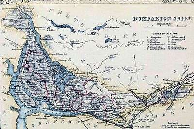
Boundaries
The county retained a large exclave despite the boundary changes in the 1890s elsewhere in Scotland, consisting of the civil parishes of Kirkintilloch and Cumbernauld, between Stirlingshire and Lanarkshire : this area had originally been part of Stirlingshire, but had been annexed to Dunbarton in the reign of David II at the request of Malcolm Fleming, Earl of Wigtown, the owner of the land, who was also Sheriff of Dumbarton.[6]
The exclave was dealt with in 19th century legislation as greater administrative duties were given to the counties.
The Police (Scotland) Act 1857 established police forces throughout Scotland. A section of the act allowed for the parishes to be transferred to the jurisdiction of either Stirlingshire or Lanarkshire Constabulary on resolution of two thirds of the Commissioners of Supply for the County of Dumbarton.[7]
Similar provisions allowing for the transfer of the area for all purposes were included in the County General Assessment (Scotland) Act 1868.[8] No such resolution was made, and the two parishes remained in Dumbartonshire.
The Roads and Bridges (Scotland) Act 1878 provided that for the purposes of that act all detached parts of counties should be placed in the county by which they were surrounded, or with which they had the longest boundary.[9] Accordingly, Cumbernauld and Kirkintilloch came under the control of the Stirlingshire Road Board. It was originally anticipated that the area would be transferred to Stirlingshire for all other purposes by the boundary commissioners proposed by the Local Government Bill of 1889[10] However, a clause was inserted in the bill that stated "the parishes of Cumbernauld and Kirkintilloch, including the burghs and police burghs situate therein, shall for the purposes of this Act, be considered as forming part of the county of Dumbarton". The clause was vigorously opposed by the Stirlingshire Commissioners of Supply as they had incurred considerable expense in maintaining the roads of the two parishes. The Act as passed provided that the Dunbartonshire County Council was to financially compensate Stirlingshire on the transfer of road powers.[11]
Settlements
Towns
- Alexandria
- Balloch
- Bearsden
- Clydebank
- Cumbernauld
- Dumbarton
- Helensburgh
- Kirkintilloch
- Lenzie
- Milngavie
Villages and hamlets
- Aldochlay
- Ardlui
- Arrochar
- Auchinstarry
- Bonhill
- Bowling
- Cardross
- Clynder
- Cove
- Croftamie
- Croy
- Duntocher
- Garelochhead
- Gartocharn
- Hardgate
- Inverbeg
- Inveruglas
- Jamestown
- Kilcreggan
- Luss
- Milton
- Old Kilpatrick
- Renton
- Rhu
- Rosneath
- Shandon
- Tarbet
- Twechar
Civil Parishes
- Arrochar
- Bonhill
- Cardross
- Craigrownie
- Cumbernauld
- Dalreoch
- Dumbarton
- Kilmaronock
- Kirkintilloch
- Luss
- New Kilpatrick
- Old Kilpatrick
- Renton
- Rhu
- Rosneath
- Rossdhu
Surnames
Most common surnames in Dunbartonshire at the time of the United Kingdom Census of 1881,[12] by order of incidence:
- 1. Campbell
- 2. Smith
- 3. Stewart
- 4. Brown
- 5. Wilson
- 6. McFarlane
- 7. McDonald
- 8. Thomson
- 9. Cameron
- 10. McIntyre
References
- ↑ "Visions of Britain".
- ↑ See for instance Crown Lands - Forfeited Estates Act, 1784 (1784 c. 57) and Manning of the Navy Act, 1795 (1795 c. 29)
- ↑ Edinburgh Gazette, Issue 6736, published 15 September 1857
- ↑ Edinburgh Gazette, Issue 12743, published 24 November 1914
- ↑ Local Government (Scotland) Act 1947 (1947 c. 43)
- ↑ Cumbernauld, A Topographical Dictionary of Scotland (1846)(British History Online)
- ↑ Police (Scotland) Act 1857 (C.72) s.70
- ↑ 1868 (C.82) s.6
- ↑ Roads and Bridges (Scotland) Act 1878 C.51, S.40
- ↑ "Local Government (Scotland) Bill No.179 (HL Deb 06 August 1889 vol 339 cc447-531)". Hansard, Lords Sitting. 1889-08-06. Retrieved 2008-06-30.
- ↑ Local Government (Scotland) Act 1889 1889 (c. 50) s.40
- ↑ Most Common Surnames in Dunbartonshire
| Wikimedia Commons has media related to Dumbartonshire. |
History of Dumbartonshire
- "The Book of Dumbartonshire", J. Scott Keltie in Macmillan's Magazine, Vol. LXII, May to Oct., 1880, pp. 33–42
- A Short History of Dumbartonshire I.M.M. MacPhail