Cucharas Pass
| Cucharas Pass | |
|---|---|
|
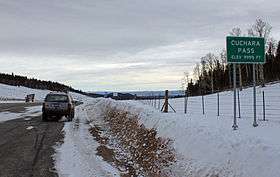
The pass in December, 2012. | |
| Elevation | 9,938 ft (3,029 m)[1] |
| Traversed by |
|
| Location | Las Animas / Huerfano counties, Colorado, United States |
| Range | Sangre de Cristo Mountains |
| Coordinates | 37°19′13″N 105°04′25″W / 37.32028°N 105.07361°WCoordinates: 37°19′13″N 105°04′25″W / 37.32028°N 105.07361°W |
| Topo map | USGS Cucharas Pass |
Cucharas Pass is a 9,938 ft (3,029 m) elevation mountain pass in the Sangre de Cristo Mountains in south central Colorado in the United States.
At the top, the pass is signed as Cuchara Pass and the elevation on the sign there reads 9995 ft. State Highway 12 traverses the pass. Highway 12 is also signed as the Highway of Legends Scenic Byway, one of Colorado's Scenic and Historic Byways.
References
- ↑ "Cucharas Pass". Geographic Names Information System. United States Geological Survey. Retrieved 2011-02-02.
This article is issued from Wikipedia - version of the 6/18/2014. The text is available under the Creative Commons Attribution/Share Alike but additional terms may apply for the media files.