Las Animas County, Colorado
| Las Animas County, Colorado | |
|---|---|
|
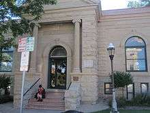
Las Animas County Courthouse in Trinidad | |
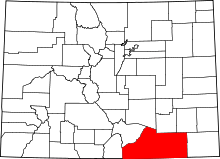 Location in the U.S. state of Colorado | |
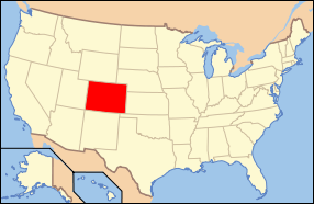 Colorado's location in the U.S. | |
| Founded | February 9, 1866 |
| Named for | Animas River |
| Seat | Trinidad |
| Largest city | Trinidad |
| Area | |
| • Total | 4,775 sq mi (12,367 km2) |
| • Land | 4,773 sq mi (12,362 km2) |
| • Water | 2.7 sq mi (7 km2), 0.06% |
| Population (est.) | |
| • (2015) | 14,058 |
| • Density | 3.2/sq mi (1/km²) |
| Congressional district | 4th |
| Time zone | Mountain: UTC-7/-6 |
| Website |
lasanimascounty |

Las Animas County is one of the 64 counties in the U.S. state of Colorado. As of the 2010 census, the population was 15,507.[1] The county seat is Trinidad.[2] The county takes its name from the Mexican Spanish name of the Purgatoire River, originally called El Río de las Ánimas Perdidas en Purgatorio, which means "River of the Lost Souls in Purgatory."[3]
Geography
According to the U.S. Census Bureau, the county has a total area of 4,775 square miles (12,370 km2), of which 4,773 square miles (12,360 km2) is land and 2.7 square miles (7.0 km2) (0.06%) is water.[4] It is the largest county by area in Colorado.
Adjacent counties
- Otero County - north
- Pueblo County - north
- Bent County - northeast
- Baca County - east
- Union County, New Mexico - south
- Colfax County, New Mexico - southwest
- Costilla County- west
- Huerfano County - northwest
Protected areas
- Comanche National Grassland
- Lake Dorothey State Wildlife Area
- James M. John State Wildlife Area
- San Isabel National Forest
- Spanish Peaks Wilderness
- Trinidad Lake State Park
Historic trails and landmarks
- Mesa de Maya
- Raton Pass National Historic Landmark
- Santa Fe National Historic Trail
- Trinidad State History Museum
Scenic byways
Demographics
| Historical population | |||
|---|---|---|---|
| Census | Pop. | %± | |
| 1870 | 4,276 | — | |
| 1880 | 8,903 | 108.2% | |
| 1890 | 17,208 | 93.3% | |
| 1900 | 21,842 | 26.9% | |
| 1910 | 33,643 | 54.0% | |
| 1920 | 38,975 | 15.8% | |
| 1930 | 36,008 | −7.6% | |
| 1940 | 32,369 | −10.1% | |
| 1950 | 25,902 | −20.0% | |
| 1960 | 19,983 | −22.9% | |
| 1970 | 15,744 | −21.2% | |
| 1980 | 14,897 | −5.4% | |
| 1990 | 13,765 | −7.6% | |
| 2000 | 15,207 | 10.5% | |
| 2010 | 15,507 | 2.0% | |
| Est. 2015 | 14,058 | [5] | −9.3% |
| U.S. Decennial Census[6] 1790-1960[7] 1900-1990[8] 1990-2000[9] 2010-2015[1] | |||
As of the census[10] of 2000, there were 15,207 people, 6,173 households, and 4,092 families residing in the county. The population density was 3 people per square mile (1/km²). There were 7,629 housing units at an average density of 2 per square mile (1/km²). The racial makeup of the county was 82.63% White, 0.39% Black or African American, 2.54% Native American, 0.37% Asian, 0.20% Pacific Islander, 10.03% from other races, and 3.83% from two or more races. 41.45% of the population were Hispanic or Latino of any race.
There were 6,173 households out of which 28.80% had children under the age of 18 living with them, 49.90% were married couples living together, 11.60% had a female householder with no husband present, and 33.70% were non-families. 29.70% of all households were made up of individuals and 14.30% had someone living alone who was 65 years of age or older. The average household size was 2.40 and the average family size was 2.97.
In the county the population was spread out with 24.20% under the age of 18, 7.90% from 18 to 24, 24.00% from 25 to 44, 25.90% from 45 to 64, and 18.00% who were 65 years of age or older. The median age was 41 years. For every 100 females there were 95.80 males. For every 100 females age 18 and over, there were 93.70 males.
The median income for a household in the county was $28,273, and the median income for a family was $34,072. Males had a median income of $27,182 versus $20,891 for females. The per capita income for the county was $16,829. About 14.00% of families and 17.30% of the population were below the poverty line, including 20.00% of those under age 18 and 17.20% of those age 65 or over.
Communities

City
Towns
Census-designated places
Unincorporated communities
Ghost towns
See also
- Outline of Colorado
- Index of Colorado-related articles
- Colorado census statistical areas
- Arthur Roy Mitchell
- National Register of Historic Places listings in Las Animas County, Colorado
References
- 1 2 "State & County QuickFacts". United States Census Bureau. Retrieved February 11, 2014.
- ↑ "Find a County". National Association of Counties. Retrieved 2011-06-07.
- ↑ Gannett, Henry (1905). The Origin of Certain Place Names in the United States. U.S. Government Printing Office. p. 182.
- ↑ "US Gazetteer files: 2010, 2000, and 1990". United States Census Bureau. 2011-02-12. Retrieved 2011-04-23.
- ↑ "County Totals Dataset: Population, Population Change and Estimated Components of Population Change: April 1, 2010 to July 1, 2015". Retrieved July 2, 2016.
- ↑ "U.S. Decennial Census". United States Census Bureau. Retrieved June 8, 2014.
- ↑ "Historical Census Browser". University of Virginia Library. Retrieved June 8, 2014.
- ↑ "Population of Counties by Decennial Census: 1900 to 1990". United States Census Bureau. Retrieved June 8, 2014.
- ↑ "Census 2000 PHC-T-4. Ranking Tables for Counties: 1990 and 2000" (PDF). United States Census Bureau. Retrieved June 8, 2014.
- ↑ "American FactFinder". United States Census Bureau. Retrieved 2011-05-14.
External links
 |
Huerfano County | Otero County and Pueblo County | Bent County | |
| Costilla County | |
Baca County | ||
| ||||
| | ||||
| Colfax County, New Mexico | Union County, New Mexico |
Municipalities and communities of Las Animas County, Colorado, United States | ||
|---|---|---|
| City | | |
| Towns | ||
| CDPs | ||
| Unincorporated communities | ||
| Ghost towns | ||

Coordinates: 37°19′N 104°02′W / 37.32°N 104.04°W