Curry, Walker County, Alabama
| Curry, Alabama | |
|---|---|
| Unincorporated community | |
 Curry, Alabama  Curry, Alabama | |
| Coordinates: 33°57′13″N 87°12′52″W / 33.95361°N 87.21444°WCoordinates: 33°57′13″N 87°12′52″W / 33.95361°N 87.21444°W | |
| Country | United States |
| State | Alabama |
| County | Walker |
| Elevation | 623 ft (190 m) |
| Time zone | Central (CST) (UTC-6) |
| • Summer (DST) | CDT (UTC-5) |
| Area code(s) | 205 |
| GNIS feature ID | 159474[1] |
Curry is an unincorporated community in north-central Walker County Alabama, United States.[1] It is the closest community to the Lewis Smith Lake dam. Curry is served by Alabama State Route 257, which is simply known as Curry Highway by locals.
Education
Curry High School is a 5A school, serving grades 9-12.[2] The school colors are Blue and Gold with the mascot being the Yellow Jacket. It is a member of the Walker County Board of Education.[3]
Notable person
- Charles Martin, Alabama politician
References
Municipalities and communities of Walker County, Alabama, United States | ||
|---|---|---|
| Cities | 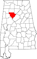 | |
| Towns | ||
| Unincorporated communities | ||
| Footnotes | ‡This populated place also has portions in an adjacent county or counties | |
This article is issued from Wikipedia - version of the 7/31/2016. The text is available under the Creative Commons Attribution/Share Alike but additional terms may apply for the media files.