Déléage, Quebec
| Déléage | |
|---|---|
| Municipality | |
 | |
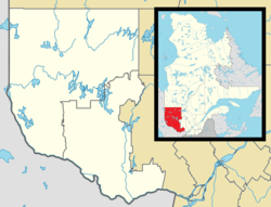 Déléage Location in western Quebec. | |
| Coordinates: 46°23′N 75°55′W / 46.383°N 75.917°WCoordinates: 46°23′N 75°55′W / 46.383°N 75.917°W[1] | |
| Country |
|
| Province |
|
| Region | Outaouais |
| RCM | La Vallée-de-la-Gatineau |
| Constituted | January 1, 1881 |
| Government[2] | |
| • Mayor | Jean-Paul Barbe |
| • Federal riding | Pontiac |
| • Prov. riding | Gatineau |
| Area[2][3] | |
| • Total | 265.70 km2 (102.59 sq mi) |
| • Land | 249.09 km2 (96.17 sq mi) |
| Population (2011)[3] | |
| • Total | 1,856 |
| • Density | 7.5/km2 (19/sq mi) |
| • Pop (2006–11) |
|
| • Dwellings | 967 |
| Time zone | EST (UTC−5) |
| • Summer (DST) | EDT (UTC−4) |
| Postal code(s) | J9E 3A8 |
| Area code(s) | 819 |
| Website |
www |
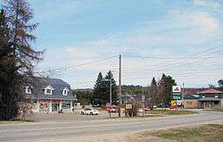
Déléage is a town and municipality in La Vallée-de-la-Gatineau Regional County Municipality, Quebec, Canada. It is situated on the eastern banks of the Gatineau River opposite Maniwaki.
Deleage and Deléage are frequently used alternate spellings.[4] The official spelling was changed from Deleage to Déléage on March 20, 2004.[5]
History
In 1871, the Kensington Township was proclaimed, named after a district of West London, England. In 1881, the Township Municipality of Kensington was formed. In 1930, it was renamed to Déléage, in honour of Jean-Francois-Regis Déléage (1821-1884), born in Haute-Loire and missionary in the Outaouais from 1853 to 1879, where he founded a dozen parishes. His name has also been used to identify the post office between 1929 and 1967.[4]
Demographics
Population trend:[6]
- Population in 2011: 1856 (2006 to 2011 population change: -5.5 %)
- Population in 2006: 1964
- Population in 2001: 2053 (R)
- 2001 to 2006 population change: -4.3 %
- Population in 1996: 2036
- Population in 1991: 1921
(R) = Revised count.[7]
Private dwellings (occupied by usual residents): 824
Languages:
- English as first language: 3%
- French as first language: 94%
- English and French as first language: 1%
- Other as first language: 2%
References
- ↑ Reference number 176541 of the Commission de toponymie du Québec (French)
- 1 2 Geographic code 83070 in the official Répertoire des municipalités (French)
- 1 2 "(Code 2483070) Census Profile". 2011 census. Statistics Canada. 2012.
- 1 2 "Municipalité de Déléage" (in French). Commission de toponymie du Québec. Retrieved 2008-07-23.
- ↑ http://www.stat.gouv.qc.ca/publications/referenc/pdf/ModMars04.pdf
- ↑ Statistics Canada: 1996, 2001, 2006, 2011 census
- ↑ Statistics Canada - Population and dwelling count amendments to the 2001 Census
 |
Egan-Sud | Aumond | Mont-Laurier | |
| Maniwaki Kitigan Zibi (Maniwaki 18) |
|
Notre-Dame-de-Pontmain | ||
| ||||
| | ||||
| Messines | Sainte-Thérèse-de-la-Gatineau |
| Cities | |
|---|---|
| Municipalities | |
| Townships | |
| Unorganized territories | |
| |