DODGE (satellite)
 The DODGE satellite | |
| Mission type | Technology |
|---|---|
| Operator | NASA / USAF |
| COSPAR ID | 1967-066F |
| SATCAT № | 2867 |
| Mission duration | 3 years |
| Spacecraft properties | |
| Manufacturer |
Johns Hopkins University Applied Physics Laboratory |
| Launch mass | 200 kilograms (430 lb) |
| Dimensions | 2.4 by 1.2 metres (7.9 by 4.0 ft) |
| Start of mission | |
| Launch date | July 1, 1967, 13:15:01 UTC |
| Rocket | Titan IIIC |
| Launch site | Cape Canaveral LC-41 |
| Orbital parameters | |
| Reference system | Geocentric |
| Regime | MEO |
| Semi-major axis | 39,841.6 kilometres (24,756.4 mi) |
| Perigee | 33,278.8 kilometres (20,678.5 mi) |
| Apogee | 33,662.5 kilometres (20,916.9 mi) |
| Inclination | 11.6 degrees |
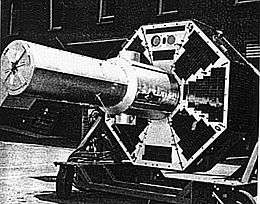
DODGE (Department of Defense Gravity Experiment) was a satellite whose primary purpose was to conduct experiments in gravity-gradient stabilization at near-geosynchronous altitudes. Its secondary objectives included measuring the Earth's magnetic field, and taking pictures of the entire Earth's disk in both black-and-white and color. It was launched atop a Titan IIIC rocket on July 1st, 1967 and operated for over three years. DODGE carried ten knobbed booms oriented along three different axes, that could be independently extended and retracted by ground command.[1]
DODGE first achieved successful stabilization 12 days after launch,[1] and took one of the first color pictures of the complete Earth disk.[2]
.png)
The first color image of the entire Earth, taken by the DODGE satellite
References
See also
This article is issued from Wikipedia - version of the 6/2/2016. The text is available under the Creative Commons Attribution/Share Alike but additional terms may apply for the media files.