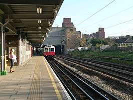
Dagenham Heathway tube station
| Dagenham Heathway | |
|---|---|
|
Westbound platform | |
 Dagenham Heathway Location of Dagenham Heathway in Greater London | |
| Location | Dagenham |
| Local authority | London Borough of Barking and Dagenham |
| Managed by | London Underground |
| Number of platforms | 2 |
| Accessible | Yes [1] |
| Fare zone | 5 |
| London Underground annual entry and exit | |
| 2012 |
|
| 2013 |
|
| 2014 |
|
| 2015 |
|
| Key dates | |
| 1932 | Opened by London, Midland and Scottish Railway |
| 1948 | Ownership transferred to British Railways |
| 1969 | Ownership transferred to London Transport |
| Other information | |
| Lists of stations | |
| WGS84 | 51°32′30″N 0°08′49″E / 51.54166°N 0.14694°ECoordinates: 51°32′30″N 0°08′49″E / 51.54166°N 0.14694°E |
|
| |
Dagenham Heathway is a London Underground station on the District line located in the London Borough of Barking and Dagenham. It is in London fare zone 5.
History
The station was opened in 1932. The station was constructed and initially operated by the London, Midland and Scottish Railway with services provided by the District line from the outset. The station was called Heathway when it first opened, changing to its present name in 1949.
Design
It is of similar design to Upney and Elm Park with the platforms arranged on a central island with a long sloping walkway connection to the ticket hall. The 1930s station buildings were extensively refubished during 2005 and 2006.
Location
It is between Becontree and Dagenham East stations in Dagenham.
Services
Typical off-peak service from the station is:
- 12 tph (trains per hour) to Upminster
- 6 tph to Ealing Broadway via Tower Hill
- 6 tph to Richmond via Tower Hill
| Preceding station | Following station | |||
|---|---|---|---|---|
| District line | towards Upminster |
Connections
London Buses routes 173, 174 and 175 serve the station.
References
| Wikimedia Commons has media related to Dagenham Heathway tube station. |
- ↑ "Step free Tube Guide" (PDF). Transport for London. Archived (PDF) from the original on 3 June 2015.
- 1 2 3 4 "Multi-year station entry-and-exit figures" (XLS). London Underground station passenger usage data. Transport for London. April 2016. Retrieved 3 May 2016.
