Dale, Oregon
Dale is an unincorporated community in Grant County, Oregon, United States.[1] It is located on U.S. Route 395 within the Umatilla National Forest about 17 miles south of Ukiah.[2] It is near the Umatilla-Grant County border just south of the 45th parallel north.[2]
The first post office at this locale was established in 1887 and named Dorman after James W. Dorman, the first postmaster.[3] The name was changed to Dale in 1891.[3] The office may have been moved south from its original location in Umatilla County and it was shown as being in Grant County by 1903.[3] According to the compiler of Oregon Geographic Names, who did not think that the local terrain resembled a dale, "The name Dale as applied to this locality may have had a significance other than topographic."[3] Mail for Dale is now handled by the Ukiah post office, ZIP code 97880.[4]
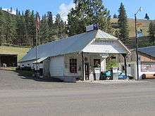
In 1940, Dale had a service station and store that still serves the community today.[5][6] Dale Ranger Station was open by 1911 and closed sometime before 2008.[7][8]
See also
References
- ↑ "Dale". Geographic Names Information System. United States Geological Survey. November 28, 1980. Retrieved February 7, 2012.
- 1 2 Oregon Atlas & Gazetteer (7th ed.). Yarmouth, Maine: DeLorme. 2008. pp. 74, 78. ISBN 0-89933-347-8.
- 1 2 3 4 McArthur, Lewis A.; McArthur, Lewis L. (2003) [1928]. Oregon Geographic Names (7th ed.). Portland, Oregon: Oregon Historical Society Press. p. 265. ISBN 978-0875952772.
- ↑ "ZIP Code Lookup". United States Postal Service. Retrieved February 7, 2012.
- ↑ Writers' Program of the Work Projects Administration in the State of Oregon (1940). Oregon: End of the Trail. American Guide Series. Portland, Oregon: Binfords & Mort. p. 419. OCLC 4874569.
- ↑ "Personal-Use Firewood Permits". Umatilla National Forest. Retrieved February 7, 2012.
- ↑ Groom, Etta (March 2005). "Pioneer Ranger Family at Dale, Oregon" (PDF). National Museum of Forest Service History Newsletter. United States Forest Service. 16 (1). Retrieved February 7, 2012.
- ↑ "Long Creek Eyes Dale FS Site for Campus". Blue Mountain Eagle. May 7, 2008.
External links
- Historic images of directional signs to Dale Ranger Station from Salem Public Library
- Historic image of Dale Ranger Station in 1924 from the U.S. Forest Service
- Images of Dale from Flickr
Coordinates: 44°59′19″N 118°56′51″W / 44.988487°N 118.947474°W
Municipalities and communities of Grant County, Oregon, United States | ||
|---|---|---|
| Cities | 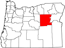 | |
| Unincorporated communities | ||
| Ghost towns | ||