Dan Ryan Expressway
| Dan Ryan Expressway | |
|---|---|
| South Route Expressway | |
| Route information | |
| Maintained by IDOT | |
| Length: | 11.47 mi[1] (18.46 km) |
| Existed: | 1961 – present |
| Component highways: |
|
| Major junctions | |
| North end: |
|
|
| |
| South end: |
|
| Highway system | |
The Dan Ryan Expressway is a freeway in the city of Chicago that runs from the Circle Interchange with I-290 near downtown Chicago through the South Side of the city. It is designated as both Interstate 94 and Interstate 90 south to 66th Street, a distance of 7.44 miles (11.97 km). It then becomes just Interstate 94 at the split with the Chicago Skyway (which leads to Interstate 90), with a remaining distance of 4.03 miles (6.49 km). This is a total distance of 11.47 miles (18.5 km).[1] The freeway was named for Dan Ryan, Jr., a former president of the Cook County Board of Commissioners.
Route description
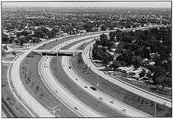
On an average day, up to 307,100 vehicles use a portion of the Dan Ryan (2005 data).[1] The Dan Ryan, and its North Side counterpart the Kennedy Expressway, are the busiest roads in the entire state of Illinois. Utilizing an express-local system, the Dan Ryan has fourteen lanes of traffic; seven in each direction, with four of those as express lanes and the other three providing access for exit and on-ramps. Despite its width, the Dan Ryan is prone to traffic jams.
The posted directions on the Dan Ryan are different from the actual compass direction of the expressway, which may cause confusion to many travelers. The Dan Ryan for its entire 12-mile (19 km) length runs north–south. However, the Dan Ryan is a part of the larger Interstates 90 and 94, which both run east–west through the United States. Therefore, one who is traveling "west" on I-90/94 is actually driving north on the Dan Ryan as it passes through Chicago; I-90 continues northwest from the Kennedy split, while I-94 runs north-south until the Marquette Interchange in Milwaukee. Similarly, "east" on 90 and 94 on the entire system is really south through Chicago; the interstates will continue on an easterly path outside of the city. Chicagoans also typically refer to the direction of travel as either "inbound" or "outbound" from the downtown area.
Four miles of continuous high-rise housing projects (Stateway Gardens and the Robert Taylor Homes) formerly ran parallel to the expressway on its eastern side from Cermak Road south to Garfield Boulevard. However, nearly all of these buildings have been demolished as part of the CHA's transformation plan.
The Red Line runs in the median of the Dan Ryan. This section of the Chicago 'L' opened on September 28, 1969. Chicago pioneered the location of rapid transit line in expressway medians, a practice that has since been followed in several other cities, such as Toronto, Pasadena, CA and Charlotte.[2]
The control cities for the Dan Ryan Expressway are Indiana and Chicago Loop.
History
The first segment of the Dan Ryan, opened on December 12, 1961 and ran between U.S. 12/20, 95th Street north to 71st in the Chicago's Grand Crossing neighborhood. It was named after the recently deceased Dan Ryan Jr., who was President of the Cook County Board of Commissioners who had worked to accelerate construction of Chicago-area expressways. A year later on December 15, 1962, the 8 mile stretch of the Dan Ryan between 71st Street and Interstate 90/Eisenhower Expressway (now signed as 290) opened to the public as well as a 0.2 mile stretch that connected it to the Bishop Ford Freeway. During the planning stages it was also known as the South Route Expressway.[3]
Reconstruction history


In 1988-1989, the northern three miles (5 km) of the Dan Ryan, known as the Elevated Bridge, were completely reconstructed.[4]
In 2006 and 2007, the Illinois Department of Transportation reconstructed the entire length of the Dan Ryan Expressway, including the addition of a travel lane from 47th Street to 95th Street. The project was the largest expressway reconstruction plan in Chicago history. The total cost of the project was US$975 million, nearly twice the US$550 million original estimate for the project.[5][6]
Exit list
The entire route is in Chicago, Cook County.
| mi | km | Exit | Destinations | Notes | |
|---|---|---|---|---|---|
| Continuation beyond I-290 | |||||
| 51.8 | 83.4 | 51H | No exit number westbound | ||
| 51.8 | 83.4 | 51I | Congress Parkway (500 South) – Chicago Loop | Signed as 51H eastbound | |
| 52.1 | 83.8 | 52A | Taylor Street (1000 South), Roosevelt Road (1200 South) | Eastbound exit and westbound entrance | |
| 52.3 | 84.2 | 52B | Roosevelt Road (1200 South), Taylor Street (1000 South) | Westbound exit and eastbound entrance | |
| 52.9 | 85.1 | 52C | 18th Street | Eastbound exit and westbound entrance | |
| 53.0 | 85.3 | 53A | Canalport Avenue, Cermak Road (2200 South) | Westbound exit and eastbound entrance | |
| 53.3 | 85.8 | 53 | Signed as exits 53B (south) and 53C (north) westbound | ||
| Western end of express lanes | |||||
| 53.8 | 86.6 | 53C | Cermak Road (2200 South) | Westbound exit and eastbound entrance | |
| 54.7 | 88.0 | 54 | 31st Street (3100 south) | ||
| 55.2 | 88.8 | 55A | 35th Street | Guaranteed Rate Field, Illinois Institute of Technology | |
| 55.7 | 89.6 | 55B | Pershing Road (3900 South) | ||
| 56.2 | 90.4 | 56A | 43rd Street | ||
| 56.7 | 91.2 | 56B | 47th Street (4700 south) | ||
| 57.7 | 92.9 | 57 | Garfield Boulevard (5500 South) | ||
| 58.2 | 93.7 | 58A | 59th Street | Westbound exit and eastbound entrance | |
| 58.7 | 94.5 | 58B | 63rd Street (6300 south) | Eastbound exit and westbound entrance | |
| 59.0 | 95.0 | 59A | Eastern end of I-90 concurrency; eastbound exit and westbound entrance | ||
| 59.3 | 95.4 | 59B | Marquette Road, 67th Street (6700 South) | Westbound exit and eastbound entrance | |
| Eastern end of express lanes | |||||
| 59.8 | 96.2 | 59C | 71st Street (7100 south) | ||
| 60.3 | 97.0 | 60A | 75th Street | Eastbound exit and westbound entrance | |
| 60.4 | 97.2 | 60B | 76th Street | Westbound exit and eastbound entrance | |
| 60.8 | 97.8 | 60C | 79th Street (7900 south) | ||
| 61.3 | 98.7 | 61A | 83rd Street | Eastbound exit and westbound entrance | |
| 61.8 | 99.5 | 61B | 87th Street (8700 south) | ||
| 62.8 | 101.1 | 62 | Eastbound exit and westbound entrance | ||
| 63.17 | 101.66 | 63 | Eastbound exit and westbound entrance | ||
| — | Eastbound exit and westbound entrance | ||||
1.000 mi = 1.609 km; 1.000 km = 0.621 mi
| |||||
References
- 1 2 3 Illinois Technology Transfer Center (2006). "T2 GIS Data". Archived from the original on August 10, 2007. Retrieved 2007-11-08.
- ↑ Thomas Buck (September 28, 1969). "Ryan rail service starts today". Chicago Tribune.
- ↑ "Daniel Ryan (obituary)". Cook County Highways: 3. April 1961.
- ↑ Hilkevitch, John. Buckle up, it looks like a long ride. Chicago Tribune. Published March 26, 2006. Retrieved March 26, 2006.
- ↑ Haggerty, Ryan (2007-10-26). "All lanes will be open on the Dan Ryan". Chicago Tribune. Retrieved 2007-10-26.
- ↑ Tridgell, Guy (2007-10-18). "Falling gas prices won't stay". Daily Southtown. Archived from the original on 2008-06-05. Retrieved 2007-10-25.
External links
| Wikimedia Commons has media related to Dan Ryan Expressway. |
- Dan Ryan Expressway (I-90 and I-94) at Steve Anderson's ChicagoRoads.com
- Historic, Current & Average Travel Times For The Dan Ryan Expressway