Darling Street
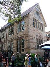
Darling Street, running along the ridge of the Balmain Peninsula in inner-west Sydney, Australia, from the East Balmain Ferry Wharf to Victoria Road, is the main thoroughfare and high street of the suburbs of Balmain and Rozelle, and a noted café and restaurant strip.
Balmain Market is on the corner of Darling and Curtis Road.[1]
History
In 1875, Darling Street received its first instillation of gas lighting. The effect of this was so that during the late 1880s there was an increase of business due to the increase of illumination along the shopping strip at night. Twenty years prior to this the area where the town hall is now located was occupied by bushland.
Trams
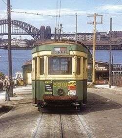
Trams once ran all the way down Darling Street to the Wharf at Balmain East. The first steam tram to service Darling street was in 1892. Ten years later the service was electrified.[2] A feature of this line was a counterweight dummy system that controlled and assisted trams on a steep single-line section of track near the terminus at Darling Wharf. Due to the very steep incline at the bottom of the street, the trams used a complex 'dummy' counterweight system constructed under the road surface. The trams were pushed up the steep hill by the dummy, and rode the dummy on the way down to safely descend the hill.
A cross country connection between the Canterbury Line at New Canterbury Road and the Western Suburbs lines on Parramatta Road allowed for a cross country service to operate between Canterbury train station and Balmain Wharf via Darling Road. The Darling Street tram line was serviced by the Rozelle Tram Depot in Glebe.
Gladstone Park Reservoir
Construction of the Gladstone Park Reservoir was announced in 1912 causing public outcry. The water board reassured residents that the park and bandstand would be restored to its former status once the reservoir was complete. Before construction of the reservoir residents obtained their water supply from backyard wells or water carts. Completed in 1917 the reservoir is still intact and the water is now used for reserve supply only.
See also
![]() Australian Roads portal
Australian Roads portal
References
- ↑ Street Markets in Sydney, Australia Travel Guide.
- ↑ A Pictorial History of Balmain, page 11