Oxford Street, Sydney
 Darlinghurst, 2007 | |
| Location | Sydney, Australia |
|---|---|
| Coordinates | 33°52′44″S 151°12′54″E / 33.87900°S 151.21488°E |
| Other | |
| Known for | Night spot |
Oxford Street is a major thoroughfare in Sydney, Australia, running from Whitlam Square on the south-east corner of Hyde Park in the central business district (CBD) of Sydney to Bondi Junction in the Eastern Suburbs.[1] Close to the CBD in particular, the street is lined with numerous shops, bars and nightclubs. In recent years, Oxford Street has garnered a reputation as Sydney's primary nightclub strip, and has subsequently seen a large increase in the number of crimes committed in the area.
The western section, which runs through the suburb of Darlinghurst, is widely recognised as Sydney's main gay district and Oxford Street is closed to traffic once a year in early March for the Sydney Gay and Lesbian Mardi Gras. The section to the east of Taylor Square, running through the suburb of Paddington forms an upmarket shopping strip and represents the home of the new medical faculty of the University of Notre Dame Australia as well as the University of New South Wales' College of Fine Arts, Victoria Barracks, Paddington Bazaar and St Vincent's Hospital, Sydney amongst other locations.
History
In May 1909 the Sydney Council resolved to widen Oxford Street from 66 feet (20 m) to 100 feet (30 m) by resuming the entire north side of the street between Liverpool and Bourke Streets. The project was carried out in five stages between 1910 and 1914. The result was a new boulevard and the creation of a Federation streetscape which remains today largely intact.
Trams to Bondi and Bronte beaches travelled down Oxford Street until the line was closed in 1960, replaced by the current bus service.
Paddington Reservoir
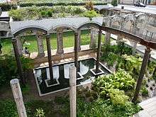
Located on the corner of Oatley Road and Oxford Street is the Paddington Reservoir, a water reservoir which provided water to the Botany Swamps pumping station for the provision of water to parts of Sydney between 1866 and 1899. In 2006 work began to restore and reuse the space of the then derelict Paddington Reservoir. The facility reopened in 2008 as a sunken garden known as the Paddington Reservoir Gardens or Walter Read Reserve, with a rooftop reserve located above the preserved eastern chamber. The facility integrates the remains of the original brick, timber and iron structure with modern elements of sculptural, structural and functional significance which provide access to the sunken garden via stairs and an elevator as well as ramped access to the rooftop reserve.
Victoria Barracks
Victoria Barracks, located in Oxford Street, houses the Headquarters Forces Command (Australia), as well as the Army Museum of NSW which is housed in the original District Military Prison, constructed in 1800. The barracks was constructed of Hawkesbury sandstone by way of convict labour between 1841 and 1846.

The Barracks were originally occupied by regiments of the British Army who vacated the site in 1870. The Barracks was the premier military training site in Australia until 1901. For a brief period during the 1930s Victoria Barracks was home to the Royal Military College, Duntroon when the College was forced to close its buildings in Canberra and relocate to Sydney due to the economic downturn caused by the Great Depression.[2]
Heritage buildings

The following buildings are on the Register of the National Estate:[3]
- Victoria Barracks (1841–48)
- Paddington Town Hall (1890–91)
- Paddington Public School (1870 and 1892 buildings)
- Uniting Church and Parsonage (1877)[4][5]
- St Matthias Church Group (1859–61)
- Former St Mattias Rectory (1873)
- St Matthias Church Hall (1882)
- Post Office (1885)[6]
Oxford Street revival
On 27 June 2011, the Lord Mayor of Sydney, Clover Moore proposed new directions for lower Oxford Street, and on 22 August 2011 the Council resolved to undertake a number of short, medium and long term initiatives to activate City owned properties in the precinct. After an Expression of Interest (EOI) was put out for creative and cultural organisations to occupy a vacant city owned property, 16 organisations were announced as being successful applicants and were granted office space as part of the Sydney 2030 plan to revitalise the Oxford Street Precinct with creative and cultural organisations that could help to drive foot traffic to the area as well as promote the community. The 16 organisations that were part of this programme were:[7]
|
|
|
See also
References
- ↑ Gregory's Street Directory, 2004, Maps 346,376,377
- ↑ Odgers 1988, p. 108.
- ↑ The Heritage of Australia, Macmillan Company, 1981, pp.2/84-85
- ↑ Howe, Megan. "Paddington Youth Refuge Faces The Threat Of Eviction." Sydney Morning Herald. Fairfax Media. 10 November 1988.
- ↑ The building was later used as the Caretakers Cottage Youth Refuge, from 1975 to 1990.
- ↑ State Government Heritage Site
- ↑ (9 January 2012) Nicole Hasham. City adopts creative bent to revive Oxford Street. The Sydney Morning Herald. AAP. 9 January 2012. Retrieved 10 March 2014.
External links
![]() Media related to Oxford Street, Sydney at Wikimedia Commons
Media related to Oxford Street, Sydney at Wikimedia Commons