Davagna
| Davagna | |
|---|---|
| Comune | |
| Comune di Davagna | |
|
Davagna | |
.svg.png) Davagna within the Province of Genoa | |
 Davagna Location of Davagna in Italy | |
| Coordinates: 44°28′N 9°5′E / 44.467°N 9.083°ECoordinates: 44°28′N 9°5′E / 44.467°N 9.083°E | |
| Country | Italy |
| Region | Liguria |
| Province / Metropolitan city | Genoa (GE) |
| Frazioni |
Canate, Capenardo, Cavassolo, Calvari, La Presa, Maggiolo, Marsiglia, Meco, Moranego, Paravagna, Piancarnese, Pie' di Rosso, Rosso, Scoffera, Sella, Sottana, Sottocolle, Villamezzana |
| Area | |
| • Total | 22.1 km2 (8.5 sq mi) |
| Elevation | 516 m (1,693 ft) |
| Population (Dec. 2004) | |
| • Total | 1,817 |
| • Density | 82/km2 (210/sq mi) |
| Demonym(s) | Davagnini |
| Time zone | CET (UTC+1) |
| • Summer (DST) | CEST (UTC+2) |
| Postal code | 16022 |
| Dialing code | 010 |
| Website | Official website |
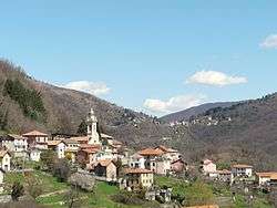
Davagna is a comune (municipality) in the Province of Genoa in the Italian region Liguria, located about 13 kilometres (8 mi) northeast of Genoa. As of 31 December 2004, it had a population of 1,817 and an area of 22.1 square kilometres (8.5 sq mi).[1]
Geography
The municipality of Davagna borders the following municipalities: Bargagli, Genoa, Lumarzo, Montoggio and Torriglia. It contains the frazioni (subdivisions, mainly villages and hamlets) of Canate, Capenardo, Cavassolo, Calvari, La Presa, Maggiolo, Marsiglia, Meco, Moranego, Paravagna, Piancarnese, Pie' di Rosso, Rosso, Scoffera, Sella, Sottana, Sottocolle and Villamezzana.
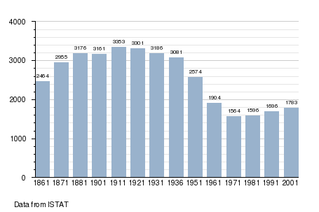
Demographics
References
External links
![]() Media related to Davagna at Wikimedia Commons
Media related to Davagna at Wikimedia Commons
- (Italian) Davagna official website
This article is issued from Wikipedia - version of the 3/15/2014. The text is available under the Creative Commons Attribution/Share Alike but additional terms may apply for the media files.