Dawesville Channel
Coordinates: 32°36′19″S 115°38′24″E / 32.60528°S 115.64000°E

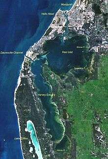
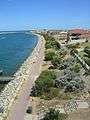
Dawesville Channel (also known as Dawesville Cut) is a man-made channel between the Peel-Harvey Estuary and the Indian Ocean at Dawesville about 80 km south of Perth in Western Australia. It is just south of the regional city of Mandurah and just north of Yalgorup National Park.
The channel was constructed to alleviate an environmental problem which had developed where much of the 136 km², two metre deep estuarine system had become eutrophic. The adjoining estuaries' ability to support the natural flora and fauna had become seriously degraded and the smell of rotting algae, particularly during the summer months had caused increasing complaints from residents. Stocks of the normally abundant fish and crabs had become depleted and recreational use was impacted. The deteriorating environmental situation became a major political and environmental issue for the Government of Western Australia during the mid-1980s.[1]
The channel allows seawater from the Indian Ocean to regularly flush in and out of the estuary using the daily tidal movements which in turn prevent the buildup of algae.
Background
Between May and October of each year, about 1000 mm of rain fall into the catchment areas of the Murray, Serpentine and Harvey Rivers and their tributaries. This represents almost all of the annual rainfall, and so in the drier summer months the rainfall is all but non-existent. This is due to the region's Mediterranean climate.
The first European settlers had found the area almost impassable for many months of the year as the flatlands above the estuary become vast floodplains. During the late 1800s, landowners and governments started constructing major drainage systems and culverts to remove the excess water to free up grazing land for livestock and pastures. Forested areas were also cleared. Since then, over 100 years of development of the low-lying sandplain depleted the moisture holding capacity of the soil and any rainfall that fell in the region quickly dissipated into the drains. Soil quality became increasingly degraded and farmers reverted to excessive superphosphate use to compensate for the loss of nutrients.
In the early 1970s, several industries, including a large piggery and sheep holding paddocks within the lower catchment poured quantities of nutrients into the river system.
A tipping point occurred during the 1970s and 1980s when the discharge of nutrients into the estuary resulted in it becoming eutrophic. Growths of macroalgae in the form of toxic cyanobacteria nodularia spumigena started occurring on a regular seasonal basis. The combination of sunlight and stagnant, nutrient rich, heated water caused massive blooms of blue-green algae.
In the meantime, the region surrounding the estuaries, particularly the coastal strip south of Mandurah was undergoing a major population growth.
Attempts at resolving the algae problem
For over twenty years, government and agricultural industry groups battled with the issue, largely unsuccessfully. The scale of the problems seemed daunting and because there seemed to be numerous causes, and most stakeholders blamed each other. As a result, the problem got worse and the issue became politicised.
Some programs that were undertaken with various degrees of success included:
- development of a "sandplain" superphosphate by CSBP which retained its nutrients for much longer
- large-scale top-dressing of farm land with bauxite tailings taken from ALCOA's mines
- replanting cleared land
- refurbishment of waterland fauna habitats (using Work for the Dole labour)
- removal of some of the large scale industries including the piggery
- educating farmers on better farming practice, including restrictions placed on use of phosphate-laden fertilisers.
- harvesting of algae on the estuary foreshores (using graders) and trucking the collected material off-site. Other automated mechanical harvesting systems were also tried.
A solution
The solution was proposed after a number of studies including those of environmental scientists Professor Arthur McComb[2] and Ernest Hodgkin who identified that the cause of the blooms were the phosphorus load in the water which had come from run-off associated with agricultural and industrial practices in the catchment area. They formed the conclusion that altered procedures for applying fertiliser would improve the estuary, but that a dramatic improvement in the short-term would only be achieved by cutting a new channel to the ocean.[3]
The proposed channel would increase water exchange between the estuary and the ocean to facilitate the flushing of nutrients from the estuary out to sea, and would increase the salinity to levels that would restrict germination and growth of the blue-green algae. A daily tidal movement of about 1 metre assisted the flushing process.
The solution also included widening and deepening of the natural estuary opening into the sea near the Mandurah township.
Construction
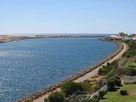
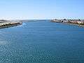
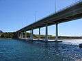
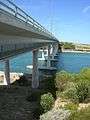
After several years of deliberations, a decision was made to build the channel at an estimated cost of $37 million. The channel's construction commenced in 1990 and was completed in April 1994. It is about 2.5 kilometres long, 200 metres wide and between 6 and 6.5 metres deep.[4] Construction involved the excavation of about 4.5 million cubic metres of material.[5] In addition to the excavation work, construction of breakwaters, training walls, a bridge and installation of a sand bypassing system was undertaken.
The channel is spanned by the four lane Port Bouvard Bridge which forms part of the Old Coast Road which carries traffic between Perth and the southern coastal townships. Approximately 40,000 vehicles per day use the road. Major residential canal developments have been constructed off the channel including the suburb of Wannanup and a golf course.
Since its opening in 1994 no blue-green algal blooms have occurred.
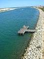
Sand bypassing
As part of the construction, a sand trap immediately to the south of the sea opening was incorporated into the design to capture sand buildup from the natural south to north movement along the coast caused by the predominant south-westerly winds. If the sand was not captured and mechanically moved, the channel would quickly close as there is insufficient water flow out of the channel to compensate for the buildup.
Approximately 85,000 m³ of sand per year is mechanically moved from the south to the northern side of the channel. This is done by converting the buildup in the catchment area into a slurry and pumping the mixture across the channel in one of two submerged 315 mm pipes.[4]
Gallery
References
- ↑ Bradby, Keith (1997). Peel-Harvey : The Decline and Rescue of an Ecosystem. Greening the Catchment Taskforce, Mandurah. ISBN 0730980413.
- ↑ "Professor Arthur McComb, 2002 AMSA Silver Jubilee Award Winner". Australian Marine Sciences Association. 2002-07-19. Retrieved 2006-12-12.
- ↑ Hodgkin, E.P., Birch, P.B., Black, R.E. & Humphries, R.B. 1981, The Peel-Harvey Estuarine System Study (1976-80), Report no. 9, Department of Conservation and Environment, Perth.
- 1 2 Charlie Bicknell. "Review of Sand Bypassing at Dawesville and Mandurah, July 2006" (PDF). Department of Planning and Infrastructure. Retrieved 2006-12-03.
- ↑ Brodie, John: The problems of nutrients and eutrophication in the Australian marine environment