Delaware Route 5
| ||||
|---|---|---|---|---|
 | ||||
| Route information | ||||
| Maintained by DelDOT | ||||
| Length: | 19.48 mi[1] (31.35 km) | |||
| Existed: | 1938[2] – present | |||
| Major junctions | ||||
| South end: | River Road in Oak Orchard | |||
|
| ||||
| North end: |
| |||
| Location | ||||
| Counties: | Sussex | |||
| Highway system | ||||
| ||||

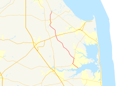
Delaware Route 5 (DE 5) is a 19.48-mile-long (31.35 km) state highway in Sussex County, Delaware. The route runs north from River Road on the Indian River Bay in Oak Orchard north to DE 1, north of Milton. Along the way, DE 5 passes through rural areas along with the communities of Long Neck, Harbeson, and Milton. The route has concurrencies with DE 23 and DE 24 in the Long Neck area. DE 5 features one alternate route, DE 5 Alternate (DE 5 Alt.), which provides a bypass of Milton. DE 5 was built as a state highway in the 1920s and 1930s, receiving its designation by 1938. DE 5 Alt. was designated by 2001.
Route description

DE 5 heads northwest on two-lane undivided Oak Orchard Road from the intersection with River Road on the shore of the Indian River Bay, passing through the residential areas of Oak Orchard. The road continues through a mix of farms and woods with some housing developments, coming to an intersection with DE 24. At this point, DE 5 turns northeast to form a concurrency with DE 24 on John J. Williams Highway. The road heads north through residential and commercial development with some fields as it enters the Long Neck area, where it intersects DE 23.[3][4]
At the DE 23 intersection, DE 5 splits from DE 24 and turns northwest onto DE 23, which is called Indian Mission Road. The road heads through a mix of farmland and woodland with some housing subdivisions. In Fairmount, DE 23 branches off to the northeast, and DE 5 continues to the northwest through more rural areas. At the intersection with DE 24 Alt. in Hollyville, the name changes to Harbeson Road. The route turns north and reaches Harbeson. In Harbeson, DE 5 crosses a Delaware Coast Line Railroad line and intersects US 9/DE 404 near Beaverdam Cemetery.[3][4]
Past this intersection, the road runs north through more rural land before curving northwest. The route turns north again and comes to an intersection with the southern terminus of the DE 5 Alt. bypass to the west of Milton, which heads west on Sand Hill Road. Also at this intersection, the name changes from Harbeson Road to Federal Street. DE 5 continues northeast into Milton, encountering the Milton Rail-Trail and passing several homes. At the intersection with Front Street, the route turns northwest onto Union Street, running through the downtown and crossing the Broadkill River. The road continues through residential areas in the northern part of Milton. At the north end of town, DE 5 intersects DE 16 along with the northern terminus of DE 5 Alt., which heads west on DE 16. DE 5 continues north on Union Street Extended, passing through agricultural areas with some woods and homes. The route turns northeast and comes to its northern terminus at DE 1.[3][4]
DE 5 has an annual average daily traffic count ranging from a high of 18,803 vehicles at the intersection with DE 23 and DE 24 to a low of 2,170 vehicles at south end of the DE 24 concurrency.[1] None of DE 5 is part of the National Highway System.[5]
History
By 1920, what is now DE 5 existed as an unimproved county road.[6] The road was upgraded to a state highway between Harbeson and Milton by 1924.[7] The following year, the road was proposed as a state highway north of Milton and from Oak Orchard to the present-day north end of the DE 24 concurrency.[8] The entire length of the present DE 5 was completed as a state highway by 1931.[9] DE 5 was assigned to its current alignment by 1938, running between Oak Orchard and DE 14 (now DE 1) north of Milton.[2] By 1994, DE 23 was designated to run concurrent with a portion of DE 5 in the Long Neck area.[10]
Major intersections
The entire route is in Sussex County.
| Location | mi[1] | km | Destinations | Notes | |
|---|---|---|---|---|---|
| Oak Orchard | 0.00 | 0.00 | River Road | ||
| 1.99 | 3.20 | South end of DE 24 overlap | |||
| Long Neck | 3.56 | 5.73 | North end of DE 24 overlap, south end of DE 23 overlap | ||
| North end of DE 23 overlap | |||||
| Hollyville | 6.98 | 11.23 | |||
| Harbeson | 11.80 | 18.99 | |||
| Milton | |||||
| 17.01 | 27.37 | ||||
| 19.48 | 31.35 | ||||
1.000 mi = 1.609 km; 1.000 km = 0.621 mi
| |||||
Bannered routes
| |
|---|---|
| Location: | Milton |
| Length: | 3.8 mi[11] (6.1 km) |
| Existed: | 2001[12]–present |
Delaware Route 5 Alternate (DE 5 Alt.) is a 3.8-mile-long (6.1 km) alternate route of DE 5 that bypasses the town of Milton. The route travels west from DE 5 south of Milton along two-lane undivided Sand Hill Road through areas of farms and woods with some homes. The route turns north to join DE 30 on Gravel Hill Road, crossing an abandoned railroad line just east of the terminus of a Delaware Coast Line Railroad branch. DE 5 Alt. splits from DE 30 by turning east onto DE 16, following that route through more rural areas on Beach Highway. The route ends at an intersection with DE 5 north of Milton. In some locations, the route is signed as "DE 5 Truck Alt".[3][11] The route was designated by 2001.[12]
- Major intersections
The entire route is in Milton, Sussex County.
| mi[11] | km | Destinations | Notes | ||
|---|---|---|---|---|---|
| 0.0 | 0.0 | Southern terminus | |||
| 1.3 | 2.1 | South end of DE 30 overlap | |||
| 2.4 | 3.9 | North end of DE 30 overlap, south end of DE 16 overlap | |||
| 3.8 | 6.1 | Northern terminus | |||
1.000 mi = 1.609 km; 1.000 km = 0.621 mi
| |||||
See also
 U.S. Roads portal
 Delaware portal
References
- 1 2 3 Staff (2011). "Traffic Count and Mileage Report: Interstate, Delaware, and US Routes" (PDF). Delaware Department of Transportation. Retrieved May 17, 2012.
- 1 2 Delaware State Highway Department; The National Survey Co. (1938). Official Road Map of the State of Delaware (PDF) (Map). Dover: Delaware State Highway Department. Retrieved November 24, 2015.
- 1 2 3 4 Delaware Department of Transportation (2008). Delaware Official Transportation Map (PDF) (Map). Dover: Delaware Department of Transportation. Retrieved November 24, 2015.
- 1 2 3 Google (August 24, 2010). "overview of Delaware Route 5" (Map). Google Maps. Google. Retrieved August 24, 2010.
- ↑ National Highway System: Delaware (PDF) (Map). Federal Highway Administration. 2010. Retrieved February 10, 2012.
- ↑ Delaware State Highway Department (1920). Official Road Map (PDF) (Map). Dover: Delaware State Highway Department. Retrieved November 24, 2015.
- ↑ Delaware State Highway Department (1924). Official Road Map (PDF) (Map). Dover: Delaware State Highway Department. Retrieved November 24, 2015.
- ↑ Delaware State Highway Department (1925). Official Road Map (PDF) (Map). Dover: Delaware State Highway Department. Retrieved November 24, 2015.
- ↑ Delaware State Highway Department (1931). Official Road Map of the State of Delaware (PDF) (Map). Dover: Delaware State Highway Department. Retrieved November 24, 2015.
- ↑ Delaware Department of Transportation; Division of Planning Cartographic Information Section (1994). Delaware Official State Map (PDF) (Map). Dover: Delaware Department of Transportation. Retrieved November 24, 2015.
- 1 2 3 Google (August 24, 2010). "overview of Delaware Route 5 Alternate" (Map). Google Maps. Google. Retrieved August 24, 2010.
- 1 2 Delaware Department of Transportation (2001). Delaware Official Transportation Map (PDF) (Map). Dover: Delaware Department of Transportation. Retrieved November 24, 2015.
External links