Delaware Route 4
| ||||
|---|---|---|---|---|
 | ||||
| Route information | ||||
| Maintained by DelDOT | ||||
| Length: | 14.08 mi[1] (22.66 km) | |||
| Existed: | 1967[2] – present | |||
| Major junctions | ||||
| West end: |
| |||
|
| ||||
| East end: |
| |||
| Location | ||||
| Counties: | New Castle | |||
| Highway system | ||||
| ||||

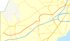
Delaware Route 4 (DE 4) is a state highway in New Castle County, Delaware. The route runs from DE 279 and DE 896 in Newark east to DE 48 in downtown Wilmington. The route passes through suburban areas in northern New Castle County between Newark and Wilmington, intersecting DE 72 in the eastern part of Newark, DE 273 in Ogletown, DE 58 in Christiana, DE 7 in Stanton, DE 141 in Newport, DE 62 and DE 100 between Newport and Wilmington, and Interstate 95 (I-95)/U.S. Route 202 (US 202) in Wilmington. DE 4 is a four-lane road much of its length.
What is now DE 4 was originally a county road that was paved in the 1930s. DE 4 was designated in the 1960s to run from the Maryland border along Chestnut Hill Road near Newark east to DE 48 in Wilmington. Between 1971 and 1981, the route extended past DE 48 along Washington Street and Washington Street Extension to US 13 Business (US 13 Bus.) in Bellefonte. In the 1980s, the western terminus of DE 4 was realigned from Chestnut Hill Road to the newly built Christiana Parkway, terminating at DE 2 (now DE 279) and DE 896.
Route description

DE 4 begins at an intersection with Elkton Road in Newark, which heads southwest as DE 279 and northeast as DE 896. From here the route heads southeast concurrent with DE 896 on the three-lane undivided Christiana Parkway, carrying two eastbound lanes and one westbound lane. The road runs through wooded areas and comes to a bridge over Amtrak's Northeast Corridor railroad line before it cures east and widens into a four-lane divided highway as it passes to the south of the University of Delaware's Science, Technology, and Advanced Research campus.[3][4]
At the intersection with South College Avenue DE 896 splits to the south and DE 4 continues east near Delaware Stadium and the Bob Carpenter Center on the University of Delaware campus to the north, intersecting Chestnut Hill Road. At this point the road becomes Chestnut Hill Road and runs between farmland to the north and residential neighborhoods to the south as it comes to a crossing of Norfolk Southern's Delmarva Secondary railroad line. The road heads into commercial areas and intersects DE 72.[3][4]
Past this intersection, DE 4 continues east along Chestnut Hill Road and heads into suburban Brookside, passing through residential neighborhoods with some businesses and curving to the northeast. The route continues to Ogletown and passes to the southeast of the Delaware School for the Deaf before it has an interchange with DE 273 and the name changes to Ogletown Stanton Road. Following this, the road passes to the north of Christiana Hospital. Beyond the hospital DE 4 comes to an intersection with the western terminus of DE 58 and an access road to Delaware Park Racetrack and the Churchmans Crossing station on SEPTA's Wilmington/Newark Line (which follows the Northeast Corridor) in Christiana. The route continues through commercial areas with some woods and curves east to reach an intersection with DE 7.[3][4]
At this point, DE 4 turns north for a concurrency with DE 7 on the six-lane divided Stanton Christiana Road, running through wooded areas with nearby development, including the Hale-Byrnes House, and passing over Amtrak's Northeast Corridor railroad line and White Clay Creek. The road passes to the east of Delaware Park Racetrack and curves northeast into Stanton. At this point, the two routes head into a commercial area and split into the one-way pair of Mitch Road eastbound and Main Street westbound. DE 7 splits from DE 4 by heading northwest on Limestone Road. DE 4 continues east along the one-way pair past homes and businesses with two lanes in each direction, crossing Red Clay Creek. The directions of the route rejoin and the route becomes four-lane divided West Newport Pike. DE 4 enters Newport and splits into the one-way pair of West Market Street eastbound and West Justis Street westbound. The route interchanges with the DE 141 and the one-way pair becomes East Market Street eastbound and East Justis Street westbound.[3][4]
The two directions of DE 4 rejoin and the route continues northeast as four-lane undivided East Newport Pike.The road leaves Newport and heads between suburban neighborhoods to the northwest and Banning Park to the southeast. The route intersects DE 62 and becomes Maryland Avenue, passing a mix of homes and businesses. The road comes to an intersection with the southern terminus of DE 100 and crosses a CSX railroad line. DE 4 continues into Wilmington and passes rowhomes and businesses. The route passes under I-95/US 202 and comes to a ramp from northbound I-95/US 202. Past this, DE 4 enters downtown Wilmington and splits into the one-way pair of Maryland Avenue eastbound and South Monroe Street westbound before ending at DE 48, which is routed on the one-way pair of Martin Luther King, Jr. Boulevard eastbound and West Second Street westbound.[3][4]
DE 4 has an annual average daily traffic count ranging from a high of 53,936 vehicles at the west end of the DE 7 concurrency to a low of 12,033 vehicles at the I-95/US 202 interchange.[1] The entire length of DE 4 is part of the National Highway System.[5]
History
By 1920, what would become DE 4 existed as a county road.[6] The road from Stanton to Wilmington was paved four years later[7] and the portion west of Stanton was paved by 1936.[8] In 1936, work was underway to improve the road between Stanton and Newport by widening and resurfacing it, with completion a year later.[9][10] In 1957, Maryland Avenue between Silview and Boxwood Road was widened to four lanes and the one-way pair along Market Street and Justis Street in Newport was established.[11]
The present DE 4 designation first appeared in 1967, at which point it ran from the Maryland border near Newark east to DE 48 in Wilmington, following Chestnut Hill Road from the state line before picking up its current alignment southeast of Newark.[2] By 1971, the route was extended northeast to US 13 Bus. in Bellefonte, forming a brief concurrency with DE 48 before continuing along Washington Street and Washington Street Extension.[12] DE 4 was truncated back to DE 48 by 1981, with DE 3 being realigned to the easternmost part of Washington Street Extension three years later.[13][14] The portion of DE 4 concurrent with DE 7 was widened into a divided highway in 1985, with the road shifted west to a new alignment passing over the Amtrak tracks and the White Clay Creek.[15]
The Christiana Parkway around the southern edge of Newark was completed in September 1983[14][16] and DE 4 was realigned to use the Christiana Parkway by 1987, ending at DE 2 in the southwestern part of Newark.[17] DE 896 was rerouted to use the Christiana Parkway the following year with DE 2 following by 1990.[18][19] The DE 2 designation was removed from the Christiana Parkway in 2013.[20]
Major intersections
The entire route is in New Castle County.
| Location | mi[1] | km | Destinations | Notes | |
|---|---|---|---|---|---|
| Newark | 0.00 | 0.00 | Western terminus, west end of DE 896 concurrency | ||
| 1.42 | 2.29 | East end of DE 896 concurrency | |||
| 2.29 | 3.69 | ||||
| Ogletown | Interchange | ||||
| Churchmans Crossing | 6.54 | 10.53 | |||
| 7.50 | 12.07 | West end of DE 7 concurrency | |||
| Stanton | 8.66 | 13.94 | East end of DE 7 concurrency | ||
| Newport | 10.82 | 17.41 | DE 141 exit 4 | ||
| 11.87 | 19.10 | ||||
| Wilmington | 12.54 | 20.18 | |||
| 13.87 | 22.32 | Ramp from northbound I-95/US 202, I-95/US 202 exit 6 | |||
| 14.08 | 22.66 | Eastern terminus, access to Wilmington Station | |||
1.000 mi = 1.609 km; 1.000 km = 0.621 mi
| |||||
See also
 U.S. Roads portal
 Delaware portal
References
- 1 2 3 Staff (2011). "Traffic Count and Mileage Report: Interstate, Delaware, and US Routes" (PDF). Delaware Department of Transportation. Retrieved May 17, 2012.
- 1 2 Delaware State Highway Department (1967). Official Highway Map (PDF) (Map). Dover: Delaware State Highway Department. Retrieved November 24, 2015.
- 1 2 3 4 5 Delaware Department of Transportation (2008). Delaware Official Transportation Map (PDF) (Map). Dover: Delaware Department of Transportation. Retrieved November 24, 2015.
- 1 2 3 4 5 Google (February 6, 2011). "overview of Delaware Route 4" (Map). Google Maps. Google. Retrieved February 6, 2011.
- ↑ National Highway System: Delaware (PDF) (Map). Federal Highway Administration. 2010. Retrieved February 10, 2012.
- ↑ Delaware State Highway Department (1920). Official Road Map (PDF) (Map). Dover: Delaware State Highway Department. Retrieved November 24, 2015.
- ↑ Delaware State Highway Department (1924). Official Road Map (PDF) (Map). Dover: Delaware State Highway Department. Retrieved November 24, 2015.
- ↑ Delaware State Highway Department; The National Survey Co. (1936). Official Road Map of the State of Delaware (PDF) (Map) (1936–37 ed.). Dover: Delaware State Highway Department. Retrieved November 24, 2015.
- ↑ "Annual Report of the State Highway Department" (PDF) (1936 ed.). Dover, Delaware: Delaware State Highway Department. January 20, 1937: 20. Retrieved November 13, 2014.
- ↑ "Annual Report of the State Highway Department" (PDF) (1937 ed.). Dover, Delaware: Delaware State Highway Department. January 1, 1938: 17. Retrieved November 13, 2014.
- ↑ "Report of the State Highway Department" (PDF) (1957 ed.). Dover, Delaware: Delaware State Highway Department. July 1, 1957: 16. Retrieved November 13, 2014.
- ↑ Delaware Department of Highways and Transportation (1971). Delaware Highways Official Map (PDF) (Map). Dover: Delaware Department of Highways and Transportation. Retrieved November 24, 2015.
- ↑ Delaware Department of Transportation (1981). Delaware Official State Highway Map (PDF) (Map). Dover: Delaware Department of Transportation. Retrieved November 24, 2015.
- 1 2 Delaware Department of Transportation (1984). Official State Highway Map (PDF) (Map). Dover: Delaware Department of Transportation. Retrieved November 24, 2015.
- ↑ Delaware Department of Transportation (1985). Official State Highway Map (PDF) (Map). Dover: Delaware Department of Transportation. Retrieved November 24, 2015.
- ↑ "Newark council says truckers evade tolls". The News Journal. Wilmington, DE. November 15, 1983.
- ↑ Delaware Department of Transportation (1987). Official State Highway Map (PDF) (Map). Dover: Delaware Department of Transportation. Retrieved November 24, 2015.
- ↑ Delaware Department of Transportation (1988). Official State Highway Map (PDF) (Map). Dover: Delaware Department of Transportation. Retrieved November 24, 2015.
- ↑ Delaware Department of Transportation (1990). Official State Map (PDF) (Map). Dover: Delaware Department of Transportation. Retrieved November 24, 2015.
- ↑ Shannon, Josh (July 1, 2013). "A route to less clutter: DelDOT to consolidate Newark route numbers". Newark Post. Retrieved August 15, 2013.
External links
 Media related to Delaware Route 4 at Wikimedia Commons