Dharchula
| Dharchula धारचूला | |
|---|---|
| city | |
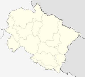 Dharchula  Dharchula Location in Uttarakhand, India also Nepal | |
| Coordinates: 29°50′54.6″N 80°32′34.8″E / 29.848500°N 80.543000°ECoordinates: 29°50′54.6″N 80°32′34.8″E / 29.848500°N 80.543000°E | |
| Country |
|
| State | Uttarakhand |
| District | Pithoragarh |
| Population (2001) | |
| • Total | 6,424 |
| Languages | |
| • Official | Hindi |
| Time zone | IST (UTC+5:30) |
| Vehicle registration | UK |
| Website |
uk |
Dharchula (Hindi: धारचूला) is a town and a nagar panchayat in Pithoragarh district in the northern state of Uttarakhand, India. Dharchula is an ancient trading town for the trans-Himalayan trade routes. It is surrounded by high mountains and is situated in a valley, on the banks of the Kali River at 915 m (3,002 ft) elevation.
Dharchula lies about 83 km (52 mi) northerly of Pithoragarh along the route of the Kailash-Mansarovar pilgrimage tour. The name of the town may originate from the Hindi words for "mountain peak" (dhar) and "stove" (chulha) because the valley in which it lies resembles a stove.
Dharchula is cold during winters, but it usually does not get snow. Summer temperature is pleasant.
Nepal has a town with a similar name, Darchula, across the river Mahakali - which acts as the natural border between India and Nepal over a long stretch. People of both towns have similar traditions, culture, and lifestyle and move across the border without hindrance and without passport or visa. The area has a mixture of Kumaouni and Tibetean language, traditions and culture.
Demographics
As per the 2011 census,[1] Dharchula Nagar Palika has population of 7,039 of which 3,797 are males while 3,242 are females. Population of Children with age of 0-6 is 890 which is 12.64% of total population of Dharchula (NP). Female Sex Ratio is of 854 against state average of 963. Child Sex Ratio in Dharchula is around 824 compared to Uttarakhand state average of 890. Literacy rate of Dharchula city is 88.68% higher than state average of 78.82%. In Dharchula, Male literacy is around 95.10% while female literacy rate is 81.20%.
Dharchula Nagar Palika has total administration over 1,712 houses to which it supplies basic amenities like water and sewerage. It is also authorized to build roads within Nagar Palika limits and impose taxes on properties coming under its jurisdiction.
Primary religion followed is Hinduism (91.45%), followed by Islam (7.61%), Christianity (0.67%) and Sikhism (0.17%).
As per the 2001 census[2] Dharchula had a population of 6424. Males constituted 54% of the population and females, 46%. Dharchula had an average literacy rate of 75%, higher than the national average of 59.5%. Male literacy was 80% and female literacy was 69%. In Dharchula, 12% of the population was under 6 years of age.
Dharchula is mainly inhabited by the Rung tribe known for its dynamism, resilience and culturally rootedness.It has its own unique culture and the members of this tribe feel proud of their rich heritage. Rung Kalyan Sanstha is an institution which binds together the entire Rung community. Dharchula has the Rung Community School.
Geography
The town is situated in a beautiful valley at 915 m elevation and is 83 km from its district headquarters, Pithoragarh. The way from Pithoragarh to Dharchula is alongside the Kali River and is a 3 to 3.5 hour journey. The chief modes of transportation available are private jeeps and state government buses. However, reaching Pithoragarh itself from the plains is a tiring journey. One can reach Pithoragarh from either Haldwani or from Tanakpur (both towns situated on the foothills of Himalayas in the Uttarakhand district).
Haldwani is a city near Bareilly (in UP). From Haldwani, one can take either private jeeps or state government buses. The journey to Pithoragarh is of around 8 hours. Generally the private jeeps and buses run from Haldwani only till around 11 a.m. as it's quite dangerous to drive at night in the hilly tracks. The road is quite good and there are quite a many good Dhabas (small restaurants) midway. However, the landslides in the rainy season (July–September) make the travel a bit dangerous and inconvenient.
Tanakpur can be reached from Lucknow or Bareilly by an overnight train journey, the modes of transportation from Tanakpur to Pithoragarh being same as from Haldwani to Pithoragarh. However, the distance from Tanakpur to Pithoragarh is shorter and takes approximately 6 hours. Although the roads towards this side of the hills have more curves and can create nausea, the journey to the town provides the travelers the magnificent sightseeing opportunity of the grand Himalayan peaks.
Dharchula has a KMVN (Kumaon Mandal Vikas Nigam) rest house. Dharchula is the base camp for the Kailash Manasarover Yatra and Aadi Kailash Yatra. Situated on the bank of the river Kali, Dharchula has the unique distinction of having a marine drive along the Kalli river.
History
History of Pithoragarh, Dharchula is related with Katyuri Dynasty.
Climate
Summers are warm and shiny, whereas the winters are cold. The higher altitude regions of Dharchula (basically upper valleys) receives snow during the winter season (December to February end). The area also receives heavy rainfall during the rainy season (July–September) which disrupts the normal course of life of the people and often causes landslides in the mountain areas. The entire town looks beautiful during winters with snow-capped hills all around and you are in the middle of the valley. As the sun rises the snow starts melting and there are streams flowing down towards the river. These streams are all around and have a fixed path every year. Though exact record of when did it snow in the past is not known but in the year 2006 it snowed in the town and the entire town was under the cover of snow. It is said that it had snowed around 50 years back but there are no such pictures though. There is a warm water spring called "doom pani" which are clearly demarked for men and women. The woman folk go and wash their clothes there. There is also a very hot water spring at a place called Tapovan. During Shiv Ratri, people go to Tapovan and take a bath by mixing the hot water with the cold water from the river. It is a sulphur spring and known to be good for the skin.
People
The town is dominated by and Rung and Shauka people, the two words often being used as synonyms. They have sharp features and are of short height. The people are quite hospitable and simple in their living. These people have been living in the surrounding mountains of Dharchula valley since ages. In early times, people used to live in surrounding hills during the summer season and hibernate to the green valley of Dharchula in winters to beat the extremely cold weather at the high altitudes. Gradually the people started getting used to live in the relatively warmer climate of the valley and that's how the place became a permanent ground for the people once hibernating there. Tents and wooden houses soon changed into houses of brick and mortar. What started as a small stop over place in the early 1900s had developed to a full grown town by the 1990s.
The town not only provides a permanent shelter to the regional people, but also a resting place to traders and pilgrims who cross the town in order to reach their destinations far ahead. This growing crowd was a start of the trend which lay the foundation of Dharchula's commercialization. With passing time, people from different parts of the plains and foothill areas started settling in Dharchula to tap the commercial opportunities of the area. Although the majority of the population in Dharchula still consists of Rung people, there are lot other sects of people too, like Punjabis, Baniyas, etc.
Lifeline of the people
In earlier times, the entire population was dependent on trade with the Tibetans. Goods from India like handmade carpets (better known as 'Dan' locally) and spices were traded in exchange for clothes, eatables, etc. Soon after the Indo-Sino war of 1962, all trade relations with Tibet were snapped. The war broke the lifeline of the place - trade, the only means of earning for the Dharchula residents. This difficult time forced the people to look for alternate means of earnings. Soon the local population engaged themselves in farming (terrace farming), small businesses and cattle farming. Catering to the tourism requirements is still an unexploited opportunity the youth population is looking forward to fulfill. However, it is only after the government's intervention and help that good tourism facilities can develop in the town and surrounding areas, thus creating an employment opportunity for many. Today, after the increased awareness about the job opportunities available beyond Dharchula and the surrounding hilly towns, the local people are venturing into government jobs and businesses all over the country, and also overseas.
Very recently, a new earning opportunity has been found in the form of a fungus, colloquially known as caterpillar fungus. The fungus is known in Tibetan as yarsa gambu or yatsa gunbu. Caterpillar fungi are the result of a parasitic relationship between the fungus and the larva of the ghost moth genus Thitarodes, several species of which live on the Himalayas in India and Nepal. The fungus germinates in living organisms, kills and mummifies the insect, and then the fungus grows from the body of the insect.
The hand-collected fungus-caterpillar combination is valued by herbalists and as a status symbol. It is used as an aphrodisiac and treatment for ailments such as fatigue and cancer, although such use is mainly based on traditional Chinese medicine, anecdote, and a limited amount of research. Clinical trials have not established its efficacy.
The fungus was known as Cordyceps sinensis until 2007, when molecular analysis was used to amend the classification of the Cordycipitaceae and the Clavicipitaceae, resulting in the naming of a new family – Ophiocordycipitaceae – and the transfer of several Cordyceps species to Ophiocordyceps. Though it has not been legalised, this caterpillar harvesting has provided earning opportunities to many youth. During the harvesting season, manual labourers are hard to find because they all move to the hills along with their families and camp at the site for several days. Selling it is not difficult – there are buyers who even come from across the border to buy it.
Language and culture
The Rungs communicate among themselves in the local language RungLo. The language still continues to exist despite the fact that it has no written script. It's probably one of the few languages that continues to thrive without a written script. However, analyzing the fact that nowadays most of the youth of the town are looking for employment opportunities in the outside world and thus using less of RungLo, the day is not far when RungLo too will fall in the category of moribund languages. Apart than RungLo, the local population is quite well versed in Hindi, Nepali and English.
The Rungs celebrate all of their festivals and important occasions with great zeal and enthusiasm. The celebrations are marked with the presence of dance, baira(songs) and sathani (a locally prepared wine).
Like most other ethnic groups, Rungs also have their traditional wear, which is addressed as Chungbala and Ranga. Byanthalo (the turban) is also a part of the men's wear. Big silver necklaces, nose and ear rings constitute the jewellery of women here. The use of the traditional wear is nowadays restricted to only important occasions and big celebrations. More about it can be found out at their site www.rungmung.net/NauksumV4. However, it is far from reality to simply assume that the people here are not fashion aware due to the geographical isolation. Everything from Ghagras to Lehngas and Levis Jeans to torn jeans can be seen in the streets here, thanks to the growing commercialization and the small Moti Bazaar (market) of Nepal.
The Rungs worship their local Deities Syangse and Gabla, the different forms of Hindu Gods.
Dharchula will soon have a well-stocked community library. A small sports stadium is already functional. The pride of Dharchula is going to be the Rung Cultural Museum which will house the living cultural symbols of this extremely proud and culturally vibrant community.
Flora and Fauna
The climatic conditions and the low human interference till date has allowed the green vegetation of this region to thrive. Trees of Oak, Pine, Apple and Deodar can be easily seen here. apart from that, several trees of dry fruits can also be spotted. However, with the increasing global warming, the trees here are now bearing lesser and lesser of fruits year after year.
Wild animals like leopard, bear, fox, monkeys and deers are found in this region. Apart from these, domestic animals like horses, mules and sheep are also found here.
Important places, landmarks and events
Following places, geographic entities and events are worth a brief mention:
Narayan Ashram: Narayan Ashram[3] is situated at an elevation of 2734 m. above sea level. It can be reached from Pithoragarh via Ogla(44 km from Pithoragarh), Jauljibi(77 km), Dharchula(94 km), Tawaghat (108 km). Jauljibi is the place where Dhauliganga and Kaliganga meet.
The ashram was established by Sri Narayan Swami in 1936. It can accommodate maximum 40 persons at a time. During winter season the ashram remains closed due to heavy snowfall. And rainy season may cause damage to the road. Ashram keeps on conducting various social - spiritual activities for the members so the visitors are strictly advised to convey about their plan to the ashram well in advance.

Kailash Mansarovar: Manasarovar Lake lies at 4,590 m above mean sea level. The lake freezes in winter and melts only in the spring. The Sutlej River, the (Brahmaputra River), the Indus River, and the Karnali River all trace their sources to its close vicinity.
Like Mount Kailash, Lake Mansarovar is a place of pilgrimage, attracting religious people from India, Tibet and the neighboring countries. Bathing in the Manasa Sarovar and drinking its water is believed to cleanse all sins. Pilgrimage tours are organized regularly, especially from India, the most famous of which is the Kailash Mansarovar Yatra which takes place every year. Pilgrims come to take ceremonial bathes in the cleansing waters of the lake.
Kali River: The Kali River originates from the Greater Himalayas at Kalapaani at an altitude of 3,600 m, in the Pithoragarh District of Uttarakhand, India. The river is named after the Goddess Kali whose temple is situated in Kalapaani near the Lipu-Lekh pass at the border between India and Tibet. On its upper course, this river forms India's continuous eastern boundary with Nepal.
Chirkila Dam:[4] Uttarakhand is a land of rivers and mountains and thus holds a lot of potential for hydro electric power generation. A similar such initiative has resulted in the creation of the Chirkila dam on river Kali at Chirkila, a place 20 km ahead of Dharchula. The dam has a capacity of producing 1500 kW of energy. The dam is adjoined by a beautiful lake stretching up to 1 km in length. If news are to be believed, water sports may soon be started in the area by the Uttrakhand Government.
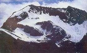
( Adi Kailash or Little Kailash or Jonglingkong Peak or Baba Kailash or Chhota Kailash is an ancient holy Hindu mountain in the Himalayan mountain range, lying in the Tehsil Dharchula, Pithoragarh district of Uttarakhand, India, near Sinla pass. Its appearance is distinctly similar to Mount Kailash in Tibet. The 'Om Parvat' is closer to the Lipulekh Pass near Nabi Dangh...on the way to Tibet... its snow deposition pattern gives the impression of the Hindu sacred syllable 'AUM' (ॐ) written on it. This majestic letter ॐ clearly stands out when the snow starts melting at the end of the winter season. The Jonglingkong lake or the Parvati Lake, like Lake Mansarovar, are sacred to the Hindus. Just opposite to the peak of Chota Kailash or Adi Kailash, lies the mountain Parwati Mukut (Parvati's Crown).
India-Nepal and India-Sino border: The town is a sensitive area as it shares its borders with both Nepal and China. However, the area has always remained peaceful place and an excellent example of good inter-cultural ties between the nations.
Important Mountain Peaks:
Religious places of worship:
References
- ↑ http://www.census2011.co.in/data/town/800320-dharchula-uttarakhand.html
- ↑ "Census of India 2001: Data from the 2001 Census, including cities, villages and towns (Provisional)". Census Commission of India. Archived from the original on 2004-06-16. Retrieved 2008-11-01.
- ↑ Narayan Swami Ashram
- ↑ http://www.uttaranchalirrigation.com/rti_eng/informationmanual1.pdf