Dillenburg
| Dillenburg | ||
|---|---|---|
| ||
 Dillenburg | ||
Location of Dillenburg within Lahn-Dill-Kreis district 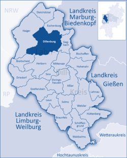 | ||
| Coordinates: 50°44′N 08°17′E / 50.733°N 8.283°ECoordinates: 50°44′N 08°17′E / 50.733°N 8.283°E | ||
| Country | Germany | |
| State | Hesse | |
| Admin. region | Gießen | |
| District | Lahn-Dill-Kreis | |
| Government | ||
| • Mayor | Michael Lotz (CDU) | |
| Area | ||
| • Total | 83.88 km2 (32.39 sq mi) | |
| Population (2015-12-31)[1] | ||
| • Total | 23,510 | |
| • Density | 280/km2 (730/sq mi) | |
| Time zone | CET/CEST (UTC+1/+2) | |
| Postal codes | 35661–35690 | |
| Dialling codes | 02771 | |
| Vehicle registration | LDK | |
| Website | www.dillenburg.de | |
Dillenburg is a town in Hesse's Gießen region in Germany. The town was formerly the seat of the old Dillkreis district, which is now part of the Lahn-Dill-Kreis.
The town lies on the German-Dutch holiday road called the Orange Route, joining towns, cities and regions associated with the House of Orange-Nassau, as well as on the German Timber-Frame Road and the Rothaarsteig hiking trail.
Geography
Location
Dillenburg lies on the eastern edge of the Westerwald range in the narrow valley of the river Dill, which flows from Hesse-Westphalia border to Wetzlar, emptying into the Lahn.
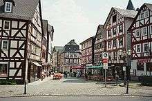

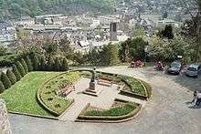
Neighbouring communities
Dillenburg borders in the north on the community of Eschenburg, in the east on the community of Siegbach, in the south on the town of Herborn, and the community of Breitscheid, and in the west on the town of Haiger (all in the Lahn-Dill-Kreis).
Constituent communities
Dillenburg is divided into the centres of Donsbach, Eibach, Frohnhausen, Manderbach, Nanzenbach, Niederscheld and Oberscheld.
Donsbach
Donsbach lies approximately 4 km southwest of the Dillenburg main town.
Eibach
Eibach has some 1,450 inhabitants.
The village, whose livelihood was once based on mining, lies among the other constituent communities of Nanzenbach, Oberscheld and Niederscheld. Its healing spring, whose water is heavy with iron, makes the village a favourite among locals. At Eastertime, it is decorated.
Frohnhausen
With roughly 3,900 inhabitants, Frohnhausen is the largest of the constituent communities after the main town of Dillenburg.
Manderbach
Manderbach lies on a sunny plateau 3 km north of the main town of Dillenburg.
Nanzenbach
Nanzenbach lies approximately 6 km north of the main town of Dillenburg. The tallest mountain of Dillenburg, the Eschenburg at an elevation of 589 m, is part of the Nanzenbach area.
Niederscheld
Niederscheld is a village with about 3000 inhabitants, lying 2 km from the main town of Dillenburg. The name comes from a small brook called the Schelde that rises between Oberscheld and Tringenstein and flows into the Dill at Niederscheld. The village's greatest hallmarks are the old blast furnace and the Adolfshütte industrial park. Towards the end of the Second World War, the village suffered comparatively heavy damage from Allied air raids. Niederscheld had been appointed a target, because parts for the V-2 rocket were built at the Adolfshütte.
Oberscheld
Oberscheld is a village with about 2000 inhabitants, it is the neighbour village from Niederscheld. The Mining was quite important for Oberscheld, there was a blast furnace, the blast furnace was closed in 1969. Oberscheld had a station, the last train ran in Oberscheld in 1987.
History
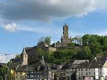
Dillenburg had its first documentary mention in 1254. Dillenburg was the ancestral seat of the Orange branch of the House of Nassau. Dillenburg Castle was built on top of the peak now called the Schlossberg in the late 13th or early 14th century. There are no pictures of this castle, however, as it was wooden, and was destroyed in the Dernbacher Feud.
From his stately home in exile, William I of Orange-Nassau, who was born in Dillenburg, organized the Dutch resistance against Spain (1567–1572), which still occasions regular Dutch royal visits to the town to this day. The land was administered by the presidents of the House of Nassau-Dillenburg. One of the last presidents was Georg Ernst Ludwig Freiherr von Preuschen von und zu Liebenstein (born 1727 in Diethardt; died 1794 in Bad Ems). In the Seven Years' War, the stately home was destroyed (1760), and Wilhelmstraße (a street) was built out of the remains.
In 1797, one of the earliest schools of forestry in Europe, founded a decade earlier at Hungen by Georg Ludwig Hartig, was moved to Dillenburg. It continued in Dillenburg until 1805, when Hartig lost his position as Inspector of Forests for the Prince of Orange-Nassau, when the principality was dissolved by Napoleon.
In 1875, the Wilhelmsturm (tower), views from which can be seen in this article, was completed on the Schlossberg. It is today the town's landmark. The "casemates" under the former stately home are among the biggest defensive works in Europe. They have been partly excavated and may be toured.
In the 19th century came the Industrial Revolution with the building of the Deutz–Gießen railway and the use of iron ore found on the Lahn, Dill and Sieg. Many mines, foundries and metalworking operations came into being in the region. In this time, many railway branchlines were built from Dillenburg to, among other places, Gönnern and Ewersbach. These lines have all been abandoned now. The line to Gönnern was abandoned in 1987 and torn up. The railway depot, so useful in the time of steam traction, was shut down in 1983.
In the Second World War, Dillenburg became a target of Allied attacks due to its marshalling yard. In later years that yard was closed and ore mining became ever less profitable and in 1968, the last blast furnace, in Oberscheld, ceased operations.
Eibach
Eibach's history began in "Nassau times" in the 13th century. In 1313, the village had its first documentary mention. In the Second World War, it was left unscathed. In 2004, the healing spring was renovated, and a brineworks was built.
Manderbach

Manderbach had its first documentary mention in 1225, making it older than the main town of Dillenburg (1254). The two former villages – nowadays parts of Dillenburg – Frohnhausen and Manderbach, had much in common in their early history. Here the two noble families von Hunsbach and von Selbach both held sway. As in Frohnhausen, there was also a great fire in Manderbach – albeit 148 years before Frohnhausen's – which, having been started by a lightning strike, burnt 38 houses down within an hour and a half on 29 April 1630.
Nanzenbach
The name Nanzenbach was mentioned for the first time in a document on 8 May 1325. This document mentions "die Nantzenbecher" — "the inhabitants of Nanzenbach".
Population development
(in each case on 31 December)
- 1998 - 25,053
- 1999 - 25,124
- 2000 - 25,092
- 2001 - 25,017
- 2002 - 24,923
- 2003 - 24,681
- 2004 - 24,533
Coat of arms
The oldest town seals, dating from the 15th to 19th centuries, show the same composition as Dillenburg's current civic coat of arms. The arms were conferred officially in 1907 and confirmed in 1934. The lion inside the gateway is the Lion of Nassau.
Culture and sightseeing
Museums
- Wilhelmsturm (tower) with the Orange-Nassau Museum
- "Villa Grün" museum of economic history
- The "Casemates", old defensive structures.
- Hessisches Landgestüt (≈ Hessian State Stud Farm) with coach museum in the Orangery. "Living Museum" about the horse.
Buildings
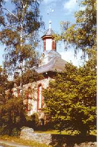
- Wilhelmsturm (tower) built in 1872 - 1875
- The "Casemates", old defensive structures.from the 16th century
- The Evangelische Town Church from 1491
- The Dillturm (tower) from 1597
- The old rectory from 1531–1533
- The Untertor (Lower Gate) from 1344 (alterations in 1594 and 1737)
- Manderbach Church
Parks
In Donsbach is a wildlife park.
Hiking trails
The following trails go through or begin in Dillenburg:
- The Rothaarsteig from Dillenburg to Brilon
- The Schlösserweg from Dillenburg to Düsseldorf -Benrath
- The Dillweg from Haiger to Wetzlar
- The Uplandweg from Dillenburg to Salzkotten
Regular events
- Jazz-Weekend, in June
- Kirschenmarkt (cherry market), in June
- Aquarena-Nacht, in July
- Hubertus-Markt, in October
- Hengstparade des Hessischen Landgestüts (stallion parade)
- Maypole Festival in Eibach, at the beginning of May
- Rocknacht music festival in Eibach, in summer.
Other
- Brineworks and healing spring, Eibach
Economy and infrastructure
Transport
The bypass on Federal Highway (Bundesstraße) B277 opened in April 2007. It is a tunnel under the Schlossberg, bypassing the historic Old Town with its timber-frame houses and it was one of Germany's biggest tunnel projects. As a result of the bankruptcy of the contractor for the works, Walter Bau, completion of the project was delayed by more than a year.
Dillenburg station is on the Dill line, part of the original Cologne-Gießen Railway. It runs from Gießen to Siegen and connects central Hesse with the Rhineland and the Ruhr. The Heller Valley Railway, runs from Betzdorf via Burbach to Dillenburg. The Dillenburg station was once a major freight terminal for iron mining in the Schelderwald.
Established businesses
- Deutsche Post AG
- E.ON Mitte (OT Oberscheld)
- Funkenerosionstechnik Hartwig Hermann
- INDEN Design
- Isabellenhütte Heusler GmbH & Co. KG
- Linde & Wiemann
- Ströher-Keramik
- ThyssenKrupp Nirosta Dillenburg Works
- TSR Recycling GmbH & Co. KG Dillenburg Branch
- Volksbank Dill eG
- Weber Kunststofftechnik
Media
- Dill-Post
- Dill-Zeitung
Public institutions
- Police station
- Fire brigade
- Dill-Kliniken (hospital)
- Deaconate
- German Red Cross Dillkreis chapter
- Lahn-Dill Youth Office
- Lahn-Dill Jugendbildungswerk
- Lebenshilfe for the mentally handicapped Kreisvereinigung für den ehem. Dillkreis e.V. (District association for the former Dill district)
- Lahn-Dill Social Office
Education
- Gewerbliche Schulen (vocational school)
- Goldbachschule (Haupt- and Realschule)
- Juliane-von-Stolberg-Schule (primary school)
- Johann-von-Nassau-Schule (Haupt- and Realschule)
- Kaufmännische Schulen (vocational school)
- Kindergartens (Evangelical, Catholic, municipal, Arbeiterwohlfahrt [German workers' welfare])
- Lahn-Dill-Akademie (Folk high school)
- Otfried-Preußler-Schule für Praktisch Bildbare (special school)
- Roteberg-Schule (primary school)
- Schelderwald-Schule (primary school and Hauptschule)
- Wilhelm-von-Oranien-Schule (Gymnasium)
Personalities
Famous natives of Dillenburg
- Otfried Hans Freiherr von Meusebach alias John O. Meusebach (1812–1897), founder of Fredericksburg, Texas and Texas Senator
- Karl Heinz Gasser, German politician
- Maria Kliegel, German cellist
- Rolf Krenzer, writer of children's books and composer
- Moritz von Nassau, Dutch field marshal, called the Brasilianer ("Brazilian")
- Ernst Casimir van Nassau-Dietz, ancestor of Kings of the Netherlands
- John VI of Nassau-Dillenburg, German aristocrat
- Maurice of Nassau (Also known as Maurits van Oranje-Nassau/Moritz von Oranien), Stadtholder of Holland, Zeeland, Utrecht, Guelders and Overijssel, also prince of Orange
- Julius Eckhardt Raht, American mining engineer and entrepreneur.
- William I of Orange-Nassau, leader in the Dutch war of independence against Spain
- Prof. Dr. Melanie Tatur, German political scientist and sociologist
- Wilhelm Zepper, reformed theologian; court chaplain and professor in Herborn
People who worked in Dillenburg
- Georg Ludwig Hartig worked from 1797 to 1805 as Inspector of Forests for the Prince of Orange-Nassau, in Dillenburg; at the same time led one of the earliest schools of forestry in Europe, also in Dillenburg
- Maximilian Mörlin Evangelical theologian and reformer
References
- ↑ "Bevölkerung der hessischen Gemeinden". Hessisches Statistisches Landesamt (in German). August 2016.
External links
| Wikimedia Commons has media related to Dillenburg. |
- Dillenburg
- Website about Dillenburg railway station and railway guide line 445
- Dillenburg fire station
- Nanzenbach
- Dillenburg at DMOZ
