Diskit
| Diskit | |
|---|---|
| village | |
|
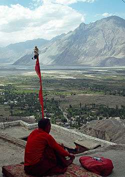
A monk meditates on terrace of Diskit Monastery, with Nubra Valley and Diskit village seen in the background | |
 Diskit  Diskit Location in Jammu and Kashmir, India | |
| Coordinates: 34°33′04″N 77°32′55″E / 34.551210°N 77.548478°ECoordinates: 34°33′04″N 77°32′55″E / 34.551210°N 77.548478°E | |
| Country | India |
| State | Jammu and Kashmir |
| District | Leh |
| Tehsil | Nubra |
| Population (2011) | |
| • Total | 1,760 |
| Time zone | IST (UTC+5:30) |
| Census code | 929 |
Diskit is a village in the Leh district of Jammu and Kashmir, India.[1] It is located in the Nubra tehsil. The Diskit Monastery is located in this village.
Demographics
According to the 2011 census of India, Diskit has 344 households. The effective literacy rate (i.e. the literacy rate of population excluding children aged 6 and below) is 76.57%.[2]
| Total | Male | Female | |
|---|---|---|---|
| Population | 1760 | 924 | 836 |
| Children aged below 6 years | 185 | 102 | 83 |
| Scheduled caste | 3 | 3 | 0 |
| Scheduled tribe | 1519 | 737 | 782 |
| Literates | 1206 | 707 | 499 |
| Workers (all) | 927 | 534 | 393 |
| Main workers (total) | 889 | 509 | 380 |
| Main workers: Cultivators | 378 | 129 | 249 |
| Main workers: Agricultural labourers | 2 | 0 | 2 |
| Main workers: Household industry workers | 0 | 0 | 0 |
| Main workers: Other | 509 | 380 | 129 |
| Marginal workers (total) | 38 | 25 | 13 |
| Marginal workers: Cultivators | 16 | 8 | 8 |
| Marginal workers: Agricultural labourers | 1 | 0 | 1 |
| Marginal workers: Household industry workers | 0 | 0 | 0 |
| Marginal workers: Others | 21 | 17 | 4 |
| Non-workers | 833 | 390 | 443 |
Tourism
Diskit is one of the major towns in Nubra region of Ladakh. It is a popular destination for tourists and is situated around 118 km from Leh and 7 km from the town of Hunder. Situated on the banks of river Shyok, Diskit has many home-stay and guest house options that are open throughout the year. The main market is a small place with a few tiny restaurants.[3]
References
| Wikimedia Commons has media related to Diskit. |
- ↑ "Blockwise Village Amenity Directory" (PDF). Ladakh Autonomous Hill Development Council. Retrieved 2015-07-23.
- 1 2 "Leh district census". 2011 Census of India. Directorate of Census Operations. Retrieved 2015-07-23.
- ↑ "Crazy Peaks".
This article is issued from Wikipedia - version of the 8/26/2016. The text is available under the Creative Commons Attribution/Share Alike but additional terms may apply for the media files.