Dogdyke
| Dogdyke | |
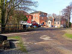 Dogdyke Marina (former railway station) |
|
 Dogdyke |
|
| OS grid reference | TF210554 |
|---|---|
| – London | 110 mi (180 km) S |
| District | North Kesteven |
| Shire county | Lincolnshire |
| Region | East Midlands |
| Country | England |
| Sovereign state | United Kingdom |
| Postcode district | LN4 |
| Police | Lincolnshire |
| Fire | Lincolnshire |
| Ambulance | East Midlands |
| EU Parliament | East Midlands |
| UK Parliament | Louth and Horncastle |
|
|
Coordinates: 53°04′58″N 0°11′39″W / 53.082705°N 0.194219°W
Dogdyke is a hamlet in the North Kesteven district of Lincolnshire, England. It is situated approximately 2 miles (3 km) south from Tattershall, and at the confluence of the Rivers Bain and Witham, and close to where the River Slea joins the Witham.[1]
Community
Dogdyke is part of the civil parish of Dogdyke with Chapel Hill[2] within the district of North Kesteven[3] and is within the ecclesiastical parish of Billinghay. The civil parish also includes nearby Tattershall Bridge, where the A153 crosses the Witham.[1] Nearby settlements are the hamlets of Chapel Hill and Tattershall Bridge, and Hawthorn Hill to which Dogdyke is conjoined.[1]
The Chapel of St Nicholas was located at Dogdyke in the 14th century, and was mentioned in 1342.[4] It has long since vanished and its location has not been found. Dogdyke appears as "Dokedyke" in the 14th century,[5] and fell within the ancient wapentake of Langoe.
The hamlet has two public houses, a caravan park and a marina.
Drainage
The first drainage pump at Dogdyke was built in 1796 and was wind-powered. It was replaced in 1856 by the Dogdyke Pumping Station which was driven by steam, and later by diesel.[6]
Dogdyke falls within the drainage area of the Witham Third District Internal Drainage Board.[7]
Chapel Hill, on the opposite west bank of the Witham, falls within the drainage area of the Witham First District Internal Drainage Board.[8]
See also
Further reading
- Marlowe, Christopher: The Fen Country, Cecil Palmer, London (1925)
References
- 1 2 3 122: Skegness & Horncastle (Map) (C2 ed.). 1:50000. OS Landranger. OSGB. 3 April 2006. ISBN 978-0-319-22939-2.
TF205550 - ↑ "Dogdyke (inc. Chapel Hill) Parish Council".
- ↑ "Parish Cluster Areas" (PDF).
- ↑ "Unlocated medieval chapel of St Nicholas at Dogdyke". Lincs to the Past. Lincolnshire Archives. Retrieved 9 May 2011.
- ↑ Maxwell Lyte, H. C., ed. (1914). Calendar of Close Rolls, Richard II. 1: 1377-1381.
- ↑ "Dog Dyke Pumping Station, Tattershall". Lincs to the Past. Lincolnshire Archives. Retrieved 9 May 2011.
- ↑ "Witham Third District IDB".
- ↑ "Witham First District IDB".
External links
 Media related to Dogdyke at Wikimedia Commons
- Media related to Tattershall Bridge at Wikimedia Commons
- "Dogdyke", Genuki.org.uk. Retrieved 7 July 2013
- "Dogdyke steam drainage station", Dogdyke.com. Retrieved 7 July 2013
England Portal | |
| Unitary authorities | |
| Boroughs or districts | |
| Major settlements |
|
| Topics | |