Donga Department
| Donga | |
|---|---|
| Department | |
 | |
 Map highlighting the Donga Department | |
| Coordinates: 9°42′N 1°40′E / 9.700°N 1.667°ECoordinates: 9°42′N 1°40′E / 9.700°N 1.667°E | |
| Country |
|
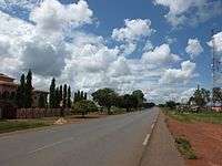
| Capital | Djougou |
| Area[1] | |
| • Total | 11,126 km2 (4,296 sq mi) |
| Population (2013 census) | |
| • Total | 542,605 |
| • Density | 49/km2 (130/sq mi) |
| Time zone | WAT (UTC+1) |
Donga is one of the twelve departments of Benin. The capital of Donga is Djougou. The département of Donga was created in 1999 when it was split off from Atakora Department. Donga is subdivided into five communes, each centered at one of the principal towns, namely, Bassila, Copargo, Djougou Rural, Djougou Urban and Ouaké.
Per 2013 census, the total population of the department was 543,130 with 270,754 males and 272,376 females. The proportion of women was 50.10 per cent. The total rural population was 57.90 percent, while the urban population was 42.10 per cent. The total labour force in the department was 120,021 out of which 24.20 per cent were women. The proportion of households with no level of education was 72.50
Geography
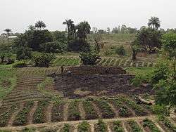
Benin is located in West Africa, bordered by Togo, Niger, Burkina Faso and Nigeria. The northwest regions are usually forested mountains, from which the distributaries of the Niger River, namely, Mekarou and Penjari originate.[2] The northeast plains slope down to the valleys of Niger river. The climate is usually humid and tropical. The nothern regions receive one season of rainfall from May to September, while the southern regions receive two spells from March to July and September to November. The country receives an average annual rainfall of around 1,200 mm (47 in).[3]
Demographics
Per 2013 census, the total population of the department was 543,130 with 270,754 males and 272,376 females. The proportion of women was 50.10 per cent. The total rural population was 57.90 percent, while the urban population was 42.10 per cent. The proportion of women in child bearing age of 15 to 49 years was 23.30 per cent. The total foreign population in the department was 7,760 which formed 1.40 per cent of the total population in the department. The propotion of assets of foreigners aged 10+ years was 31.60 per cent, while for the people aged 15-64 years, it was 30.70 per cent. The proportion of women in foreign population constituted 50.50 per cent. The number of households in the department was 66,433 and the average household size was 8.2. The intercensal growth rate of population was 4.00 per cent.[5]
The average age of women during first marriage in the department was 20.5 and the average age at maternity was 28. The synthetic index of fertility of women was 4.6. The average number of kernels in a house was 1.8 and the average number of persons in a room was 1.8. The total labour force in the department was 120,021 out of which 24.20 per cent were women. The proportion of households with no level of education was 72.50 and the proportion of households with children attending school was 51.40. The crude birth rate was 34.6, general rate of fertility was 148.70 and the gross reproduction rate was 2.30.[4]
Administrative divisions
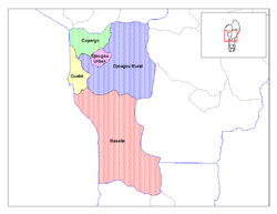
The département of Donga was created in 1999 with an area of 10,691 sq. km., when it was split off from Atakora Department and its capital is Djougou.[6] Donga is subdivided into five communes, each centered at one of the principal towns, namely, Bassila, Copargo, Djougou Rural, Djougou Urban and Ouaké.[7] Benin, formerly known as Dahomey, was a French colony till 1894. It gained independence during 1960 and was admitted to the United Nations. From 1960 to 1972, there was political instability with frequent change of leadership.[8] Benin originally had six administrative divisions, but was further bifurcated to make it 12. Each de-concentrated administrative services, called directions départementales(DD) of the sectoral ministries, take care of two administrative regions. A law passed during 1999 empowered the territorial administration to local governments.[7] Municipalities and communal councils have elected representatives who manage the administration of the regions. The latest elections of the municipal and communal councils were held during June 2015.[9]
References
- ↑ "Benin". Geohive. Retrieved 25 November 2016.
- ↑ McColl, R. W. (2014). Encyclopedia of World Geography, Volume 1. Infobase Publishing. p. 92-93. ISBN 9780816072293.
- ↑ Haggett, Peter, ed. (2002). Encyclopedia of World Geography, Volume 17. Marshall Cavendish. p. 2325. ISBN 9780761473060.
- 1 2 "Socio economic data of Benin, 2013". Institut National de la Statistique et de l’Analyse Economique (INSAE) du Benin. 2013. Retrieved 25 November 2016.
- ↑ "Census of Benin, 2013". Institut National de la Statistique et de l’Analyse Economique (INSAE) du Benin. 2013. Retrieved 25 November 2016.
- ↑ Houngnikpo, Mathurin C.; Decalo, Samuel (2013). Historical Dictionary of Benin. Rowman & Littlefield. pp. 143–4. ISBN 9780810871717.
- 1 2 Republic of Benin, Public Administration and Country profile (PDF) (Report). Department of Economic and Social Affairs (DESA), United Nations. 2004. p. 8. Retrieved 17 November 2016.
- ↑ "Benin country profile". BBC. 5 August 2016. Retrieved 20 November 2016.
- ↑ "Local elections in Benin, 2015". African Elections Database. Retrieved 25 November 2016.