Ouémé Department
| Ouémé | |
|---|---|
| Department | |
|
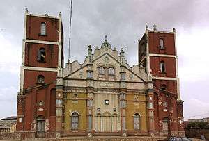
Grande mosque in Porto-novo | |
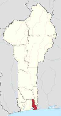 Map highlighting the Ouémé Department | |
| Coordinates: 6°30′N 2°36′E / 6.500°N 2.600°ECoordinates: 6°30′N 2°36′E / 6.500°N 2.600°E | |
| Country |
|
| Capital | Porto-Novo |
| Area[1] | |
| • Total | 1,281 km2 (495 sq mi) |
| Population (2013 census) | |
| • Total | 1,096,850 |
| • Density | 860/km2 (2,200/sq mi) |
| Time zone | WAT (UTC+1) |
Ouémé is one of the twelve departments of Benin. The département of Oueme was split into Plateau Department in 1999 and its area is 1,865 sq. km. Ouémé is subdivided into nine communes, each centered at one of the principal towns, namely, Adjarra, Adjohoun, Aguégués, Akpro-Missérété, Avrankou, Bonou, Dangbo, Porto-Novo and Sèmè-Kpodji.
Per 2013 census, the total population of the department was 1,100,404 with 534,814 males and 565,590 females. The proportion of women was 51.40 per cent. The total rural population was 37.20 percent, while the urban population was 62.80 per cent. The total labour force in the department was 383,716 out of which 49.50 per cent were women. The proportion of households with no level of education was 43.80 and the proportion of households with children attending school was 81.70.
Geography
Mono Department is located in coastal area that have interconnected lakes and lagoons and elongated coastlines with wide marsh. Freshwater and seawater fishing is the major profession in the region. Petroleum was discovered in the 60s in offshore areas, while titanium, low quality iron ore, ilmenite and chromite are the major minerals.[2] The southern regions receive two spells from March to July and September to November while the northern regions of the country receive one season of rainfall from May to September. The country receives an average annual rainfall of around 1,200 mm (47 in), but the region in the department receives relatively lesser rainfall.[3] The department has mostly low-lying sandy coastal plains towards Atlantic Ocean, marshes, lagoons and lakes. The highest elevation in the department around the coastal plains is 20 m (66 ft) compared to the average 200 m (660 ft) above average mean sea level of the country.[4]
Demographics
Per 2013 census, the total population of the department was 1,100,404 with 534,814 males and 565,590 females. The proportion of women was 51.40 per cent. The total rural population was 37.20 percent, while the urban population was 62.80 per cent. The proportion of women in child bearing age of 15 to 49 years was 24.80 per cent. The total foreign population in the department was 17,065 which formed 1.60 per cent of the total population in the department. The propotion of assets of foreigners aged 10+ years was 38.00 per cent, while for the people aged 15-64 years, it was 37.60 per cent. The proportion of women in foreign population constituted 51.40 per cent. The number of households in the department was 232,620 and the average household size was 4.7. The intercensal growth rate of population was 3.70 per cent.[6]
The average age of women during first marriage in the department was 21.7 and the average age at maternity was 28.7. The synthetic index of fertility of women was 4.6. The average number of kernels in a house was 1.2 and the average number of persons in a room was 2.1. The total labour force in the department was 383,716 out of which 49.50 per cent were women. The proportion of households with no level of education was 43.80 and the proportion of households with children attending school was 81.70. The crude birth rate was 36.7, general rate of fertility was 148.20 and the gross reproduction rate was 2.20.[5]
Administrative divisions
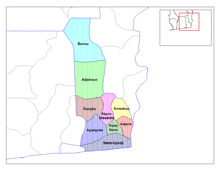
The département of Oueme was split into Plateau Department in 1999 and its area is 1,865 sq. km. Ouémé is subdivided into nine communes, each centered at one of the principal towns, namely, Adjarra, Adjohoun, Aguégués, Akpro-Missérété, Avrankou, Bonou, Dangbo, Porto-Novo and Sèmè-Kpodji.[7][8] Benin, formerly known as Dahomey, was a French colony till 1894. It gained independence during 1960 and was admitted to the United Nations. From 1960 to 1972, there was political instability with frequent change of leadership.[9] Benin originally had six administrative divisions, but was further bifurcated to make it 12. Each de-concentrated administrative services, called directions départementales(DD) of the sectoral ministries, take care of two administrative regions. A law passed during 1999 empowered the territorial administration to local governments.[8] Municipalities and communal councils have elected representatives who manage the administration of the regions. The latest elections of the municipal and communal councils were held during June 2015.[10]
References
- ↑ "Benin". Geohive. Retrieved 25 November 2016.
- ↑ McColl, R. W. (2014). Encyclopedia of World Geography, Volume 1. Infobase Publishing. p. 92-93. ISBN 9780816072293.
- ↑ Haggett, Peter, ed. (2002). Encyclopedia of World Geography, Volume 17. Marshall Cavendish. p. 2325. ISBN 9780761473060.
- ↑ Benin Mineral & Mining Sector Investment and Business Guide. Int'l Business Publications. 2007. pp. 21–22. ISBN 9781433019012.
- 1 2 "Socio economic data of Benin, 2013". Institut National de la Statistique et de l’Analyse Economique (INSAE) du Benin. 2013. Retrieved 25 November 2016.
- ↑ "Census of Benin, 2013". Institut National de la Statistique et de l’Analyse Economique (INSAE) du Benin. 2013. Retrieved 25 November 2016.
- ↑ Houngnikpo, Mathurin C.; Decalo, Samuel (2013). Historical Dictionary of Benin. Rowman & Littlefield. pp. 143–4. ISBN 9780810871717.
- 1 2 Republic of Benin, Public Administration and Country profile (PDF) (Report). Department of Economic and Social Affairs (DESA), United Nations. 2004. p. 8. Retrieved 17 November 2016.
- ↑ "Benin country profile". BBC. 5 August 2016. Retrieved 20 November 2016.
- ↑ "Local elections in Benin, 2015". African Elections Database. Retrieved 25 November 2016.