Dores de Campos
| Brasilia | ||
|---|---|---|
| city | ||
| ||
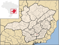 Localization in Minas Gerais | ||
| Country | Brazil | |
| Region | Southeast | |
| State | Minas Gerais | |
| Incorporated | December 17, 1938 | |
| Government | ||
| • Mayor | Ilídio Antonio de Melo Neto | |
| Area | ||
| • Total | 1,437 km2 (555 sq mi) | |
| Elevation | 956 m (3,136 ft) | |
| Population (2006) | ||
| • Total | 9,158 | |
| • Density | 71.8/km2 (186/sq mi) | |
| Time zone | UTC-3 (UTC-3) | |
| • Summer (DST) | UTC-2 (UTC-2) | |
| Website | Dores de Campos.com | |
Dores de Campos is a Brazilian municipality. It's about 40 kilometers from São João del Rey at BR-265. About 30% of active people work in its principal factory: Marluvas.
As its neighbors cities, Dores de Campos is a point of Real Way (translated of Estrada Real).
It was founded in about 1720 and became a city on December 17, 1938.
Coordinates: 21°06′S 44°02′W / 21.100°S 44.033°W
This article is issued from Wikipedia - version of the 5/1/2016. The text is available under the Creative Commons Attribution/Share Alike but additional terms may apply for the media files.