Douglas Harbour
| Douglas Harbour | |
|---|---|
|
Douglas | |
| Location | |
| Country | Isle of Man |
| Location | Douglas |
| Coordinates | 54°8′48.2″N 4°28′2.5″W / 54.146722°N 4.467361°WCoordinates: 54°8′48.2″N 4°28′2.5″W / 54.146722°N 4.467361°W |
| Details | |
| Opened | 1660 |
| Operated by | Isle of Man Government |
| Owned by | Isle of Man |
| Available berths | 16 |
| Piers | 4 |
| Port Pilot | Captain Stephen Carter |
| Port Manager | Captain John Clayton |
| Statistics | |
| Passenger traffic | 635,269 (2008) |
|
Website IoM Gov't Harbours Division | |

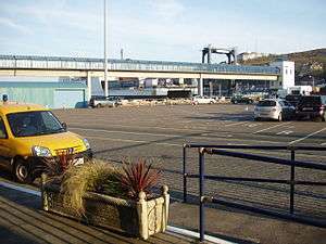
Douglas Harbour (Manx: Purt Varrey Ghoolish) is located near Douglas Head on the southern end of Douglas, the capital town of the Isle of Man. It is the island's main commercial shipping port.
Description
Douglas Harbour is composed of the Outer Harbour and the Inner Harbour separated by the Bascule Bridge and Flapgate. A sea terminal building is located on the northeast end of the harbour co-located with the harbour control.[1]
The Outer Harbour features two jetties, four piers, eleven berths, and an area designated for lifeboats.[1] The piers are:
- Princess Alexandra Pier
- Battery Pier
- King Edward VIII Pier
- Victoria Pier
The two jetties are:
- Fort Anne Jetty
- Oil Jetty
The Inner Harbour allows access and berthing of small vessels.[1]
Traffic
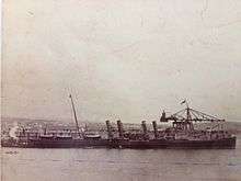
By tonnage, the port's primary traffic is from the Isle of Man Steam Packet Company fleet.
In the vicinity of the Sea Terminal are the following stations/stops which facilitate passenger transport connections:
- Bus Vannin - Lord Street (A1) Depot (Stands A - E) near Parade Street (A11), serves most bus routes[2]
- Bus Vannin - Loch Promenade Stop (Stands F, G) near Regent Street, serves Ramsey and intra-Douglas routes[2]
- Isle of Man Steam Railway - Douglas Railway Station on Bank Hill near Lord (A1) and Athol (A22) Streets.
- Douglas Bay Horse Tramway - Loch Promenade near Victoria Pier
By connecting with the appropriate bus or tramway, sea passengers may also transfer to the Manx Electric Railway to points north.
History
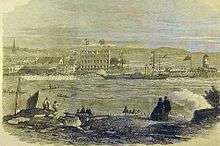
The earliest recorded history indicating the presence of infrastructure facilitating the use of Douglas Harbour dates back to 1660.[3] From the beginning of the 19th Century many things happened to open up the Island to an increasing amount of traffic.[4]
Red Pier
Work on the Red Pier had commenced in 1793 and was completed in 1801. By then the sides of the small Douglas River basin had been shorn up and an attempt had been made to push some sort of protective structure out to sea.[4] It had failed. In 1787 the first pier was reduced to rubble following a series of winter storms and so for many years Douglas Harbour was fully exposed to the easterly gales whilst in the Bay the perilous Conister Rock claimed many vicitms.[4] The Red Pier, built with money from the British Treasury cost £25,000 (equivalent to £1,717,600 in 2015)[5]. It was driven out to the limit of low water, and went more than 50 yards beyond the end of the old wrecked pier which had proceeded it.[4]

Even with the establishment of the Red Pier it was still not until 1871 that passengers were finally able to dispense with the arduous task of having to board rowing boats in order to be ferried to any vessel lying off.[4] The reverse applied when they were disembarking. The scene could be chaotic, and quite often in the winter months passengers would reach the Red Pier from the vessel soaking wet and exhausted.[4]
By 1815 sail was giving way to steam. The first steamer called at the Island on its voyage from the Clyde to Liverpool, and in 1819 James Little opened the first steamship service to the Island, using Douglas as a port of call between Liverpool and Greenock.[4] A year later this service was augmented, with three ships appearing on the station. In announcing the sailings of the Majestic and the City of Glasgow it could be stated that the full journey from the Mersey to the Clyde via Douglas could be made in 25 hours.[4]
Owing to its openness to swell generated by easterly wind, Douglas Bay and the surrounding area had played host to numerous ship wrecks and this culminated in the heroic rescue of the crew of the SS St. George by Sir William Hillary and the crew of the Douglas Lifeboat on the morning of Saturday 20 November 1830.
Douglas Breakwater
Origins
Sir William Hillary had campaigned for the construction of a Breakwater at Douglas so as to afford the harbour greater shelter and to provide a sheltered haven to ships plying in the Irish Sea.[6] Sir William had written a comprehensive paper on the proposal prior to 1835, when more formal proposals were put forward, and design plans drawn up by Sir John Rennie. However, due to bickering no plans were proceeded with and despite campaigning by the Island's press progress in any direction was slow. Much of this was to do with rival proposals for the construction of breakwaters at Peel and Ramsey both of which, as was the case with Douglas, would ultimately rely on approval and funding from the Admiralty. Plans for the Douglas Breakwater were amended by Capt. Vetch but again these were subject to differing opinions and despite the requisite monies being available from 1851 and a further report submitted in 1859, it was not until 1861 that a further set of plans submitted by James Abernethy were approved by the Lords Commissioners of the Admiralty.[7]
Battery Breakwater
The design incorporated landing berths with three platforms at different levels, adapted for loading and unloading at all stages of the considerable tidal range in Douglas with steps for the accommodation of passengers.[7] The rubble stone for the construction was to be procured near the site[7] and the design lent heavily of the Abernethy's previous designs at Blyth, Northumberland, the breakwater at Falmouth, and the piers at Watchet, Bristol Channel and Port Natal, South Africa.[7]
Two breakwaters were initially to be constructed, a southern one and a northern breakwater. The costs submitted were £54,000 (equivalent to £4,544,400 in 2015)[5] for the southern breakwater and £28,500 (equivalent to £2,398,400 in 2015)[5] for the northern breakwater. The estimated time for construction for both structures was two years.[7] This was later amended to construction of the southern breakwater only with the successful tender for the work received from Thomas Jackson of London and a final cost of £47,935 (equivalent to £4,034,000 in 2015)[5] agreed.[8]
Work began in earnest in August 1862, when the brig Thomas Black arrived from London with machinery and a cargo of timber. Work was also cleared to proceed for the breakwaters at Peel and Ramsey with the contract also carried out by Thomas Jackson and with James Abernethy providing the services of a resident engineer and assuming the role of engineer-in-chief himself.[9]
Whilst work slowed during the winter of 1862-63 the schedule was maintained, however an un-seasonal bout of easterly storms in mid May 1863 caused slight damage to the work on the breakwater, but this was quickly put right with little or no disruption to the time scale.
Concerns were expressed by Abernethy as construction continued that the length as initially proposed could effect vessels departing the port during periods of strong southeasterly wind, with particular concern being the chances of a sailing vessel drifting onto the Pollock Rock or St Mary's Isle. Consequently, the drawings were amended and the construction shortened by 250 ft (76.2 m).
During May 1864, serious damage was sustained to the breakwater after supporting timber frames gave way as a consequence of the weight of stone placed on them. This was attributed in a report commissioned by the Harbour Commissioners to non-compliance with certain terms of the specification relative to the stone filling and particularly from neglect to form a homogeneous rubble mound to the level of 15 ft (4.6 m) below low water as the true base of the breakwater, hence the failure of the frames which were placed lower than 15 feet. The quality of the stone being used was also brought into question, with a request for sourcing a better quality in order to furnish the seaward face of the breakwater. In a letter to the Commissioners of the Isle of Man Harbours, Abernethy put forward a recalculated structure of a length of 700 ft (213.4 m) and with a revised cost of completion being £33,705 (£2,891,548 in 2014), (£13,116) less than the original contract sum. In addition a cost was submitted for the improving the roadway to the breakwater. This was submitted at £850 (£72,921 in 2014).
The breakwater sustained significant damage in early February 1865, when a storm described as "unequalled in its fury and unexampled in its effects"[10] pounded the structure washing away many of the timber frames which ended up strewn on Douglas shore.[11] This destruction led to serious questions being raised as to the design of the structure and of Abernethy's reputation. It was not until 7 March, that divers were able to inspect the base of the structure with their findings being that damage had been sustained as far as the 45th frame. The timber uprights had been snapped off however the rubble had not been displaced.[12]
The breakwater was after this not continued with, as it was generally accepted that the calculations and more importantly the method of construction were wrong and that no benefit could be ultimately expected with its continuation. An easterly storm with associated snow on the night of Saturday 5 January 1867, swept away the remaining portion of the breakwater leaving the structure completely demolished.[13]
- Labourer Patrick MacAlinden was killed in the quarry adjoining the Douglas Breakwater on 1 January 1864.
Battery Pier
Following the destruction of Abernethy's breakwater, further plans were commissioned on behalf of the Manx Government by Governor Henry Loch for a more substantial structure of a more modern and purposeful design.[14] Distinguished civil engineer John Coode was appointed in order to survey area of Abernethy's breakwater and to submit his recommendations for the best way to proceed.[14]
Coode made an inspection of the shores around Douglas on 7 & 8 March 1867,[14] and at the same time gave directions for an accurate and detailed survey of the southern portions of Douglas Bay, together with tidal observations and a complete series of soundings in order to prepare drawings and estimates for the new breakwater.[14]
Of particular concern was the effect of easterly wind to which the port was entirely exposed.[14] A second inspection of the shore was made in April, and the report was placed before Tynwald on 10 June 1867.[14] The report detailed certain differences which were found between the findings of Coode in the vicinity of the Pollock Rocks and those of an Admiralty inspection of the same area in 1846. The comparison also encompassed the area around St Mary's Isle.[14]
Coode produced a detailed chart of the bay from Douglas Head to Bank’s Howe with the aforementioned section of St Mary's Isle subjected to a more detailed survey.[14] The survey highlighted a difference in the depth of water in the part of the bay in the vicinity of the ruined breakwater and also to the southeast of Conister Rock/St Mary’s Isle. The depth measured was shown to be some 6 ft (1.8 m) - 9 ft (2.7 m) deeper than those shown on the Admiralty chart of 1846.[14]
Coode submitted a detailed and comprehensive plan for the type of structure required, with emphasis on the structure’s ability to offer adequate shelter to the harbour as well as provision for the regular and safe landing of passengers and mail, not only at all states of the tide but in all states of weather.[14] The structure had to enable steamers to come alongside during periods of off-shore wind so as the port could operate in an efficient manner. In addition to this adequate shelter for the fishing fleet was to be of a high priority. During the mid 19th Century fishing was an integral part of the Island’s economy, the value of the boats and fishing gear which incorporated the Manx Fleet had risen sharply from £52,380 (equivalent to £4,754,100 in 2015)[5] in 1858 to £63,482 in 1865 (equivalent to £5,473,800 in 2015)[5].[14]
In addition to the accommodation of the mail and passenger traffic as well as the fishing fleet, provision had to be made for what was referred to as the Insular Trade and also for trading vessels using that part of the Irish Sea.[14] The idea was put forward that if the necessary funds for the construction were to be met by the Manx Exchequer, then such vessels could be subject to a "refuge toll" if the vessel in question was not trading directly with the Island but rather using the port facilities for shelter only.[14]
The works recommended by Coode were as follows:[14]
- A western arm commencing under the Battery Point, just within Abernethy’s old timber framed breakwater. The arm was to be constructed in a direction of east-by-north for a distance of 250 ft (76.2 m); having a short kant or elbow within its inner end.
- Three hundred feet eastward of this western arm was to be the central breakwater. This would consist of three lengths, the first running east-north-east for 300 ft (91.4 m); the second northeast for 400 ft (121.9 m) and the third north-north-east for 500 ft (152.4 m) making the arm therefore 1,200 ft (365.8 m) in total.
- A northern arm was to commence at a distance of 300 ft (91.4 m) from the northeast end of the central breakwater and would run north-by-west for 400 ft (121.9 m) with a kant of 60 ft (18.3 m) bearing west-by-north.
The western arm was able to utilise the remains of Abernethy’s breakwater. However the rubble mound which was the only remnants of the structure, and was only visible at low water, had to be removed.[14] This task was undertaken by workmen and divers down to a depth of 24 ft (7.3 m) below the low water mark on spring tides.[14]
The northern end of the northern arm was so placed as to protect the anchorage from easterly wind as would be situated seaward of a line drawn to Bank’s Howe Point.[14]
The areas of the different depths of water sheltered within the proposed work were to be:[14]
- Depth - 2 fathoms and upwards at low water: 42 Acres
- Depth - 3 fathoms and upwards at low water: 31 Acres
- Depth - 4 fathoms and upwards at low water: 19 Acres
- Depth - 5 fathoms and upwards at low water: 12 Acres
Arrangements for the lighting of the entrance were to take the form of a small lighthouse tower on the southeast end of the outer end of the landing pier.[14] This contained a powerful condensing apparatus so as to show a coloured light only in the lines of the entrances to the harbour. This enabled an accurate approach to be made at night for the first time.[14]
As had been found during the construction of the earlier breakwater, the stone available from the adjacent quarry was not of a sufficient quality to be used as the main facing stone. However, the quarry was again utilised as the stone available could still be used as foundation rubble stone.[14] This base was laid to a depth of 15 ft (4.6 m) below low water on the sea face and 12 ft (3.7 m) below low water on the harbour face.[14] Above this base work were to be laid massive concrete blocks, made with Portland cement[14] and constructed in a manner which would allow the free escape of water and air when the structure was subjected to heavy seas.[14] This principle had been successfully used on several structures in the Mediterranean[14] and was the only safe and efficient form of construction which could be applied with reasonable economy at places such as Douglas, where there is deep water coupled with a considerable tidal range and an absence of large material in the locality.[14]
It was essential during the course of construction that commerce to and from the Port of Douglas was not affected, as by this time the Island was enjoying the beginnings of a tourism boom[14] and Douglas was the main port of the Isle of Man Steam Packet Company.[14] In order for the construction to co-exist with the workings of the port materials were conveyed by barges towed by steam tugs, the barges having been specially adapted for the purpose.[14]
The proposed time of construction was to be seven years; with the costs detailed as:[14]
Central Breakwater; including the removal of rubble from the former Battery Breakwater £129,280
Permanent installation of concrete blocks £6,480
Lighthouse Tower; including all forms of lighting, foundations and Landing Pier £1,400
Contingencies £17,145
Total £154,305 (equivalent to £12,322,000 in 2015)[5]
As a necessary part of the construction, it was advocated by Coode that the rocks on the shore between the Battery Breakwater and the Fort Anne Jetty as well as on the south face of St Mary’s Isle/Conister Rock should be excavated down to a flat slope so as to form beaching grounds for vessels and fishing boats.[14]
At this time it was generally accepted that a certain degree of danger existed in the port during periods of easterly wind particularly with reference to the entrance between the Red Pier and the Fort Anne Jetty.[14] Coode therefore recommended that upon completion of the western arm of the new breakwater, the eastern end of the Fort Anne Jetty was to be removed.[14] Steamers serving the Island were increasing in size and at this time still had to proceed to anchorage in Douglas Bay following the disembarkation of their passengers.[4]
A committee, presided over by the Island's Lieutenant Governor, was formed to examine the plans submitted by John Coode and to report their recommendations. The committee sat for the first time on 12 June 1867[14] and reported its finding in November.[14] The committee recommended that the plans be adopted but with the proviso that the north arm be dispensed with.[14] The committee further recommended that the sum of £140,000 (equivalent to £11,179,700 in 2015)[5] was to be borrowed from the Public Works Loans Commissioners, upon the security of the insular revenue, under and according to the provisions of the Harbours and Passing Tolls Act, 1861. The term of the repayment of the funds was to be fifty years and the committee also recommended that the works be carried out as soon as the consent of the Board of Trade could be obtained.[14]
However, the proposals were warmly received by members of the local fishing community, as was evident in a letter to the Isle of Man Times of late November 1867.[15]
Despite the committee reporting back in a positive manner, there was opposition to the breakwater scheme. At a Public Meeting called at the Parochial School House, St Johns on Tuesday November 26, 1867, it was moved that further engineering evidence should be sought in order to verify Coode’s report.[16] Whilst not directly, this meeting did ultimately lead to a further examination of the calculations and costs was which undertaken by John Hawkshaw.
Concern had been expressed that the harbour and in particular the landing pier emanating from the Pollock Rocks (later to become the Victoria Pier) would still be very open in periods of strong south-easterly wind. Coode undertook to amend his design in early 1868, and this was then subjected to inspection by Hawkshaw.
There was also some difference of opinion on whether the southern end of the breakwater should begin at a point to the east or the west of Port Skillion. Hawkshaw’s report was completed on February 24, 1868 and laid before Tynwald on March 4. Hawkshaw basically agreed with Coode’s earlier calculations, fully in agreement with Coode’s method of construction. One small difference of opinion was that Hawkshaw recommended a slight amendment of the line of the breakwater at the northeast end. In a letter to Tynwald, Coode cited his work on a similar structure at Alderney as well as emphasising Hawkshaw’s agreement with the costings and calculations and a reaffirmation that the materials recommended would be adequate to withstand the frequent winter storms.
Nevertheless, there was still strong opposition to the construction. Just as had been the case since the first proposal was put forward by Sir William Hillary, various suggestions were made as to the best way to improve the port and no shortage of arguments ensued. This culminated in a petition signed by 182 persons comprising 25 ship owners, 51 master mariners, 10 pilots and 96 other mariners.[17]
A music hall song was even devised, sung to the tune of Sweet Kitty Clover and entitled The Breakwater Dilemma.[18]
One of the most vocal critics of the proposal was the Rev W. B. Christian whose opposition was prompted by his conviction that an enormous outlay was to be made without satisfactory assurance that the best plans for the proposed works had been obtained. Governor Loch worked tirelessly to convince those who still questioned the proposal, meeting the Rev Christian and putting the engineering fact to him in what was described as and affective and conciliatory manner.[19] The questions raised by the Rev Christian were not without foundation. At that time work was being carried out by Coode on the construction of a breakwater at Port Erin, which even by Coode’s own admission the methods of which were showing to be failing in their practicality and application.[20]
The Port Erin Breakwater was to be dogged by allegations of shoddy construction and design. As a consequence it would sustain damage on more than one occasion as a result of gales. Governor Loch persuaded a reluctant Tynwald to grant a sum of £13,000 in order to carry our necessary repairs as a result of damaged sustained in 1868, with the repairs to be completed by 1870. However the breakwater was again damaged in 1882 and was finally destroyed in 1884, after having cost the Manx Government a total of £45,600.
Part of the allegations levelled at the breakwater at Port Erin centred around the rubble base of the structure, which Coode had constructed at 15 feet and which was the same as he intended to carry out at Douglas. The accusations concerning Coode’s reputation became numerous in the local press, even to the extent that allegations were levelled that Coode had mis-led Tynwald.[20]
Notwithstanding these setbacks work was cleared to proceed. Beginning with the re-opening of the quarry situated adjacent to the site and with work on a road beneath the old two gun battery connecting to the South Quay. Work also commenced on arm ‘B’ of the main structure.
Work proceeded without setback through the construction, with an exception being an accident to the foreman which occurred in December, 1872. The foreman, named Johnson, who lived locally at Fort William Rd, Douglas, was carrying out his duties on the edge of the large gantry which had been constructed, when he missed his foothold and fell onto the rocks some 30 feet below. He sustained damage to his ribs, but his injuries were not fatal.[21] Another accident occurred in September 1873, to a labourer named Henry Holden of South Quay Douglas. Holden ran into a winch and was knocked unconscious. He was taken to his home where he was treated by a doctor.[22]
On New Year’s Eve 1874 the Battery Pier sustained damage during the course of the south-easterly gale which continued into New Year’s Day. Following the storm Sir John Coode visited the Island to assess the damage. A preliminary inspection had already been carried out by the Harbour Commissioners who found that the heavy sea had caused damage to the concrete blocks under the low water mark and disturbed them, thus taking away the support of the upper concrete work on the outer sea wall, and causing it to slip off. As a consequence of the subsequent fall, it was found that three of the uprights which supported the framing were carried away, and two of the cross timbers of the staging had been broken.[23]
Upon Coode’s inspection on Tuesday January 5, 1875, it was found that a portion of the wall just above the low water mark measuring about 16 ft 2 in (4.9 m) in length had become detached and had been carried inwards. Also a portion of the adjoining blocks for a depth of two courses had become displaced but were not damaged. However below this and down to the foundation course remained undisturbed. In addition three piles of the tramway staging were broken off.[23]
The costs of the repairs to the damage were calculated to be £600, however no extra cost to repair the damage was incurred as this had been provisioned for in the original cost calculation.[23]
Hazards
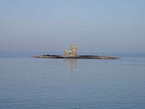
Connister Rock, also known as St Mary's Isle, is a small islet which becomes completely submerged during high tides and removed from sight during stormy, night, or other low visibility conditions. As such, the isle has laid claim to many shipwrecks until the Tower of Refuge was built.[24]
References
- 1 2 3 "New Douglas Harbour Map". Douglas Harbour. Isle of Man Government Harbours Division. 2009. Retrieved 24 August 2009.
- 1 2 Department of Tourism & Leisure (2008). "Douglas Depot". Isle of Man Government. Archived from the original on 12 April 2009. Retrieved 26 August 2009.
- ↑ "Harbours history". Isle of Man Government. Retrieved 7 September 2013.
- 1 2 3 4 5 6 7 8 9 Island Lifeline. Connery Chappell, (1980)
- 1 2 3 4 5 6 7 8 UK CPI inflation numbers based on data available from Gregory Clark (2016), "The Annual RPI and Average Earnings for Britain, 1209 to Present (New Series)" MeasuringWorth.
- ↑ Manx Sun. Friday October 2nd, 1835
- 1 2 3 4 5 Manx Sun. Saturday January 18th, 1862.
- ↑ Manx Sun. Saturday May 24th, 1862.
- ↑ Manx Sun. Saturday January 21st, 1863.
- ↑ Manx Sun. Saturday February 4th, 1865
- ↑ Manx Sun. Saturday February 4th, 1865
- ↑ Mona's Herald. Wednesday March 8th, 1865.
- ↑ Mona's Herald. Wednesday January 9th, 1867.
- 1 2 3 4 5 6 7 8 9 10 11 12 13 14 15 16 17 18 19 20 21 22 23 24 25 26 27 28 29 30 31 32 33 34 35 36 37 Mona's Herald. Wednesday June 19th, 1867.
- ↑ Isle of Man Times Saturday November 30, 1867
- ↑ Mona’s Herald Wednesday November 27th, 1867
- ↑ Mona’s Herald 25-03-1868
- ↑ Mona’s Herald 08.04.1868
- ↑ Mona’s Herald 08-04-1868
- 1 2 Manx Sun 27-06-1868
- ↑ Mona’s Herald 11-12-1872
- ↑ Mona’s Herald 20-09-1873
- 1 2 3 Mona’s Herald. 07-01-1875
- ↑ "St Mary's Isle". Manx Telecom. Retrieved 7 September 2013.
- Bibliography
- Chappell, Connery (1980). Island Lifeline T.Stephenson & Sons Ltd ISBN 0-901314-20-X
External links
- Isle of Man Government Harbours Division
- Isle of Man Bus and Rail Timetables
- Realtime Ship Movements near Douglas Harbour (ShipAIS)