Drakovouni
| Drakovouni Δρακοβούνι,Γλόγοβα | |
|---|---|
 Drakovouni | |
| Coordinates: 37°46.5′N 22°07′E / 37.7750°N 22.117°ECoordinates: 37°46.5′N 22°07′E / 37.7750°N 22.117°E | |
| Country | Greece |
| Administrative region | Peloponnese |
| Regional unit | Arcadia |
| Municipality | Gortynia |
| Municipal unit | Kleitor |
| Elevation | 781 m (2,562 ft) |
| Community[1] | |
| • Population | 66 (2011) |
| Time zone | EET (UTC+2) |
| • Summer (DST) | EEST (UTC+3) |
| Postal code | 220 02 |
| Area code(s) | 27950 |
| Vehicle registration | TP |
| Website | http://drakovouni.blogspot.gr/ |
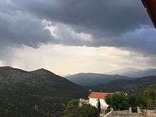
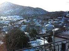
Drakovouni (Greek: Δρακοβούνι, before 1927: Γλόγοβα - Glogova[2]), Arcadia, Greece is a remote village in the municipality of Gortynia, Arcadia, Peloponnese, Greece. It is situated at 780 m elevation, on the slope of a mountain also called Drakovouni, 1,077 m elevation. It is 4 km west of Prasino, 9 km south of Filia and 37 km northwest of Tripoli. The few year-round residents are involved in agriculture. The village is known for the victorious battle of the guerrillas against the Nazis on April 20, 1944. Drakovouni has an elementary school, four churches, and three monasteries.
Historical population
| Year | Population |
|---|---|
| 1981 | 250 |
| 1991 | 120 |
| 2001 | 178 |
| 2011 | 66 |
See also
References
- ↑ "Απογραφή Πληθυσμού - Κατοικιών 2011. ΜΟΝΙΜΟΣ Πληθυσμός" (in Greek). Hellenic Statistical Authority.
- ↑ Name changes of settlements in Greece
External links
- http://arcadia.ceid.upatras.gr/arkadia/places/drakovouni.htm
- http://www.inarcadia.gr/dd/drakovouni/img/drakov3-500.htm
- GTP - Drakovouni
This article is issued from Wikipedia - version of the 10/10/2016. The text is available under the Creative Commons Attribution/Share Alike but additional terms may apply for the media files.