Drayton, Leicestershire
| Drayton | |
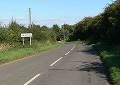 Approaching Drayton |
|
 Drayton |
|
| Population | 254 (2011) |
|---|---|
| OS grid reference | SP8303992202 |
| District | Harborough |
| Shire county | Leicestershire |
| Region | East Midlands |
| Country | England |
| Sovereign state | United Kingdom |
| Post town | Market Harborough |
| Postcode district | LE |
| Police | Leicestershire |
| Fire | Leicestershire |
| Ambulance | East Midlands |
| EU Parliament | East Midlands |
|
|
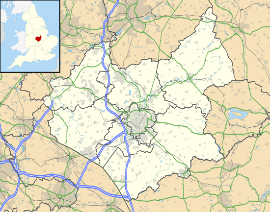
Coordinates: 52°31′16″N 0°46′37″W / 52.521°N 0.777°W
Drayton is a small village and civil parish in the Harborough district of south-east Leicestershire, bordering Northamptonshire and Rutland. It is situated 6.7 miles (11 km) northeast of Market Harborough and 5 miles (7.5 km) southwest of Uppingham on the north side of the Welland valley. Nearby villages are Bringhurst, Great Easton and Nevill Holt. The church of St. James in Drayton is one of the smallest churches in England.
History[1]
Drayton grew up around an oval green of which the present green is the north-western end. West of the green, Drayton House is a tall red-brick structure, built in 1851–2 for Bryan Ward, a tenant of the Rockingham estate. South of the road to Great Easton the present Manor House Farm, or College Farm, was built c. 1870–80, probably for a relative of Lord Sondes, whose arms it carries. Its cart shed, a dilapidated ironstone structure retaining several stone-mullioned windows, was once a large house carrying the inscription 'H.N. 1651 T.W.' on a stone now built into the wall of the field behind. This was probably the chief messuage of the manor belonging to Henry Nevill and occupied by his tenants, the Watson family. The older houses in the village are of ironstone and include a thatched cottage south of Drayton House in which part of a cruck blade has been re-used as a principal rafter. A mutilated cruck truss is visible in a derelict stone cottage north of the road to Easton. The former Plough Inn is a stone building, partly thatched, of which the older portions probably date from the 17th century. A stone cottage on the road to Easton has a tablet of 1791, a date at which ironstone was evidently still in general use. The village contains several 19th century brick cottages, including a row dated 1870. There are two pairs of Council houses on the Great Easton road built after the First World War and three pairs on the road to Nevill Holt, built in 1950. The village hall, given by Mr. Webb of Drayton House, is a wooden structure which was opened in 1925.
Conservation Area
Drayton is one of 62 conservation areas[2] within the Harborough District of Leicestershire. The Conservation Area embraces the area of the village around the village green together with the older part of the village along the road to Great Easton. Blocks of later development on the Great Easton Road and the Nevill Holt Road are excluded as the style of buildings does not contribute to the traditional feel of the village. The Conservation Area includes the traditional buildings around the green and along Hall Lane and the main street towards Great Easton. Visually the most dominant part of the Conservation Area is around the open space of the village green which gives cohesion to the settlement. From the Medbourne Road the entrance to this open area is sudden and is firmly defined by a former farmhouse and its agricultural buildings. These extend partially along one side of the triangular Green. Open roads run on each of the three sides of the green in whose centre is the tiny single cell Church of St. James.[3]
Census data
In the 1870s, Drayton was described as being:
- "A township in Bringhurst parish, Leicester; near the river Welland, 2 miles West of Rockingham. Pop., 126. Houses, 29.The village of Drayton had a population of 137 according to the 1881 census. 10 years later, the population had decreased by 32 to just 105. By 1901, this had shrunk even further, to just 93 residents. The 1911 census saw a small increase in the village's population by just 8 residents to a total of 101. 1921's census shows another decrease in population (this time only by 4) to 97 residents. After this, it once again began to rise quite significantly to 121 residents in 1931. 20 years on, following World War II, the 1951 census found a population of 99 residents, presumably due to loss of lives during the war. The 1961 census saw another gradual increase in population to 112.[4] By the time of the 2011 census,50 years later, the population of Drayton had increased quite drastically when considering the size of the village and past population data, by 117 people to 254 residents.[5]
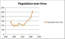 Population of Drayton, 1881 to 2011
Census data shows the changing number of households in the village of Drayton. The first census in 1881 showed that there were just 30 houses in the village which is not surprising considering the villages small population of just 137 in this year. By 1891, the total number of households in the village was had increased by 7 to 137 and in 1901 had decreased again to 35. Following World War 1, the 1921 census showed that the total number of houses in Drayton had decreased to 29. In 1931 it had increased once more to 37 houses. 20 years later, following World War 2, the total house number was 35 and finally, the 1961 census showed a total house number of 37.[6] 50 years later, the 2011 census of Drayton showing a total of 96 households in Drayton.[7]
Church of St James
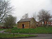
The church of St. James stands on the green in Drayton and was listed as being Grade II on 7 December 1966.[8] It is a single room built of stone and roofed with slate, constructed on the site of the former chapel which fell out of religious use in the 18th century and had been converted into a bake-house by 1794. In 1878, George Lewis Watson of Rockingham Castle bought the building and proceeded to remodel it throughout 1878-79 into a Mission Church.[9] The door is in the centre of the south side; the east end has one and the west end two lancet windows. A bell on a bracket projects from the east end. A large semi-circular arch internally suggests that it was of 12th-century origin. It is said to be Leicestershire's smallest consecrated church.[10]
References
- ↑ "Bringhurst | British History Online". www.british-history.ac.uk. Retrieved 2015-12-26.
- ↑ England, Historic. "Living in a Conservation Area | Historic England". historicengland.org.uk. Retrieved 2016-03-24.
- ↑ Council, Harborough District. "Drayton Conservation Area". www.harborough.gov.uk. Retrieved 2016-03-24.
- ↑ "Changing Populations of Drayton through time". Retrieved 20 March 2013.
- ↑ "Drayton (Parish): Key Figures for 2011 Census: Key Statistics". Neighbourhood Statistics. Office for National Statistics. Retrieved 10 March 2013.
- ↑ "Vision of Britain: Changing House Number of Drayton, Leicestershire". Retrieved 9 April 2013.
- ↑ "2011 census : Accommodation Type - Households 2011". Retrieved 9 April 2013.
- ↑ "British Listed Buildings: Church of St James, Drayton". Retrieved 20 March 2013.
- ↑ "St James' Drayton - A History". Retrieved 20 March 2013.
- ↑ "Panoramio: Drayton Village Church. St James, said to be the smallest church in Leicestershire".
External links
![]() Media related to Drayton, Leicestershire at Wikimedia Commons
Media related to Drayton, Leicestershire at Wikimedia Commons