Nationaal beek- en esdorpenlandschap Drentsche Aa
| Drentsche Aa National Park | |
|---|---|
| Nationaal beek- en esdorpenlandschap Drentsche Aa | |
|
IUCN category V (protected landscape/seascape) | |
|
The Drentsche Aa | |
 Map of the National Park | |
| Location | Drenthe, Netherlands |
| Coordinates | 53°3′N 6°39′E / 53.050°N 6.650°ECoordinates: 53°3′N 6°39′E / 53.050°N 6.650°E |
| Area | 100 km2 (39 sq mi)[1] |
| Established | 2002[1] |
| Governing body | Het Overlegorgaan Nationaal beek- en esdorpenlandschap Drentsche Aa |
| http://www.drentscheaa.nl/ | |
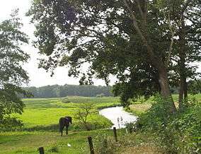
The Nationaal beek- en esdorpenlandschap Drentsche Aa is a national park located in the Dutch province of Drenthe on the west side of the Hondsrug. It consists of the cultural landscape surrounding the valley of the small river the Drentsche Aa. The landscape is currently nearly the same as it was in the mid 19th century, as the several agricultural landscape reforms of the 20th century were not implemented in this area. Because of this, many hedges, heathlands and traditionally managed fields ('essen' in Dutch) were spared from transformation. The national park is part of the (three times) larger national landscape Drentsche Aa.
References
- 1 2 (English) NP Drentse Aa English.pdf
External links
-
 Media related to Drentsche Aa at Wikimedia Commons
This article is issued from Wikipedia - version of the 8/4/2016. The text is available under the Creative Commons Attribution/Share Alike but additional terms may apply for the media files.