Dubingiai
| Dubingiai | ||
|---|---|---|
|
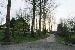
The church in Dubingiai | ||
| ||
 Dubingiai Location of Dubingiai | ||
| Coordinates: 55°03′40″N 25°27′00″E / 55.06111°N 25.45000°E | ||
| Country |
| |
| Ethnographic region | Aukštaitija | |
| County |
| |
| Municipality | Molėtai district municipality | |
| Eldership | Dubingiai eldership | |
| Capital of | Dubingiai eldership | |
| First mentioned | 1334 | |
| Population (2001) | ||
| • Total | 239 | |
| Time zone | EET (UTC+2) | |
| • Summer (DST) | EEST (UTC+3) | |
Dubingiai is a town in Molėtai district in Lithuania. It is situated near Lake Asveja, the longest lake in the country. The town has 260 inhabitants as of 2003.
History
.jpg)
The settlement was first mentioned in 1334, when Teutonic knights razed terra Dubingam during one of their raids. Other raids took place in 1373 and 1375. During the reign of the Grand Duke of Lithuania Vytautas the Great the town became an important place in that part of Lithuania. In 1415 Vytautas ordered the building of a new masonry castle.
Later it was governed by the Radziwiłłs who built Dubingiai Castle from rock and town became one of the centres of the Reformation in Lithuania. Many famous members of Radziwiłł family were burned and are buried in the churchyard of Dubingiai castle. In the 17th century a weave and paper manufactures were established in the town. In the 17th century - 18th century the town was slowly re-converted to Catholicism.
A massacre of over 20 Lithuanian inhabitants by a local Armia Krajowa unit occurred on 23 June 1944, during World War II.[1][2] The crime was a retaliation by the Polish commander for an earlier massacre of Polish villagers in Glitiškės by collaborationist Lithuanian police.[1][2]
Gallery
 The remains of Evangelicals reformators church
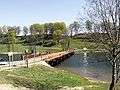 The bridge of Dubingiai
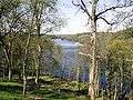 Asveja near Dubingiai
References
- 1 2 Piotrowski, Tadeusz (1997). Poland's Holocaust. McFarland & Company. ISBN 0-7864-0371-3. p.168, p.169
- 1 2 (Polish) Gazeta Wyborcza, 2001-02-14, Litewska prokuratura przesłuchuje weteranów AK (Lithuanian prosecutor questioning AK veterans), last accessed on 7 June 2006
External links
| Wikimedia Commons has media related to Dubingiai. |
- (Lithuanian) Website of Dubingiai
Coordinates: 55°04′N 25°27′E / 55.067°N 25.450°E
| Municipalities |  | |
|---|---|---|
| Cities | ||
| Towns | ||
| Villages | ||